March 2 |
The offensive intensifies on three fronts
Russian troops are preparing a three-pronged siege of Kiev, according to the Institute for the Study of War (IWS).
The Russians have been near the capital to the
north
for days , in the Gostomel airport area, about 30 kilometers away.
There they would have the bulk of their contingent, according to UK intelligence.
The invaders could also try to reach the city from the
west
.
In the last hours there have been bombings in Borodyanka, 60 kilometers northwest of the capital.
There are also images of tanks opening fire between civilian buildings.
Russian shelling in a residential area of
Zhytomyr
, west of Kiev.
Reuters.
Debris after an attack in
Borodyanka
, outside Kiev.
@RALee85.
A tank fires at
Borodyanka.
@COUPSURE (Cen4infoRes)
Bombings in
Irpin
.
@Den_2042.
The third front of the offensive on Kiev would be to come from the
east
, if they advance from already won territories near Chernihiv, they could meet forces advancing from Sumy.
Russian troops have been located in Bobrovytsya, some 80 kilometers northeast of the capital.
"The objective is to surround the city and force mass evacuations of Ukrainian civilians," suggests analyst Franz-Stefan Gady, from the International Institute for Strategic Studies (IISS).
The rest of the offensive on Ukraine
In the northeast, fighting continues in Kharkov, according to a statement from the Ukrainian Army collected by the BBC.
The second Ukrainian city is one of the main fronts of the invasion.
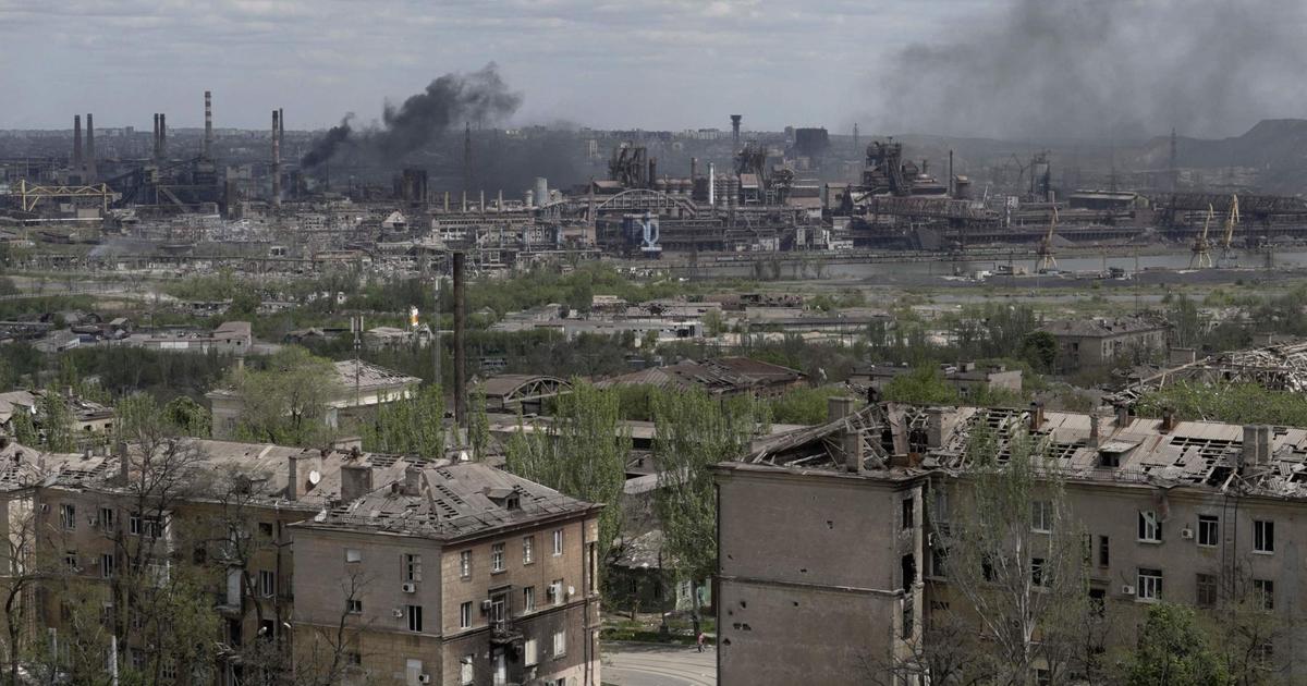
In the south of the country, Russian troops control Berdyansk, forcefully enter Kherson and claim to have surrounded the large town of Mariupol.
With their latest advances, they unite two vast areas that were under their control, Donbas and Crimea.
Russian-occupied areas (as of March 1)
fighting
bombings
BELARUS
RUSSIA
North
northeast
Sumy
Kyiv
Kharkiv
UKRAINE
donbas
Central
nuclear
Zaporizhia
East
MOLD.
Kherson
Odessa
Mariupol
Berdyansk
ROMANIA
South
crimea
250km
annexed by
Russia in 2014
Black Sea
Sources: Occupied Territories
(Institute for the Study of War).
Russian-occupied areas (as of March 1)
fighting
bombings
RUSSIA
BELARUS
North
Kursk
Chernyhyv
northeast
Voronezh
Belgorod
Sumy
POLAND
Kyiv
Kharkiv
Ivano-Frankivsk
UKRAINE
East
donbas
Lugansk
Zaporizhia
Central
nuclear
Donetsk
MOLD.
Kherson
Mariupol
ROMANIA
Berdyansk
South
crimea
annexed by
Russia in 2014
Black Sea
250km
Sources: Occupied Territories (Institute for the Study of War).
Russian-occupied areas (as of March 1)
fighting
bombings
BELARUS
RUSSIA
Kursk
North
Voronezh
northeast
Chernihiv
Belgorod
exclusion zone
from Chernobyl
Sumy
Lutsk
POLAND
Kyiv
Kharkiv
Ivano-Frankivsk
millevoro
UKRAINE
donbas
East
Lugansk
Zaporizhia
Central
nuclear
Donetsk
MOLD.
Rostov-on-Don
Kherson
Odessa
Mariupol
Berdyansk
ROMANIA
South
crimea
annexed by
Russia in 2014
Black Sea
250km
Sources: Occupied Territories (ISW), Rochan Consulting and agencies.
The Russian army has intensified bombing raids on Kiev, Kharkov, Chernihiv and Mariupol since Tuesday, according to British intelligence.
Dozens of missile impacts against civilian buildings are counted.
Past days
March 1 |
Offensive on Kiev
After a warning from the Russian Army to the population of
Kiev
, Putin's troops have bombed the capital's television tower.
It is feared that it is the beginning of a new offensive.
After two days of relative pause, early on Tuesday three signs heralded more hostilities: a huge convoy of military vehicles headed for Kiev, troops were piling up in eastern Ukraine and the bombardment of the city of
Kharkov
intensified.
Russian-occupied areas (as of February 28)
fighting
bombings
BELARUS
RUSSIA
North
northeast
Kyiv
Járkov
UCRANIA
Donbás
Central
nuclear
Zaporiyia
Este
MOLD.
Jersón
Odesa
Mariupol
RUMANIA
Sur
Crimea
250 km
Anexionada por
Rusia en 2014
Mar Negro
Fuentes: Territorios ocupados
(Instituto para el Estudio de la Guerra).
Áreas ocupadas por Rusia (a 28 de febrero)
Combates
Bombardeos
BIELORRUSIA
RUSIA
Norte
Noreste
Kiev
Járkov
UCRANIA
Donbás
Central
nuclear
Zaporiyia
Este
MOLD.
Jersón
Odesa
Mariupol
RUMANIA
Sur
Crimea
250 km
Anexionada por
Rusia en 2014
Mar Negro
Fuentes: Territorios ocupados
(Instituto para el Estudio de la Guerra).
Áreas ocupadas por Rusia (a 28 de febrero)
Combates
Bombardeos
RUSIA
BIELORRUSIA
Norte
Kursk
Noreste
Chernyhyv
Voronezh
Belgorod
POLONIA
Kiev
Járkov
Ivano-Frankivsk
UCRANIA
Este
Donbás
Lugansk
Zaporiyia
Central
nuclear
Donetsk
MOLD.
Jersón
Mariupol
RUMANIA
Sur
Crimea
Anexionada por
Rusia en 2014
Mar Negro
250 km
Fuentes: Territorios ocupados (Instituto para el Estudio de la Guerra).
Áreas ocupadas por Rusia (a 28 de febrero)
Combates
Bombardeos
BIELORRUSIA
RUSIA
Kursk
Norte
Voronezh
Noreste
Chernihiv
Belgorod
Zona de exclusión
de Chernóbil
Lutsk
POLONIA
Kiev
Járkov
Ivano-Frankivsk
Millevoro
UCRANIA
Donbás
Este
Lugansk
Zaporiyia
Central
nuclear
Donetsk
MOLD.
Rostov del Don
Jersón
Odesa
Mariupol
RUMANIA
Sur
Crimea
Anexionada por
Rusia en 2014
Mar Negro
250 km
Fuentes: Territorios ocupados (ISW), Rochan Consulting y agencias.
The bulk of the Russian contingent stalking the capital is about 30 kilometers from the northwest, UK intelligence reported in the morning.
It is the area of the
Gostomel airport,
a facility that the Russians bombed days ago.
There the Ukrainian forces stopped their advance.
Satellite images have captured a very long caravan of military vehicles in the direction of the capital.
This convoy can try to enter Kiev from the north or try to go around the city from further south.
Prybirsk
Part of the route of the convoy heading towards Kiev, photographed by satellite on February 28.
Ivankiv
4km
To Kyiv
(50 km in
straight line)
Satellite image: Maxar Technologies.
Prybirsk
Part of the route of the convoy heading towards Kiev, photographed by satellite on February 28.
4km
Ivankiv
To Kyiv
(50 km in
straight line)
Satellite image: Maxar Technologies.
Part of the route of the convoy heading towards Kiev, photographed by satellite on February 28.
Bohdany
Prybirsk
Bolotnia
Sukashi
Ivankiv
Shpyli
Zaprudka
To Kyiv
(50 km in
straight line)
Fenevichy
Katyuzhanka
Sosnivka
2km
Satellite image: Maxar Technologies.
Bad
Makarivka
Bohdany
Makarivka
Rusaky
Prybirsk
Part of the route of the convoy heading towards Kiev, photographed by satellite on February 28.
Sukashi
Bolotnia
Ivankiv
Shpyli
Zaprudka
To Kyiv
(50 km in
straight line)
Fenevichy
Katyuzhanka
Sosnivka
2km
Satellite image: Maxar Technologies.
Ground and air attack
Varios testigos documentan el avance de tanques y otros medios de combate rusos alrededor de Borodyanka, a las afueras de Kiev. Las fuerzas rusas también han incrementado el uso de artillería en los alrededores de Járkov y Chernihiv, según la inteligencia de Reino Unido. El uso de fuego pesado en áreas densamente pobladas incrementa mucho el riesgo de víctimas civiles.
Tanques cerca de Kiev (verificado por Cen4infoRes). YWNReporter (Cen4infoRes).
Bombardeo en Járkov. Telegram, vía @polinaivanovva.
Información por: Kiko Llaneras, Mariano Zafra, Luis Sevillano, José A. Álvarez, Montse Hidalgo, Daniele Grasso, Borja Andrino y Javier Galán.
28 de febrero | Explosiones en Járkov
Rusia mantiene su ataque sobre Ucrania en cuatro frentes. Pero durante el fin de semana apenas logró avances. Según el Instituto para el Estudio de la Guerra (IWS), “las fuerzas rusas en gran medida llevaron a cabo una pausa operativa” del sábado al domingo. En la madrugada de este lunes, tanto en Kiev como en Járkov, volvieron a escucharse potentes explosiones.
Áreas ocupadas por Rusia (a 27 de febrero)
Combates
Bombardeos
BIELORRUSIA
RUSIA
Norte
Noreste
Zhytomyr
Kiev
Járkov
UCRANIA
Donbás
Central
nuclear
Zaporiyia
Este
MOLD.
Jersón
Odesa
Mariupol
RUMANIA
Sur
Crimea
250 km
Anexionada por
Rusia en 2014
Mar Negro
Fuentes: Territorios ocupados
(Instituto para el Estudio de la Guerra).
Áreas ocupadas por Rusia (a 27 de febrero)
Combates
Bombardeos
RUSIA
BIELORRUSIA
Norte
Kursk
Noreste
Chernyhyv
Voronezh
Belgorod
POLONIA
Kiev
Zhytomyr
Járkov
Ivano-Frankivsk
UCRANIA
Este
Donbás
Lugansk
Zaporiyia
Central
nuclear
Donetsk
MOLD.
Jersón
Mariupol
RUMANIA
Sur
Crimea
Anexionada por
Rusia en 2014
Mar Negro
250 km
Fuentes: Territorios ocupados (Instituto para el Estudio de la Guerra).
Áreas ocupadas por Rusia (a 27 de febrero)
Combates
Bombardeos
BIELORRUSIA
RUSIA
Kursk
Norte
Voronezh
Noreste
Chernihiv
Belgorod
Zona de exclusión
de Chernóbil
Lutsk
POLONIA
Kiev
Zhytomyr
Járkov
Ivano-Frankivsk
Millevoro
UCRANIA
Donbás
Este
Lugansk
Zaporiyia
Central
nuclear
Donetsk
MOLD.
Rostov del Don
Jersón
Odesa
Mariupol
RUMANIA
Sur
Crimea
Anexionada por
Rusia en 2014
Mar Negro
250 km
Fuentes: Territorios ocupados (ISW), Rochan Consulting y agencias.
En el noreste del país, continuaron los bombardeos sobre Járkov, la segunda ciudad más poblada. Al menos 11 personas murieron este lunes bajo el fuego ruso sobre distritos residenciales, según autoridades ucranias.
Los rusos bombardean Járkov desde hace días, aunque hasta ahora sus tropas han sido repelidas por las fuerzas ucranias. Este lunes las bombas cayeron cerca de un centro comercial al noreste, después de que el domingo los rusos trataran de entrar en la ciudad por esa misma zona, según The New York Times.
Las tropas terrestres rusas han llegado a ser vistas dentro de la ciudad. Este lunes varios videos localizados en la calle Shevchenko, una de las arterias principales, mostraban los restos de camiones militares rusos abandonados tras la batalla.
Las imágenes satélite de ayer domingo ya mostraban los efectos de nuevos bombardeos sobre Járkov, con decenas de cráteres alrededor de la calle Soborna. Es una de las carreteras de entrada hacia la ciudad, a 14 kilómetros del centro, y está rodeada de naves industriales y áreas residenciales.
Nuevos
cráteres
Járkov
Área
residencial
Área
residencial
Nuevos
cráteres
Norte
Centro
comercial
Fuente: BlackSky.
Nuevos
cráteres
Járkov
Área
residencial
Área
residencial
Nuevos
cráteres
Norte
Centro
comercial
Fuente: BlackSky.
Nuevos cráteres
Área
residencial
Járkov
Área
residencial
Nuevos
cráteres
Nuevos
cráteres
Centro comercial
Nuevos
cráteres
Norte
Fuente: BlackSky.
Nuevos cráteres
Área
residencial
Járkov
Área
residencial
Nuevos
cráteres
Nuevos
cráteres
Centro comercial
Nuevos
cráteres
Norte
Fuente: BlackSky.
En el sur, las tropas se acercan a Zaporiyia, donde se encuentra la mayor central nuclear de Europa, y mantienen rodeada Mariupol desde el oeste. Según autoridades ucranias, citadas por Reuters, hubo combates toda la noche cerca de Mariupol. Los rusos también se mueven alrededor de Jersón, pero no han logrado apoderarse de la ciudad.
Ambas fuerzas se disputan en estos momentos el control de la central nuclear de Zaporiyia, según recoge Reuters. Mientras que las autoridades rusas afirman haber tomado el sitio, la empresa ucrania que gestiona las instalaciones lo desmiente y dice que sigue suministrando electricidad a todo el país. La exrepública soviética cuenta con otras tres centrales activas.
Zaporiyia
Central nuclear
Río Dniéper
Reactores
Reactores nucleares
Chernóbil
(inactiva)
Rivne
Khmelnitsky
Ucrania Sur
Zaporiyia
Zaporiyia
Central nuclear
Río Dniéper
Reactores
Reactores nucleares
Chernóbil
(inactiva)
Rivne
Khmelnitsky
Ucrania Sur
Zaporiyia
Reactores nucleares
Zaporiyia
Chernóbil
(inactiva)
Rivne
Khmelnitsky
Central nuclear
Ucrania Sur
Zaporiyia
Río Dniéper
Río Dniéper
Central nuclear
de Zaporiyia
Reactores
La central de Zaporiyia, que comenzó a operar en 1984, tiene seis reactores y genera 5.700 MWe, una quinta parte de la energía que se produce en el país y el 47% de la que se obtiene del conjunto de las centrales nucleares ucranias.
Reactores nucleares
Zaporiyia
Chernóbil
(inactiva)
Rivne
Khmelnitsky
Central nuclear
Ucrania Sur
Zaporiyia
Río Dniéper
Reactores
Central nuclear
de Zaporiyia
Río Dniéper
La central de Zaporiyia, que comenzó a operar en 1984, tiene seis reactores y genera 5.700 MWe, una quinta parte de la energía que se produce en el país y el 47% de la que se obtiene del conjunto de las centrales nucleares ucranias.
En el norte, los convoyes militares rusos están avanzando hacia el frente de Kiev desde la ciudad de Ivankiv, a unos 100 kilómetros por carretera de la capital.
Rusaky
Prybirsk
Ivankiv
Hacia Kiev
100 km
4 km
Imagen satelital: Maxar Technologies.
Rusaky
Prybirsk
Ivankiv
Hacia Kiev
(100 km)
4 km
Imagen satelital: Maxar Technologies.
Khocheva
Rusaky
Makarivka
Prybirsk
Bolotnia
Ivankiv
Hacia Kiev
(100 km)
2 km
Imagen satelital: Maxar Technologies.
Khocheva
Mala
Makarivka
Makarivka
Rusaky
Prybirsk
Bolotnia
Ivankiv
Zaprudka
Hacia
Kiev
100 km
2 km
Imagen satelital: Maxar Technologies.
Información por: Kiko Llaneras, Mariano Zafra, Luis Sevillano, José A. Álvarez, Montse Hidalgo, Daniele Grasso y Borja Andrino.
27 de febrero | La lucha continúa en Ucrania y Kiev resiste
Russian troops barely gained ground this Saturday in their offensive on Ukraine.
The fight continues in
Kiev
, where soldiers and militiamen resist between detonations and bursts of shots.
The Russians have continued to advance towards the capital from the
north
, but now they are also advancing from the
northeast
.
There is also the battle for Kharkov, where Russian vehicles have been seen.
In the
south
, the town of Berdyansk, near Mariupol and on the outskirts of Kherson, has fallen to Russian troops.
Russian-occupied areas (as of February 26)
fighting
Bombing (from 26)
BELARUS
RUSSIA
North
northeast
Belgorod
sumi
Kyiv
Vasylkov
Kharkiv
UKRAINE
donbas
East
MOLD.
Melitopol
Odessa
Kherson
Mariupol
Berdyansk
ROMANIA
South
crimea
250km
annexed by
Russia in 2014
Black Sea
Sources: Occupied Territories
(Institute for the Study of War).
Russian-occupied areas (as of February 26)
fighting
Bombings (from February 26)
RUSSIA
BELARUS
North
Kursk
northeast
Voronezh
Belgorod
sumi
POLAND
Kyiv
Vasylkov
Kharkiv
Poltava
Ivano-Frankivsk
UKRAINE
East
donbas
Lugansk
Donetsk
MOLD.
Melitopol
Kherson
Odessa
Mariupol
ROMANIA
Berdyansk
South
crimea
annexed by
Russia in 2014
Black Sea
250km
Sources: Occupied Territories (Institute for the Study of War).
Russian-occupied areas (as of February 26)
fighting
Bombardment (from the 25th)
BELARUS
RUSSIA
Kursk
Voronezh
North
northeast
Belgorod
exclusion zone
from Chernobyl
sumi
Lutsk
POLAND
Kyiv
Vasylkov
Kharkiv
Poltava
Ivano-Frankivsk
millevoro
UKRAINE
Dnipro
East
donbas
Lugansk
Donetsk
MOLD.
Rostov-on-Don
Mykolayiv
Melitopol
Mariupol
Odessa
Kherson
Berdyansk
ROMANIA
South
crimea
annexed by
Russia in 2014
Black Sea
250km
Sources: Occupied Territories (ISW), Rochan Consulting and agencies.
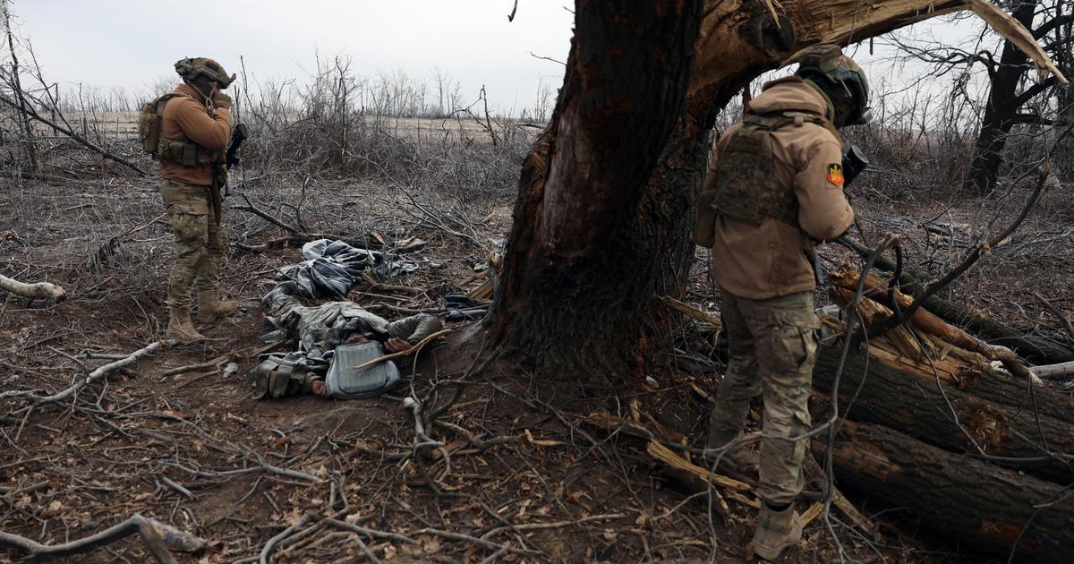
Battle at Bucha-Irpin (near Kiev)
Una zona de fuego este domingo ha sido la calle que une las localidades de Bucha e Irpín, a cuatro kilómetros de Kiev. La batalla se produjo cuando fuerzas rusas trataban de avanzar hacia Kiev, según fuentes ucranias que recoge Reuters. Las imágenes tras la contienda muestran cadáveres sobre el asfalto, viviendas derruidas y tanques destruidos.
Calle Soborna tras el combate (Irpín)
Calle Vokzalna, en Bucha, tras el ataque
Tanques rusos destrozan una escultura en Bucha
Soldados caídos y edificios destruidos en Irpín
Un satélite de la NASA, que habitualmente se usa para detectar fuegos forestales, señala puntos de calor en la zona.
El primer tramo es la vía Vokzalna, en Bucha, que continúa con el nombre de Soborna al entrar en Irpín. El puente que une ambos tramos podría haber sido destruido, según medios locales.
There are images of Russian vehicles circulating and opening fire at various points on the street, verified by the Bellingcat group and the Center for Information Resilience.
But the Russian advance appears to have been unsuccessful, at least initially.
Later videos show the Russian vehicles destroyed and several dead soldiers.
The images of the fronts
Russian forces have killed at least 198 people, including three children, and injured 1,115, according to information from the Ukrainian National Guard.
Southwest of the capital, the bombing of oil installations has caused a large fire in the town of Vasylkov.
Burning oil installations after a shelling in
Vasylkov
, in the Kiev region.
Maxim Levin / Reuters.
Ukrainian servicemen take up positions at the Vasylkov
military air base
, Kiev.
BlackSky.
Ukrainian military truck on fire on a highway in
Kharkiv.
milinfolive (Telegram), via Cen4infoRes.
Russian military equipment destroyed after combat in
Mykolaiv
.
Shaun Walker (Twitter), via Cen4infoRes.
In Kiev, the authorities decreed a curfew that lasted from Saturday afternoon to Sunday morning.
Only soldiers, emergency workers and armed volunteers were allowed to take to the streets.
Deserted streets after the curfew decreed in Kiev for Sunday, February 27. Umit Bektas (Reuters)
An exodus of 368,000 people
Thousands of Ukrainians try to leave their country fleeing from the Russian attack.
This Sunday there were already 368,000 refugees, most of them women and children, according to the United Nations Refugee Agency (UNHCR).
His spokesman, Shabia Mantoo, says that figure could rise to four million.
Ukrainians between the ages of 18 and 60 have been banned from leaving the country.
The road flow is continuous.
According to Google, there is heavy traffic on all major thoroughfares connecting Ukraine with its neighbors to the east and south.
Half of the refugees would have arrived in Poland, but there are also arrivals in Slovakia, Hungary, Romania and Moldova.
February 26 |
The battle for Kiev rages on
Las tropas rusas continúan atacando Ucrania por cuatro frentes. Ayer avanzaron por tres de ellos. Por el norte ganaron terreno hasta alcanzar Kiev; por el noreste, alrededor de las ciudades de Járkov y Sumy; y por el sur, desde Crimea y en varias direcciones. En la capital han continuado los combates y las explosiones en el tercer día del ataque rusos. Testigos citados por Reuters informan de ataques en el centro de la capital, cerca de la sede del Gobierno.
A las 8.12 del sábado, un misil ha impactado un edificio residencial. El Gobierno ucranio asegura que es un ataque ruso. En las imágenes se ven apartamentos destruidos en varias plantas. El edificio se encuentra al oeste.
Un edificio del centro de Kiev impactado por un misil en la madrugada del sábado, 26 de febrero |EFE
Un edificio del centro de Kiev impactado por un misil en la madrugada del sábado, 26 de febrero |EFE
Un edificio del centro de Kiev impactado por un misil en la madrugada del sábado, 26 de febrero |EFE
A building in central Kiev hit by a missile
in the early hours of Saturday, February 26 | EFE
Northwest
Kiev
, where the main attacks are being reported, has been closed to traffic since Friday.
At 10 am on Saturday (CET) all access to the northwest of the city is blocked.
|
Googlemaps traffic monitoring tool
Information by: Kiko Llaneras, Mariano Zafra, Luis Sevillano, José A. Álvarez and Montse Hidalgo.
February 25 |
Russian troops besiege Kiev
El Ministerio del Interior de Ucrania reportó fuertes explosiones en la capital. Las fuerzas rusas atacaron con especial intensidad el viernes Kiev. El Ejército ruso cargaba contra infraestructuras civiles. El Gobierno de Kiev informó de decenas de muertos y heridos en ataques por todo el país. El balance cifraba en al menos 137 las víctimas mortales.
Desde el jueves se han sucedido las imágenes del asalto a la capital. En el interior, las tropas ucranias intentan repeler el avance del Ejército ruso en las vías de acceso la ciudad.
Tropas ucranias defienden el puente de la Habana en Kiev. Luis De Vega.
Soldados ucranios se repliegan desde el puente. Luis De Vega.
Aeronave derribada en la zona residencial de Pozniaky. AP / Oleksandr Ratushniak.
Russian helicopter attack on
Gostomel airport
.
Ukrainian Police.
Information by: Kiko Llaneras, Mariano Zafra, Luis Sevillano, José A. Álvarez and Montse Hidalgo.
February 24 |
Russia attacks Ukraine
Russian troops attack Ukraine on three fronts: to the north, along the border with Belarus;
to the east, across the border with Russia;
and to the south, from Crimea, the peninsula that Russia illegally invaded and annexed in 2014. The Ukrainian government denounces "a large-scale attack from multiple directions."
Russian troops occupied ground on all fronts, as data from the Institute for the Study of War (IWS) showed.
combat zones
fronts
occupied territories
for Russia
bombings
RUSSIA
North
BELARUS
East
exclusion zone
from Chernobyl
POLAND
Kyiv
Kharkiv
Under control
from Ukraine
UKRAINE
donbas
MOLD.
Odessa
Under control
of separatists
pro-Russian
ROMANIA
South
crimea
250km
Black Sea
Sources: Bombings and occupied territories
(Institute for the Study of War)
combat zones
fronts
occupied territories
for Russia
bombings
RUSSIA
North
BELARUS
East
exclusion zone
from Chernobyl
POLAND
Kyiv
Kharkiv
Under control
from Ukraine
UKRAINE
donbas
MOLD.
Odessa
Under control
of separatists
pro-Russian
ROMANIA
South
crimea
Black Sea
250km
Sources: Bombings and occupied territories
(Institute for the Study of War)
fronts
Russian occupied territories
combat zones
bombings
RUSSIA
BELARUS
North
Kursk
Voronezh
Belgorod
exclusion zone
from Chernobyl
Sumy
Lutsk
POLAND
East
Kyiv
Kharkiv
Under control
from Ukraine
Ivano-Frankivsk
UKRAINE
Dnipro
donbas
Lugansk
Donetsk
MOLD.
Mariupol
Odessa
Kherson
ROMANIA
Under control
of separatists
pro-Russian
South
crimea
Black Sea
250km
Sources: Bombings and occupied territories (Institute for the Study of War)
fronts
Russian occupied territories
combat zones
bombings
BELARUS
RUSSIA
Kursk
Voronezh
North
Belgorod
exclusion zone
from Chernobyl
Sumy
Lutsk
POLAND
East
Kyiv
Kharkiv
Under control
from Ukraine
Ivano-Frankivsk
millevoro
UKRAINE
Dnipro
donbas
Lugansk
Donetsk
MOLD.
Rostov-on-Don
Mariupol
Odessa
Under control
of separatists
pro-Russian
Kherson
ROMANIA
South
crimea
Black Sea
250km
Sources: Bombings and occupied territories (Institute for the Study of War)
The escalation of tension in Eastern Europe ended up spilling over on Thursday.
Russian President Vladimir Putin announced "a special military operation" at dawn, and the attack on Ukraine began minutes later.
The objective, according to the Russian president, is to demilitarize the country, although the attack against the former Soviet republic increasingly resembles a full-scale invasion.
More information
Russia and Ukraine: last hour of the war, live
A primera hora del jueves se registraron explosiones en, al menos, 10 regiones en el este y el sur del país. El Ministerio de Defensa ruso afirma estar usando “armas de alta precisión” para inutilizar la infraestructura militar.
Bombardeos en Kiev en la madrugada del jueves
Edificio alcanzado por un proyectil en Chuguiv
La policía acordona una zona bombardeada en Kiev
Búsqueda de supervivientes en edificios destrozados
The first explosions were heard minutes after six in the morning on Thursday.
Attacks have been recorded in a dozen Ukrainian cities.
In Sloviansk and Kramatorsk, to the east;
in Kharkov, to the northeast, just 30 kilometers from the Russian border;
and even in Kiev, the capital.
There have also been explosions in the separatist regions of Donetsk and Lugansk, whose independence the Russian government recognized last Monday.
Pictures of the first attack
Smoke and flames following an attack on a military facility in
Kiev
, Ukraine.
AP/Efrem Lukatsky.
Damaged array of radars and other equipment at a military facility near
Mariupol
, Ukraine.
AP/Sergei Grits.
Ukrainian soldiers in an armored vehicle in the
Kharkov
region .
REUTERS/Antonio Bronic.
Military vehicles cross the
border between Crimea and Ukraine
in a picture taken by security cameras.
DPA.
The concentration of troops
Satellite images showed movements of Russian tanks and soldiers in regions around Ukraine, where according to US intelligence, Putin's army had deployed up to 190,000 troops.
The image below shows the Bolshoy Bokov airfield, in Mazyr (Belarus), at two times — on February 4 and 22 — and the arrival of 100 vehicles and dozens of barracks.
Information by: Luis Sevillano, Mariano Zafra, Kiko Llaneras, Jose A. Álvarez, Montse Hidalgo, and Daniel Castresana (Video).
Satellite image: AFP / Maxar Technologies.
February 22 |
Russia sends troops to Ukraine's Donbas region
Putin has ordered the sending of troops to Donbas after signing the recognition of the independence of Lugansk and Dontesk
Belgorod
Kharkiv
RUSSIA
LUGANSK
UKRAINE
Under control
from Ukraine
DONBAS
Lugansk
DONETSK
area under control
of the separatists
pro-Russian
Donetsk
Rostov-on-Don
UKRAINE
Sea of Azov
100km
Putin has ordered the sending of troops to Donbas after signing the recognition of the independence of Lugansk and Dontesk
Belgorod
Kharkiv
RUSSIA
LUGANSK
UKRAINE
Under control
from Ukraine
DONBAS
Lugansk
area under control
of the separatists
pro-Russian
DONETSK
Donetsk
Sea of Azov
UKRAINE
100km
UKRAINE
soloti
Valuyki
Kharkiv
RUSSIA
LUGANSK
Under control
from Ukraine
Millerovo
UKRAINE
DONBAS
Lugansk
area under control
of the separatists
pro-Russian
DONETSK
Donetsk
Putin has ordered the sending of troops to Donbas after signing the recognition of the independence of Lugansk and Dontesk
Mariupol
Berdyansk
Sea of Azov
100km
Belgorod
soloti
UKRAINE
Valuyki
Kharkiv
RUSSIA
LUGANSK
Under control
from Ukraine
Millerovo
UKRAINE
DONBAS
Lugansk
area under control
of the separatists
pro-Russian
DONETSK
Putin has ordered the sending of troops to Donbas after signing the recognition of the independence of Lugansk and Dontesk
Donetsk
Rostov-on-Don
Mariupol
100km
Sea of Azov
Putin consummated last Monday night the recognition of the self-proclaimed popular republics of Donetsk and Lugansk, as the Duma had requested days before, and sent troops to the zone under separatist control of the Donbas region.
More information
Putin envía tropas a las regiones separatistas del este de Ucrania tras reconocer su independencia
La guerra en el este de Ucrania dura ya ocho años. En marzo de 2014, Rusia se anexionó tras un referéndum que la comunidad internacional consideró ilegal la península de Crimea, y ofreció apoyo militar y económico a los separatistas del Donbás. Un mes después, estos proclamaron su independencia de Ucrania, lo que precipitó el inicio del conflicto, que desde entonces ha dejado más de 14.000 muertos.
La contienda ha dividido el Donbás en dos áreas separadas por la línea del frente: la zona controlada por los separatistas respaldados por Rusia, en la frontera con ese país, y la que sigue bajo dominio de las Fuerzas Armadas de Ucrania, en el oeste. Los separatistas reclaman todo el territorio de Donetsk y Lugansk, pero solo controlan un tercio —unos 10.400 kilómetros cuadrados según la Organización de Seguridad y Cooperación en Europa (OSCE)—.
13 de febrero. Despliegue de tropas y grupos de batalla en la localidad rusa de Soloti, cerca de la región del Donbás.
20 de febrero. Convoy del batallón de fusileros en movimiento al noreste de la guarnición de Soloti.
February 20th.
New detachment located east of
Valuyki
, in Russia.
February 20th.
Small detachment deployed along a line of trees northwest of
Belgorod
.
Maxar Technologies.
Information by: Trinidad Deiros, Mariano Zafra, Luis Sevillano, Montse Hidalgo.
Satellite photos: Maxar Technologies.
February 20 |
The buildup of Russian troops in Donbas
Russian troops
Without number
of troops
known
5,000
1,000
Updated: January 27
BELARUS
RUSSIA
Kyiv
UKRAINE
donbas
Transnistria
MOLDOVA
ROMANIA
crimea
Black Sea
250km
On February 21, Putin recognizes the independence of the provinces of Lugansk and Donetsk and orders the sending of troops to the region.
Crimea was annexed by Russia in 2014. Donbas is a Ukrainian region where Russian-backed separatists control a third of the territory.
Russian troops
Without number
of troops
known
5,000
1,000
Updated: January 27
LITHUANIA
RUSSIA
BELARUS
Kyiv
UKRAINE
donbas
Transnistria
MOLDOVA
ROMANIA
crimea
250km
Black Sea
On February 21, Putin recognizes the independence of the provinces of Lugansk and Donetsk and orders the sending of troops to the region.
Crimea was annexed by Russia in 2014. Donbas is a Ukrainian region where Russian-backed separatists control a third of the territory.
Russian troops
Without number
of troops
known
5,000
1,000
Updated: January 27
Moscow
RUSSIA
LITHUANIA
Kaliningrad
On February 21, Putin recognizes the independence of the provinces of Lugansk and Donetsk and orders the sending of troops to the region.
BELARUS
POLAND
Kyiv
UKRAINE
donbas
Transnistria
MOLDOVA
crimea
Krasnodar
ROMANIA
250km
Black Sea
Crimea was annexed by Russia in 2014. Donbas is a Ukrainian region where Russian-backed separatists control a third of the territory.
5,000
Russian troops
Without number
of troops
known
Actualizado:
20 de febrero
1.000
Moscú
LITUANIA
Kaliningrado
RUSIA
Minsk
POLONIA
BIELORRUSIA
Cracovia
Voronezh
Chernóbil
Kiev
Rusia mantiene presencia militar en la región separatista moldava de Transnistria desde los años noventa
UCRANIA
El 21 de febrero Putin reconoce la independencia de las provincias de Lugansk y Donetsk y ordena el envío de tropas a la región.
Lugansk
ESLOV.
Donbás
Donetsk
HUNGRÍA
Transnistria
MOLDAVIA
Mar de Azov
Crimea
Krasnodar
RUMANIA
Mar Negro
250 km
Crimea fue anexionada a Rusia en 2014. Donbás es una región ucrania en la que separatistas apoyados por Rusia controlan un tercio del territorio.
Rusia comenzó en noviembre a acumular tropas y armamento junto a su frontera con Ucrania. La consultora Rochan Consulting, que ha estado monitorizando el despliegue, calculaba el 27 de enero que más de 100.000 soldados rusos estaban ya desplegados cerca de la frontera. Los últimos movimientos de Rusia y el inicio de lo que Rochan califica como “una nueva fase”, en la que las unidades están pasando de congregarse en puntos de reunión a actuar en zonas de maniobras más dispersas, complica ahora el seguimiento y el recuento de los destacamentos sobre el terreno. De acuerdo con fuentes occidentales citadas por la británica BBC, dos tercios de estas tropas rusas se encuentran ahora a menos de 50 kilómetros de la linde con el territorio ucranio.
Además de los soldados desplegados en la frontera con Ucrania, Moscú mantiene a 30.000 soldados, armamento pesado y aviones y helicópteros de combate en Bielorrusia.
El embajador de Estados Unidos ante la Organización para la Seguridad y la Cooperación en Europa (OSCE), Michael Carpenter, calculó el viernes que entre las tropas rusas instaladas junto a la frontera ucrania, las que Moscú mantiene en Crimea y las desplegadas en Bielorrusia, el Kremlin puede tener sobre el terreno entre 169.000 y 190.000 militares en los límites con Ucrania. A ese importante despliegue, hay que sumar los alrededor de 2.000 militares que, según datos del think tank polaco Warsaw Institute, Moscú mantiene en Transnistria, una región cuya población de lengua y cultura rusa declaró su independencia de Moldavia en 1990.
Information by: Trinidad Deiros, Mariano Zafra, Luis Sevillano.
January 29 |
invasion options
BELARUS
RUSSIA
Belgorod
Kyiv
Total
dnieper river
UKRAINE
donbas
Vinnytsia
Dnipro
Odessa
MOLD.
ROMANIA
East
South
250km
crimea
Black Sea
BELARUS
RUSSIA
Belgorod
Kyiv
Total
dnieper river
UKRAINE
donbas
Vinnytsia
Dnipro
Odessa
MOLD.
ROMANIA
East
South
crimea
250km
Black Sea
BELARUS
Troebortnoe
Mazur
RUSSIA
POLAND
Chernobyl
Belgorod
Kyiv
Total
dnieper river
Lviv
UKRAINE
Vinnytsia
donbas
SLOV.
Dnipro
Lugansk
Donetsk
HUNGARY
MOLD.
melitopl
Odessa
East
ROMANIA
South
250km
Black Sea
crimea
BELARUS
Troebortnoe
Mazur
RUSSIA
POLAND
korosten
Chernobyl
Belgorod
East Option
Kyiv
Lviv
dnieper river
full option
UKRAINE
Vinnytsia
Uzhorod
donbas
Kremenchuk
SLOV.
Dnipro
Lugansk
Donetsk
HUNGARY
MOLDOVA
South Option
melitopl
Odessa
Kherson
Rostov-on-Don
ROMANIA
crimea
250km
Black Sea
Analysts believe that the most plausible scenarios of an alleged Russian invasion of Ukraine are three:
1. South option.
Russian troops would try to conquer the strip of Ukrainian territory bordering the Black Sea.
That strip would go from the Donbas region to Transnistria, in Moldova, passing through the Crimean peninsula, illegally annexed by Russia in 2014. This possibility would ensure the water supply to Crimea, which Kiev cut off eight years ago, and would leave Ukraine landlocked.
2. Opción Este. Los soldados rusos podrían penetrar en las zonas separatistas del Donbás, sin avanzar más en Ucrania, o bien intentar conquistar todo el territorio ucranio al este del río Dniéper, que divide el país en dos mitades. Este avance militar incluiría la toma de Kiev con la posible colaboración de las tropas rusas estacionadas en Bielorrusia, cuya frontera se encuentra a 80 kilómetros de la capital.
3. Opción total. Una invasión de toda Ucrania es el escenario que los expertos consideran más improbable por la dificultad de controlar un territorio de más de 600.000 kilómetros cuadrados y a una población de 44 millones de personas, según el Banco Mundial. La oposición de la ciudadanía es un factor que puede ser más determinante incluso que la resistencia puramente militar de las Fuerzas Armadas ucranias, en manifiesta inferioridad frente al Ejército ruso. Además de la diferencia abismal en términos de armamento, Ucrania cuenta solo con 209.000 militares en activo frente a los 900.000 del Ejército ruso, de acuerdo con datos del Instituto Internacional de Estudios para la Paz de Estocolmo (SIPRI en sus siglas en inglés).
Información por: Andrea Rizzi, Mariano Zafra
01:57
Videoanálisis: el papel de Donbás en el conflicto de Ucrania
A Ukrainian soldier keeps watch in a position near the village of Katerynivka, not far from the city of Luhansk, controlled by pro-Russian militants. Photo: ZURAB KURTSIKIDZE (EFE) |
Video: EPV
Sources: Center for Strategic and International Studies (CSIS), Maxar Technologies, Rochan Consulting.
Follow all the international information on
and
, or in
our weekly newsletter
.