
March continues to be rainy after the very dry months of January and February.
If in the first 20 days of the month 44% more precipitation than the average was collected on these dates, or even triple in some area, this week has begun, will continue and will end with abundant and widespread rainfall, especially in points of the Mediterranean.
In the center and north of the Valencian Community, where this Tuesday will be the seventh consecutive day of widespread rains, more than 300 liters per square meter can accumulate until Friday, half of what it usually rains in a whole year, Rubén details. del Campo, spokesperson for the State Meteorological Agency (Aemet).
There, where the Fallas of last week were already the rainiest for 84 years, where in the last 24 hours up to 279 have been collected,
mascletàs
and the Nit Màgica have had to be cancelled―, there have been overflowing rivers, roadblocks and a string of incidents, although no personal damage.
Nine communities have warnings activated, all of them at a yellow level - the lowest on a scale of three - due to rain, wind or rough seas.
These are Andalusia, the Balearic Islands, Castilla y León, Catalonia, Muria, Navarra, the Basque Country, La Rioja, and the Valencian Community.
#Pluges
📹 On video, the rescue of the two occupants of a vehicle in Quart de Poblet.
💧Seguim recomanant molta caució davant the crescuda de barrancs or rambles.
pic.twitter.com/MVyM6IPW3m
– Bombers Consortium VLC (@BombersValencia) March 21, 2022
The cause of the opening of the hose on the Peninsula, explains the meteorologist, is the arrival of successive Atlantic storms, while the flow of humid winds from the Mediterranean persists.
In addition, from the rains the wind will blow strongly and the Mediterranean will be choppy for much of the week.
In the extreme north of the peninsula, the atmosphere will be calmer and temperatures will generally be higher than normal, especially in the northern third, where it will rain less, while in the Mediterranean regions they will be somewhat cooler.
Monday was already very rainy, with 107 liters in Castellón;
70 in Piornal (Cáceres);
66 in La Pinilla (Segovia), and 63 in Navacerrada (Madrid).
This Tuesday, the skies will continue to be very cloudy, with widespread rainfall again.
Although less intense and frequent than on Monday, they will be persistent and locally strong in the north of the Valencian Community, east of Teruel and south of Tarragona, where more than 70/80 liters per square meter can accumulate in 12 hours.
They can also be abundant in points of the Central System and be accompanied by a storm in Extremadura and western Andalusia.
The snow level will drop to 1,100/1,300 meters in the Pyrenees and 1,300/1,600 meters in the rest.
The winds will be intense in much of the country, especially in the Balearic Islands and in the eastern Cantabrian.
In the Mediterranean area there will be maritime storms,
I open a thread with the maps planned for today and the next three days.
#Probability Precipitation forecast from today, Monday, March 21 to Thursday, March 24.
More variables and longer period of time at: https://t.co/F9epZNXUyR.
(1/7) pic.twitter.com/ImHmVz58Na
– CésarRgzBallesteros (@crballesteros) March 21, 2022
On Wednesday another storm will arrive in the southwest of the Peninsula and, at the same time, the flow of humid winds will persist in the Mediterranean, which will give rise to a "very rainy" day, with widespread precipitation on the Peninsula and the Balearic Islands.
The largest accumulations are expected again in the Valencian Community, where rainfall will be strong and persistent, especially in the north, as well as in the east of Castilla-La Mancha, Murcia and eastern Andalusia.
They can also be persistent in the Central System and locally strong with storms in western Andalusia.
Again, the rains will be unlikely and weak if they occur in Galicia, Cantabrian Sea and the Pyrenees.
The snow level will go from 1,300 to 1,700 meters and the wind will blow strong in the Mediterranean area and even very strong in areas of the southeast.
This day,
On Thursday and Friday, Del Campo expects intense rainfall to continue in the Mediterranean and Balearic regions, with strong and persistent local rains in the center and north of the Valencian Community and in the surroundings of Murcia, eastern Andalusia and Malaga.
In the western third they will be weaker and it will rain little in the northern third, where they will continue with unchanged temperatures and a snow level of 1,300 to 1,500 meters.
And beware, that dust in suspension may arrive again that will give rise to haze in Melilla, in the southeast of the peninsula and in the Balearic Islands - but nothing to do with the extraordinary episode of last week - with intense winds in the Mediterranean and in areas of Mountain.
During the weekend the instability will tend to subside, although the rains will still continue in Catalonia, the Valencian Community and the Balearic Islands, and new Atlantic fronts with rains may begin to arrive from the southwest.
A general rise in temperatures is also expected.
In the Canary Islands, the start of the week will be stable until winds arrive from the north on Wednesday, causing a drop in temperature and rains in the north and interior of the islands with greater relief.
Over the weekend the winds will shift to the southwest and will blow strong in high areas and the rains will mainly affect the western islands.
Evolution of the surface situation for the next 72 hours, https://t.co/XZgPFkyP2Q pic.twitter.com/whEqC1JnF0
– AEMET (@AEMET_Esp) March 22, 2022
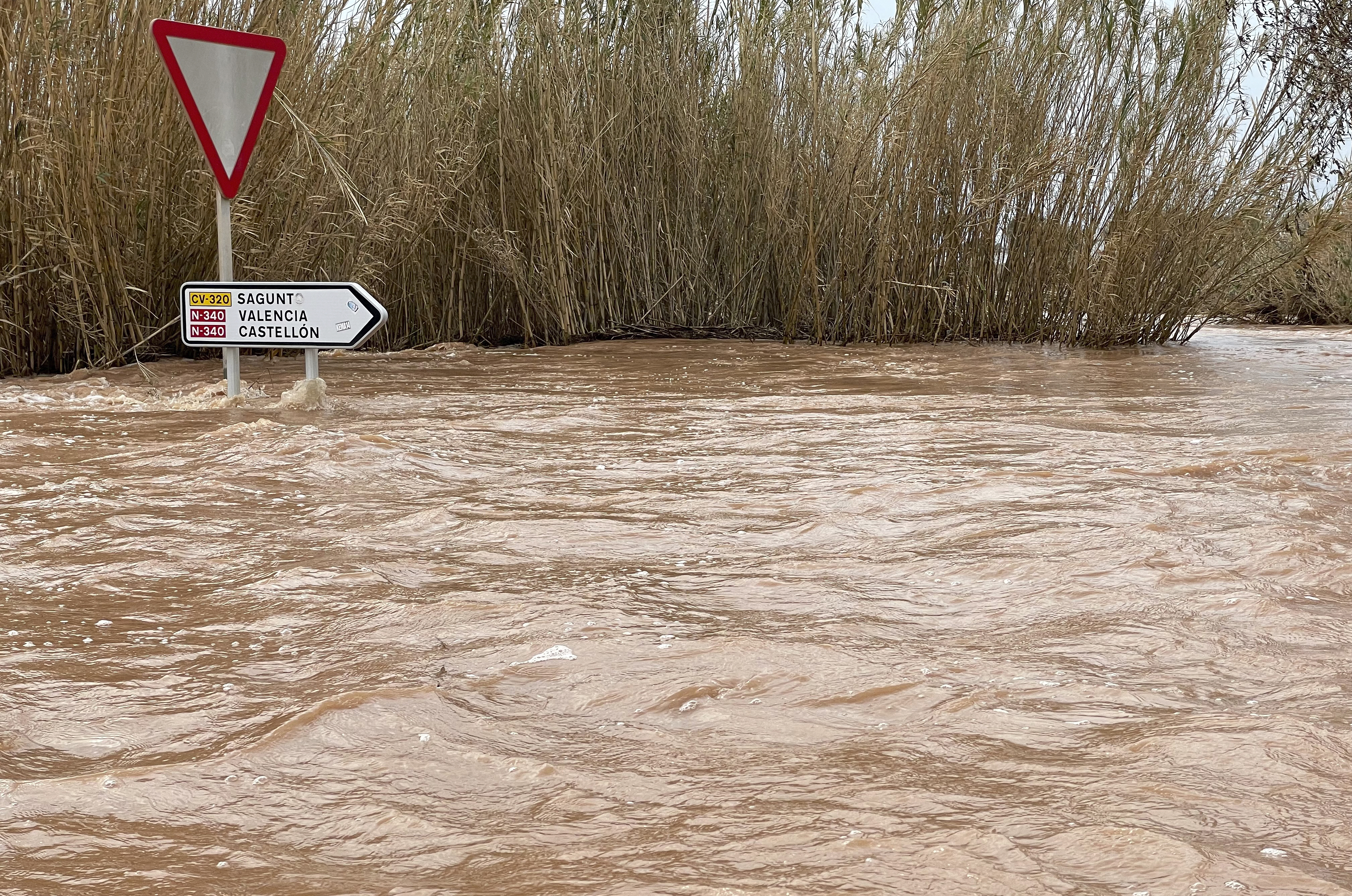
Incidents in the Valencian Community
EFE
The intense rainfall in the Valencian Community has caused the Magro and Belcaire rivers to overflow, as well as a ravine and the cut of the N-III road in Utiel (Valencia).
In addition, in Borriana (Castellón), there is a danger of the Anna River overflowing and, although the trend is decreasing, the emergency situation 0 (the lowest) has been declared, according to Emergencies of the Generalitat Valenciana.
In Alboraya (Valencia), the overflow of the Barranco del Carraixet has forced the evacuation of 15 people at the mouth and there are several roads cut.
In Algemesí and Guadassar, in the province of Valencia, there has been an overflow of the Magro river and an increase in the flow as it passes through the Huerto de Mulet, where 400 cubic meters per second have been reached, although it is already declining.
In Moncofa (Castellón), where the Belcaire River has overflowed its banks, although the level has dropped considerably and the trend is decreasing, there are problems with the entry of seawater into the area of the mouth.
As a result of the intense rains, the N-III road has been cut, at kilometer 265, in both directions in the municipality of Utiel (Valencia).