Historic heat wave will impact several parts of the US 0:46
(CNN) --
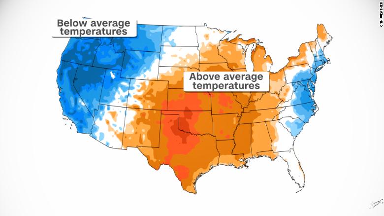
A notable heat wave with typical August temperatures will hit much of Texas, the Plains and the Midwest this weekend through early next week.
Between Friday and Tuesday, 120 temperature records are expected to be equaled or exceeded in at least 13 states, with heat indices, which combine temperature and humidity to forecast how hot it feels, close to 43.3 ° C in some cases.
Central and West Texas will see some of the hottest temperatures, including the city of San Angelo.
Texas is used to scorching temperatures, but the heat in early May usually means temperatures between 25 and 32°C, not to exceed 37.7°C.
"It's pretty rare to have such an extreme heat wave in early May. Usually this is the kind of heat we see in July or August," said Stephen Harrison, a meteorologist with the National Weather Service in San Angelo.
High temperatures in San Angelo are forecast to soar between 39.4°C and 40.5°C, almost 11 degrees above seasonal averages and rivaling records that have stood since the 1920s.
If you add humidity, it will feel closer to 43.3°C in the afternoon.
Most of the state will heat up with temperatures between 32.2C and 37.7C and it will feel even hotter this weekend.
advertising
High temperatures will be above average across much of the central United States.
NWS Meteorologist Matthew Brady cautions that given extreme heat indices, limiting outdoor exposure is paramount this Mother's Day weekend.
“Heat exhaustion and heat stroke are possible during such a heat wave, so staying hydrated, staying in the shade, and reducing outdoor exposure is a must if you plan to be outdoors this weekend.” said Brady, located in Austin, Texas.
"When heat waves come this early in the year, people are often not acclimatized, so there's always a risk of heat-related illness, especially during such a long event," Harrison told CNN.
Historically, heat waves are the deadliest weather catastrophe in the US, killing nearly 150 people a year, more than hurricanes and tornadoes combined.
The widespread nature of the heat in Texas has already prompted authorities to prepare for increased demand on the power grid.
The Electric Reliability Council of Texas (ERCOT) announced Wednesday that it is asking power plants to postpone outages and lift ongoing outages "in order to serve Texans this weekend." ".
According to the statement, ERCOT will deploy all available tools to manage the network reliably and anticipates that there will be enough generation to meet electricity demand.
The council has come under scrutiny after record cold temperatures in February 2021 saw the state record the highest electricity demand and more than 200 people lost their lives during the electricity crisis, with hypothermia being the leading cause of death. common.
Texas is not the only state that is going to suffocate in the coming days.
Summer-worthy temperatures are also expected in parts of the Southwest, Plains, South and Midwest.
More than 50 temperature records are expected Saturday and Sunday from west in Albuquerque, New Mexico, to east in New Orleans.
By Monday and Tuesday, record heat will spread farther north and east, affecting Saint Louis, Memphis, Nashville and Indianapolis.
Another 70 record highs could be reached or broken early next week as temperatures hover between 25°C and 32°C.
Record high temperatures are possible next week as we warm into the upper 80s and low 90s across the region.
Here's a look at the high temperature forecast compared to the record highs.
#ilwx #mowx #stlwx pic.twitter.com/ndhZ3HENUv
— NWS St. Louis (@NWSStLouis) May 5, 2022
The heat will worsen the drought
Excessive heat will add insult to injury for those fighting an early fire season and will continue to intensify already dire drought conditions.
Extreme to exceptional drought, the two worst categories, in both Texas and New Mexico has widened greatly in recent weeks and is likely to continue with the next heat wave.
"This weekend's heat wave will only deepen the drought as higher temperatures continue to evaporate what little moisture remains in the soils," says CNN meteorologist Brandon Miller.
"Drought and heat waves often go hand in hand in a positive feedback loop, as areas in drought tend to have less cloud cover and lower humidity, which can make heat waves more likely."
California has a long history of drought and fire, but what's happening now is a different chapter.
We explain why
Nearly a quarter of Texas is now in exceptional drought, the most severe category, the largest area in the state since 2014.
"It's been really bad, this is our wet time of year and we're still not getting the heavy rains we need. There's a lot of dry fuels around and the extreme heat this weekend is only going to exacerbate the problem," Harrison told CNN.
New Mexico saw the largest increase of the two worst drought categories in the past week, adding more than 14,000 square miles, which is almost twice the size of New Jersey.
New Mexico, battling the combined Hermits Peak-Calf Canyon fire, the largest fire so far in 2022, has seen more land burn so far in 2022 than in the past two full years.
The New Mexico wildfires seen from the air 0:36
The Hermits Peak-Calf Canyon Fire alone has burned more than 66,000 acres, now the second largest fire on record in the state.
Although fire weather conditions improved slightly Thursday, another round of gusty winds, coupled with extreme heat, will create high fire danger conditions across much of the area over the weekend and into early next week.
The Northwest has the opposite problem.
Seattle and Portland, Oregon are facing one of the coldest and wettest boreal springs on record.
Recent conditions are in contrast to what occurred in the Pacific Northwest this past spring and summer.
By this time last year, Seattle had already recorded nine days of over 70°F, en route to one of the hottest summers on record, with a record heat wave that topped temperatures in all times at the end of June.
Instead, April 2022 was the third coldest month in the last 45 years in Seattle, averaging just 8°C.
This figure was well below the normal monthly high of about 15.5°C.
The city managed to tie its all-time coldest April high on April 13, at a frigid 6.6°C, and barely reached its five-day average of 15.5°C, well below average. of 11 days.
Portland hasn't fared much better.
The city recorded the wettest April in its history, with almost 152 millimeters of rainfall in the month, almost double the average for April.
The city recorded at least some precipitation on 25 of the 30 days in April, exceeding 125%-200% of normal for many in the region.
This is in contrast to April 2021, in which Portland recorded 9 millimeters of rainfall for the month, making it the driest April on record.
Rebekah Riess and Monica Garrett contributed reporting.
Heat wave