It's over.
The stormy weather, which has left large hailstones and a lot of water, especially in the Mediterranean area, gives way to a summer that will last several days, with temperatures that will exceed 30° in various areas of the Peninsula and the Canary Islands.
“The high pressures (anticyclone) will prevail, giving rise to a Friday and a weekend with a sunny and mild or even warm environment.
The thermometers will reach high values for the time in the west of the peninsula.
In the afternoon, yes, there could be some showers, especially in mountain areas.
This stable situation will possibly continue for much of next week, ”summarizes Rubén del Campo, spokesman for the State Meteorological Agency (Aemet).
This is the prediction, day by day:
Friday: the comeback in temperatures continues.
The thermal ascent, already started on Wednesday and Thursday, will continue in the west and south of the Peninsula and in the Balearic Islands, while the high pressures are settling.
There will be some drizzle in the eastern Cantabrian Sea and the Pyrenees, while the sun will reign in the rest of the country.
However, after noon the typical clouds of evolution can develop in the east and south of the Peninsula, which can lead to some stormy showers, locally of a certain intensity.
The atmosphere will be “cool in the Bay of Biscay and, for example, San Sebastián will not exceed 16°, but in large areas of Extremadura and Andalusia it will exceed 25°, as well as in the south of Galicia and points in the Mediterranean: Seville , Córdoba or Badajoz will exceed 30° and Ourense will reach 28°″, points out Del Campo.
Country and beach weekend.
On Saturday and Sunday the skies will be practically clear, although there may be some cloudy intervals in points of the Pyrenees and in the north of Catalonia, with isolated and occasional showers.
It is not ruled out that, in the afternoon, they will spread to other areas of the eastern peninsula and the Balearic Islands.
The meteorologist warns that, after so many days sheltered in shelter, “it will be necessary to protect oneself from solar radiation, seeking shade and using creams and protective clothing, since the ultraviolet index will be very high in most of the southern half of the peninsula. and also in the Canary Islands”.
Temperatures will continue to rise, with maximum values "between 5º and 10º higher than usual for the time of year in Galicia, western Castilla y León, Extremadura and western Andalusia", details the Aemet spokesman.
On the other hand, on the shores of the Mediterranean there will be "a somewhat cooler environment due to the breezes coming from the sea, which is still cold".
Thus, 25° or more will be reached in a large part of the west and center of the peninsula, the Ebro valley and points in the southeast, Catalonia and the Balearic Islands, while cities such as Pontevedra and Ourense will be around 30°, a value that will be exceeded by two degrees in Seville, Badajoz or Córdoba.
Madrid will reach 26° and Valencia and Barcelona will do from 22° to 24°.
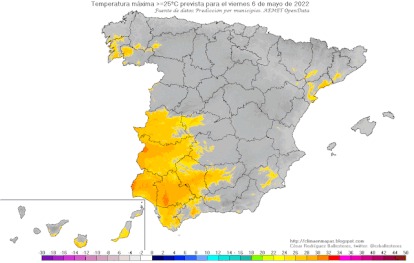
Evolution of the zones with maximum temperature >= 25° from Friday to Tuesday. CÉSAR RODRÍGUEZ BALLESTEROS / AEMET
Canary Islands;
up to 32º degrees.
This Friday and the weekend practically clear skies will predominate, with some clouds in the north of the islands of greater relief and rising temperatures until reaching a Sunday in which they can exceed 32 ° in the eastern islands.
A new intrusion of suspended dust will occur from Saturday afternoon, which will lead to haze.
Next week: add and continue.
The weather will hardly change for the next week as Spain will continue to be under the influence of high pressure.
“On Monday and Tuesday, slightly cloudy skies will predominate in general, although again with evolving clouds, especially in the northeast of the Peninsula, which can cause some scattered showers that, perhaps, will also occur in mountain areas of the peninsula. rest of the eastern half”, Del Campo glimpses.
Temperatures will continue to rise on Monday and Tuesday throughout the country, including the Canary archipelago: in Lanzarote, Fuerteventura and the south of Gran Canaria it could exceed 34°.
On Tuesday, temperatures will moderate in the Canary Islands, but will continue to rise in the rest of the country: 34° may already appear on the thermometers in the Guadalquivir and Guadiana valleys on both Monday and Tuesday.
Uncertainty increases as of Wednesday, although today it is most likely that the weather will remain stable and the environment warm, especially in the west of the peninsula.


/cloudfront-eu-central-1.images.arcpublishing.com/prisa/KMEYMJKESBAZBE4MRBAM4TGHIQ.jpg)