Hong Kong is about to enter the midsummer of July, and the typhoon season is approaching.
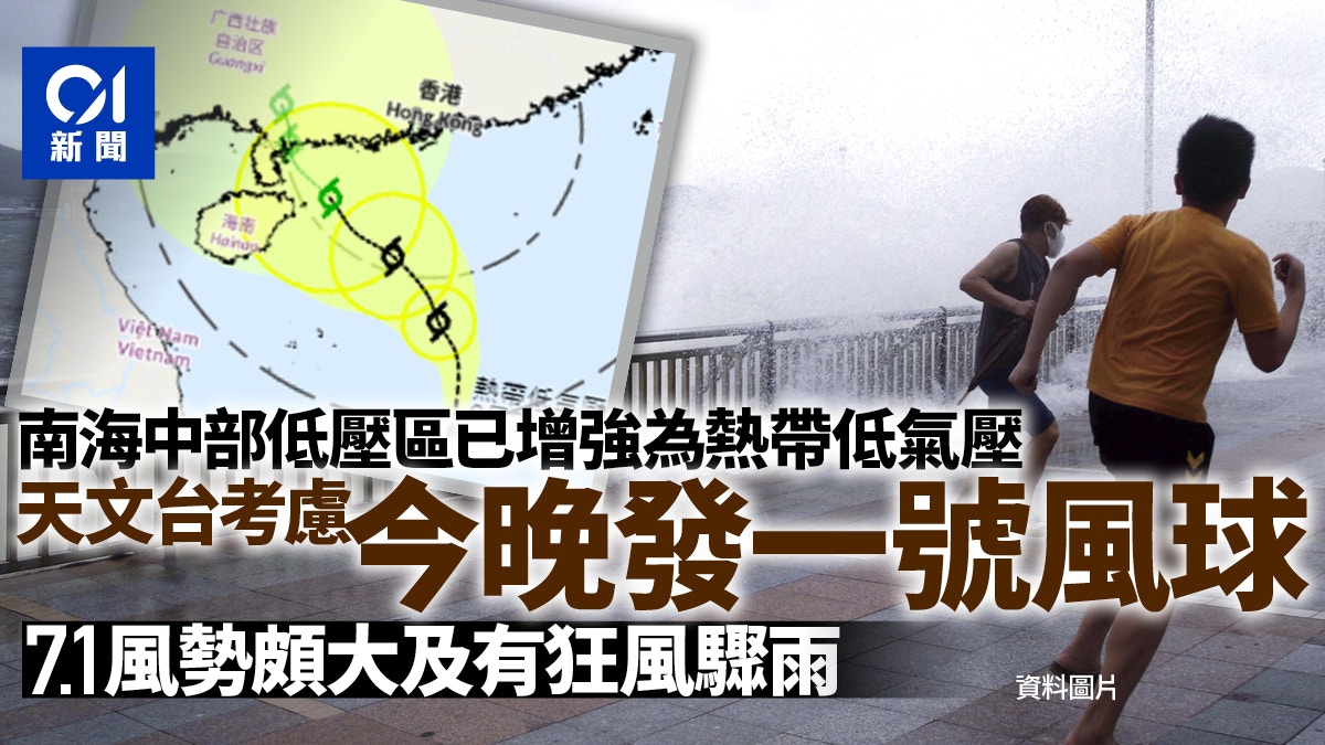
The Observatory issued a special weather warning today (29th) that the low-pressure area in the central part of the Guide Sea has intensified into a tropical depression, maintaining a distance of more than 800 kilometers from Hong Kong.
According to the current forecast path, the tropical depression will enter Hong Kong within 800 kilometers later today.
The Observatory also stated that depending on local wind changes, it will consider issuing the alert signal No. 1 tonight.
The tropical depression will generally move towards the west of Guangdong to Hainan Island in the next two to three days.
Local winds will gradually intensify and showers will increase tomorrow (30). It will be windy and squally showers on July 1.
According to the current forecast path, the tropical depression will enter Hong Kong within 800 kilometers later today.
(Screenshot from the Observatory's website)
▼On June 27, the hot weather warning came into effect, and the temperature in some New Territories reached 34 degrees▼
+3
The observatory said that the low-pressure area in the central part of the South China Sea has intensified into a tropical depression.
At 12 noon today, the tropical depression gathered about 450 kilometers east-southeast of Xisha, and is expected to move north-northwestward at a speed of about 10 kilometers per hour. Hainan Island area.
It is predicted that the wind will gradually strengthen tomorrow (30th) and there will be more showers.
It was windy with squally showers for the next day or two.
According to the track information of the Observatory, the tropical depression will enter a range of 400 kilometers in Hong Kong at 11:00 am on July 1. It will intensify into a tropical storm on July 2, and will be closest to Hong Kong. It will make landfall in the area of Zhanjiang City on July 3.
Referring to the nine-day weather forecast, it is expected that there will be more frequent showers and squally thunderstorms in Hong Kong tomorrow, with strong winds of magnitude 7 occasionally blowing in the highlands on Friday July 1, and the severe weather will continue at least until next Sunday.
▼European Centre for Medium-Range Weather Forecasts ECMWF forecast▼
▼US Global Forecast System GFS forecast▼
▼On October 13, when the typhoon compasses hit Hong Kong, some citizens went out to watch the waves▼
+1
Fighting Wind | Observatory: Considering the No. 1 typhoon tonight if it intensifies into a tropical storm, it will be named Siam Ba Taifeng | Squealing and showering around 7.1 The Observatory analyzes a variable that may not be a gust of wind | The Observatory raises the wind forecast by 7.1 and expects a cross wind The horizontal rain difference reaches the No. 8 typhoon and the wind blows. The Observatory expects the quasi-tropical cyclone to be predicted to hit Hong Kong with 7.1 squally thunderstorm 7.1 wind?
︱The Observatory predicts that there is a low pressure area in the South China Sea, and the United States forecasts that it can reach the level of a strong typhoon