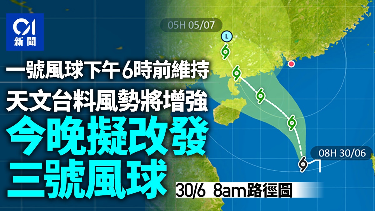
The typhoon season has begun. The Observatory said that according to the current forecast path, the tropical depression will maintain a distance of more than 500 kilometers from Hong Kong during the day today, and the wind force in Hong Kong will not increase significantly. The No. 1 alert signal will be maintained until 6 pm today.
As the tropical depression continues to approach the coast of western Guangdong, the Observatory expects local winds to gradually intensify tonight, when the Observatory will consider issuing the No. 3 Strong Wind Signal.
Standby Signal No. 1 is now in effect.
At 9 a.m., the tropical depression in the central part of the South China Sea was about 750 kilometers south of Hong Kong and was expected to move north-northwestward at a speed of about 12 kilometers per hour, generally moving toward the western coast of Guangdong.
The Observatory reminded that the outer rainbands related to the tropical depression have affected Hong Kong, and there will be swells on the sea surface. The public should stay away from the shore and stop all water activities.
According to the current forecast path, the tropical depression will be upgraded to a tropical storm tomorrow (July 1), and will gradually break into the area of 400 kilometers in Hong Kong. At that time, there will be squally showers and thunderstorms in Hong Kong. The holiday continued with squally showers and thunderstorms, and the rain was sometimes heavy.
The Macao Geophysics and Meteorological Bureau stated that the tropical depression located in the central part of the South China Sea will gradually intensify in the next one or two days, generally tending to the area from western Guangdong to Hainan Island. The probability of Typhoon No. 3 is moderate to high, and the probability of changing to Typhoon No. 8 from tomorrow night to the next morning is low to medium.
In addition, Macau is expected to be affected by the development of another low-pressure area east of the Philippines. The intensity and path of this tropical depression will still be highly variable in the future. If it adopts a more northerly path closer to Macau or strengthens near the coast, it will not be at that time. Eliminate the chance of changing a higher typhoon signal.
▼October 13, 2021 Typhoon Compass hit Hong Kong, and many citizens went out or chased the wind▼
+23
▼Market situation under Typhoon Compass on October 13, 2021 ▼
+14
The Observatory issued the first typhoon signal No. 1 this year, 2 hours later than Macau. The Observatory pointed out that the weather on 7.1 will gradually deteriorate and the wind will increase. Return to Sunrise Street and remember to bring an umbrella to play the wind | The Observatory will consider issuing the No. 1 typhoon tonight It is expected that the tropical storm will be upgraded on 7.1 and will hit the port for 400 kilometers.