Tropical Storm Siamba is gradually approaching. The Observatory issued the first typhoon signal No. 1 this year on Wednesday (29th). It is expected that Siamba will generally move towards the western coast of Guangdong in the next one or two days and gradually intensify, with strong winds blowing in the northern part of the South China Sea and the coast of southern China , its associated outer rainbands will also bring squally showers and thunderstorms to the area, and severe weather will continue to usher in this long weekend.
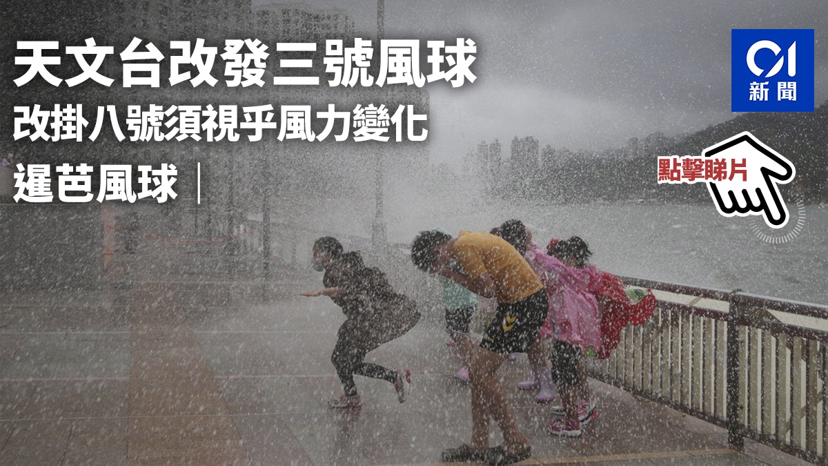
The Observatory changed the typhoon signal No. 3 at 10:40 p.m. on Thursday (30th), and pointed out that in the past few hours, Siamba continued to move in a northerly direction, gradually approaching the western coast of Guangdong, and the local winds also gradually strengthened.
At 0:50 on Friday (1st), the Observatory issued a yellow rainstorm warning.
[00:50] The Observatory issued a yellow rainstorm warning.
[00:15] The Observatory said that extensive areas of Hong Kong may be affected by heavy rain in the next hour or two, and the public should be vigilant.
As the No. 3 Tropical Cyclone Warning Signal has been issued, the Home Affairs Department has set up a 24-hour emergency hotline 2572 8427 for public enquiries.
[22:40] The local area is being affected by the rainbands outside Siamba, and the wind is gradually increasing.
The Observatory reissued the No. 3 strong wind signal at 10:40 tonight.
The Observatory pointed out that as Siam Ba is gradually approaching the western coast of Guangdong, the local wind is gradually strengthening, and strong winds are blowing offshore and highlands. The No. 3 strong wind signal will be maintained until noon tomorrow (July 1).
Whether the No. 8 Gale or Storm Signal will be issued later will depend on the development of Siamba and changes in local winds.
The Observatory will closely monitor the movements of Siam Ba.
Due to strong waves and swells, the public should stay away from the shore and stop all water activities.
In the past hour, the highest sustained wind speeds recorded at Waglan Island and Tap Mun were 53 and 50 km/h respectively, and the highest gusts were 59 and 60 km/h respectively.
The Observatory predicted that Siamba would intensify into a severe tropical storm on July 1.
According to the weather forecast report, the easterly wind is 6 to 7 on Friday, with 8 between the offshore and highlands, which is the gale force of the No. 8 typhoon.
Hong Kong will continue to blow southeasterly winds of magnitude 5 until the weekend of July 2, initially at magnitude 6, and up to level 7 in the highlands, that is, strong winds at the level of the No. 3 typhoon.
[19:45] The observatory said that in the past few hours, Siamba continued to move to the north and strengthened.
Hong Kong is under the influence of its outer rainbands, with occasional strong winds from offshore and highlands.
According to the current forecast path, Siamba will gradually approach the western coast of Guangdong, and the local wind will gradually intensify.
[18:55] Zhang Bing, senior scientific director of the Observatory, said that the weather on July 1st will further deteriorate, with strong winds, stronger winds in the highlands, and squally showers.
He also said that there is not enough data to analyze whether the No. 8 gale or storm signal will be forwarded. It is believed that "Siamba" will be closest to Hong Kong from tomorrow night to the day after tomorrow, when the intensity and actual path will become clearer.
[18:50] Alert Signal No. 1 is now in effect.
The Observatory predicts that at 7 p.m., Tropical Storm Siamba will be concentrated about 630 kilometers south of Hong Kong, and is expected to move north-northwestward at a speed of about 15 kilometers per hour, generally moving towards the western coast of Guangdong.
Over the past few hours, Siamba has continued to move northerly and its associated outer rainbands are affecting Hong Kong.
According to the current forecast path, as Siamba gradually approaches the western coast of Guangdong and strengthens slightly, the local wind will gradually strengthen tonight, and there will be swells on the sea surface. The Observatory will change the strong wind signal No. 3 before midnight.
[16:55] The Observatory stated that Tropical Storm Siamba is expected to gather about 650 kilometers south of Hong Kong at 5 pm, and will move north-northwestward at a speed of about 15 kilometers per hour, generally moving towards the western coast of Guangdong.
The Observatory predicts that Siamba will generally move to the western coast of Guangdong in the next one or two days, and gradually strengthen. It is expected that there will be squally showers and thunderstorms tomorrow during the July 1st holiday. wave.
According to the current forecast path, the maximum sustained wind speed near the center of Siamba will reach 75 kilometers per hour tomorrow, and it will intensify to 85 kilometers per hour the next day. It will make landfall in Zhanjiang City on the same day.
▼October 13, 2021 Typhoon Compass hit Hong Kong with wind and rain, and some citizens went out to watch the waves▼
+1
▼On June 27, the hot weather warning came into effect, and the temperature in some New Territories reached 34 degrees▼
+3
Siamba typhoon | Observatory expects tropical storm 7.1 to break into Hong Kong for a 400-kilometer long weekend to face squally thunderstorms Siamba typhoon | Siamba typhoon moves closer and intensifies as a tropical storm Observatory plans to change to No. 3 typhoon to hit the wind?
|Hong Kong’s first typhoon signal No. 1 takes effect this year, Macau is forecast to dance with a double spin or change its path to hit the wind|The Observatory says the weather will gradually turn bad on 7.1 and the wind will increase