
Severe Tropical Storm Siam is approaching on July 1, and the No. 3 strong wind signal is now in effect.
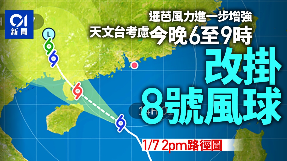
The Observatory expects that Siemba will intensify, and the associated gale area will be close to the Pearl River Estuary later today, and the wind will further strengthen in the general area of Hong Kong. Consider changing the No. 8 gale or storm signal from 6:00 to 9:00 tonight.
The Macao Geophysics and Meteorological Bureau stated that the possibility of changing the No. 8 typhoon from this afternoon to the evening is medium. If Siamba adopts a more northerly path closer to Macao or strengthens near the coast, it is not ruled out that a higher typhoon will be issued at that time. Chance.
▼On July 1st, the No. 3 strong wind signal took effect, strong winds and heavy rain in various districts▼
[15:15] The Observatory issued another yellow rainstorm warning signal, indicating that heavy rain with an hourly rainfall exceeding 30 mm per hour has been recorded or expected in a wide area of Hong Kong, and the rain may continue.
[14:45] The Observatory said that in the past few hours, Siamba continued to move northwestward, and its associated rainbands occasionally brought heavy showers and violent gusts to the coast of Guangdong. Strong winds were generally blowing in Hong Kong, and the south was stronger.
According to the current forecast path, Siamba will be closest to Hong Kong from tonight to tomorrow morning, passing around 300 kilometers southwest of Hong Kong. Siamba is expected to intensify, and the associated gale area will be close to the Pearl River Estuary later today. The regional wind will further strengthen, and the Observatory will consider changing the No. 8 Gale or Storm Signal from 6:00 to 9:00 tonight.
In the past hour, the highest sustained wind speeds recorded at Waglan Island and Cheung Chau Beach were 70 and 62 km/h respectively, and the highest gusts were 81 and 75 km/h respectively.
At 3 p.m., Severe Tropical Storm Siamba gathered about 390 kilometers south-southwest of Hong Kong, and was expected to move northwestward at a speed of about 18 kilometers per hour, generally moving towards the western coast of Guangdong.
[14:30] In the next one or two hours, extensive areas of Hong Kong may be affected by heavy rain, and the public should be vigilant.
[13:45] Strong wind signal No. 3 is now in effect.
The Observatory said that Siamba continued to move northwestward in the past few hours, and its associated rainbands occasionally brought heavy showers and violent gusts to the coast of Guangdong. Strong winds were generally blowing in Hong Kong, and the winds were stronger in the south.
According to the current forecast path, Siamba will maintain a distance of more than 300 kilometers from Hong Kong most of the time today, and the No. 3 strong wind signal is expected to remain before 5 pm.
Whether or not the No. 8 Gale or Storm Signal will be issued later will depend on the development of Siamba and changes in local winds.
In the past hour, the highest sustained wind speeds recorded at Waglan Island and Cheung Chau Beach were 76 and 70 km/h respectively, and the highest gusts were 95 and 95 km/h respectively.
▼On June 30, the tropical cyclone Siamba was approaching on the eve of the July 1st return▼
[12:00] The Observatory issued a special weather warning, stating that an outer heavy rain belt in Siamba is approaching Hong Kong from the east, and it is expected to bring strong winds and showers to Hong Kong in the next one or two hours. The public is urged to be vigilant.
Macao Meteorological Bureau: Consider whether it is necessary to issue Typhoon No. 8 at the earliest in the evening
[11:53] The Macao Geophysics and Meteorological Bureau stated that Severe Tropical Storm Siamba moved to the northwest, generally heading towards the western part of Guangdong, and was closest to Macao from this evening to the morning of tomorrow (2nd).
As Siam Ba is gradually strengthening and may further develop into a typhoon, and Si Ba may take a more northerly path closer to Macau, the wind may reach the lower limit of Typhoon No. 8 at that time, depending on its development and wind changes. Consider whether a No. 8 typhoon signal needs to be issued in the evening to early morning.
According to the current forecast, Macau has a moderate to high probability of changing the signal of Typhoon Signal No. 8 from tonight to the early morning of the next day.
The Macao Geophysics and Meteorological Bureau stated that the probability of the local typhoon No. 8 issued from this evening to the early morning of the next day is moderate to high.
(Photo from the website of the Macao Geophysics and Meteorological Bureau)
Hong Kong Observatory: Whether Typhoon Signal No. 8 will be reissued depends on the development of Siemba and changes in local winds
[11:45] The No. 3 strong wind signal is now in effect.
The Observatory said that at 12 noon, Severe Tropical Storm Siamba is expected to gather about 410 kilometers south of Hong Kong, and is expected to move northwest at a speed of about 18 kilometers per hour, generally moving towards the western coast of Guangdong.
In the past few hours, the Siemba-related rainbands occasionally brought heavy showers and violent gusts to the coast of Guangdong. Strong winds were generally blowing in Hong Kong, with stronger winds in the south.
According to the current forecast path, Siamba will maintain a distance of more than 300 kilometers from Hong Kong most of the time today, and the No. 3 strong wind signal is expected to remain before 5 pm.
Whether the No. 8 Gale or Storm Signal will be issued later will depend on the development of Siamba and changes in local winds.
In the past hour, the highest sustained wind speeds recorded at Waglan Island and Cheung Chau Beach were 73 and 60 km/h respectively, and the highest gusts were 84 and 80 km/h respectively.
[11:00] The No. 3 strong wind signal is now in effect.
The Observatory said that the average wind speed in Hong Kong is expected to be 41 to 62 kilometers per hour.
At 11:00 am, Severe Tropical Storm Siamba gathered about 430 kilometers south of Hong Kong and is expected to move northwestward at a speed of about 18 kilometers per hour, generally moving towards the western coast of Guangdong.
In the past hour, the highest sustained wind speeds recorded at Ngong Ping and Waglan Island were 76 and 68 kilometers per hour respectively, and the highest gusts were 100 and 77 kilometers per hour respectively.
[10:00] At 10:00 am, Severe Tropical Storm Siamba gathered about 440 kilometers south of Hong Kong and is expected to move northwestward at a speed of about 18 kilometers per hour, generally moving towards the western coast of Guangdong.
In the past few hours, Siamba continued to move northwestward, and its associated rainbands occasionally brought heavy showers and violent gusts to the coast of Guangdong. Strong winds were generally blowing in Hong Kong, and the winds were stronger in the south. The No. 3 Strong Wind Signal will be issued before 5:00 p.m. maintain.
Whether the No. 8 Gale or Storm Signal will be issued later will depend on the development of Siamba and changes in local winds.
In the past hour, the highest sustained wind speeds recorded at Ngong Ping, Waglan Island and Cheung Chau Beach were 70, 68 and 55 km/h respectively, and the highest gusts were 95, 75 and 68 km/h respectively.
The Observatory said that strong easterly winds were blowing in Hong Kong today, with occasional gale force winds from offshore and highlands, cloudy with squally showers and thunderstorms, and the rain was sometimes heavy.
Tropical Cyclone Siamba will generally move towards the western coast of Guangdong today and tomorrow, and will gradually intensify. Strong winds will blow in the northern part of the South China Sea and the coast of southern China, and there will be swells in the sea. thunderstorm.
Macao Meteorological Bureau: There is a medium chance of changing the typhoon signal No. 8
The Macao Geophysics and Meteorological Bureau stated this morning that Severe Tropical Storm Siamba will move to the northwest, generally heading towards the western part of Guangdong to Hainan Island.
As it is expected to be affected by the development of another low-pressure area east of the Philippines, its intensity and path will still be subject to great uncertainty in the future. For example, if Siemba adopts a more northerly path closer to Macau or strengthens near the coast, it is not ruled out that a higher typhoon will be issued at that time. Opportunity.
According to the predicted path of Macau, Siamba will be upgraded to a typhoon tomorrow (2nd).
Due to the astronomical spring tide in the next few days, there will be slight flooding in the inner harbour area from morning to noon in Macau. Under the influence of superimposed storm surges and continuous rainfall, it is predicted that water below 0.5 meters will appear in the inner harbour area from morning to noon tomorrow. dip.
The Macao Geophysics and Meteorological Bureau predicts that there is a medium chance of the local typhoon No. 8 from this afternoon to evening.
(Photo from the website of the Macao Geophysics and Meteorological Bureau)
▼On June 30, when Tropical Cyclone Siamba hit Hong Kong, some citizens still went to Shek O for surfing▼
+7
▼October 13, 2021 Typhoon Compass hit Hong Kong, and many citizens went out or chased the wind▼
+23
Siam Ball.
Multiple pictures|Double rainbows suddenly appear in various districts under the typhoon The reason for the dismantling of the Observatory in Siamba|The name of the Siamba typhoon is provided by Thailand, a kind of common plant in Hong Kong that hit Korea in 2016. Smashing Thunderstorm Siamba Typhoon Signal Over the Long Weekend | Siamba Moves Closer and Intensifies into Tropical Storm Observatory to issue Typhoon Signal No. 3 tonight


/cloudfront-eu-central-1.images.arcpublishing.com/prisa/M52GR73B3X2YKMRHEEKK6PJ45Y.jpg)


/cloudfront-eu-central-1.images.arcpublishing.com/prisa/KMEYMJKESBAZBE4MRBAM4TGHIQ.jpg)

