
A NASA satellite has focused the objective on Mexico and has portrayed the conditions of the Cerro Prieto dam in the northern state of Nuevo León.
The result is impressive and reveals the severity of the drought that the entire north of Mexico has suffered in recent weeks.
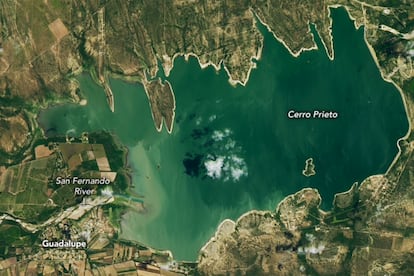
The photographs show the reservoir practically empty: the data obtained with the Landsat 8 satellite image estimate that the dam is at 0.5% of its capacity.
The water levels have never dropped so low since its construction in 1980.
Cerro Prieto is one of two dams that feed the Monterrey metropolitan area—the second largest in Mexico, after the capital—and its deterioration has left residents of the region with little or no water supply.
The crisis deepened at the beginning of July with the rise in temperatures that reached up to 40 degrees Celsius.
"The water levels fell so much in Cerro Prieto that the water could no longer be extracted," NASA explained in a statement.
Satellite view of the Cerro Prieto dam, located in Nuevo León, on July 7, 2022.NASA
The water crisis in Nuevo León has reached its most critical point, despite warnings.
The local government noted last October that the dam's capacity was at 12%, by early June it was already at 2.7%.
The situation has begun to generate tensions among the inhabitants of the region and has opened the debate on the use of water for industry and agriculture, in a highly productive region for these sectors.
Although some sporadic rains have led Neolonese officials to say that water extraction from the dam could resume in August, satellite images captured on July 7 suggest that Cerro Prieto is at its most critical moment.
At the end of June 2022, explains the NASA report, two thirds of Mexico were affected by the historic drought, impacting 21 million people.
Satellite exploration has allowed experts to measure the impact of the drought in the border region between Mexico and the United States.
According to their data, 45% of the State of Texas is experiencing extreme drought;
New Mexico suffers from it in 60% of its territory;
Chihuahua has been affected by 25%;
and Coahuila by 33%.
Satellite view of the Cerro Prieto dam, in Nuevo León, on July 20, 2015.NASA
subscribe here
to the
newsletter
of EL PAÍS México and receive all the informative keys of the current affairs of this country