Heat waves are not only terrestrial, they are also suffered by the seas and oceans.
Meteorologists affirm that a very harsh storm is taking place in the Mediterranean, "with temperatures between 28° and 30°, up to 5° above normal values," explains Rubén del Campo, spokesman for the State Meteorological Agency (Aemet). ).
This intense heat multiplies the tropical and equatorial nights on the coast —in which it does not drop below 20° and 30°—, endangers marine habitats and stirs up fear of torrential rains in Levante.
But experts explain that, although a sea that is too warm is a “bomb”,
what is decisive are atmospheric factors such as a dana —a pocket of air in the upper layers popularly known as a cold drop— or a trough —an area of low pressure in the upper layers in the shape of a tongue and cold air within it—.
That is to say, the fuel is there, but the fuse is missing.
🌊 MARINE HEAT WAVE |
In recent weeks, high temperature values are being recorded in the #Mediterranean sea.
What criteria is used to talk about a marine heat wave?
@Armeteo explains it to us.
@rtvenoticias pic.twitter.com/QW7yUziYbX
– Weather on TVE (@ElTiempo_tve) July 26, 2022
It is not easy to determine what a marine heat wave is.
“There is no criterion like in the atmospheric ones, in which thresholds of intensity, duration and extension have to be exceeded.
They are defined as episodes of high temperatures that can last days, weeks or months”, Del Campo contextualizes.
Marc Santandreu, TVE meteorologist, clarifies that "temperatures have to exceed the 90th percentile for several days".
“The sea has been heating up little by little like a pot because there was a very strong heat episode in May, a powerful and premature wave in June and now, the most intense.
Although the sea has thermal inertia, in the end it is contaminated by all this heat, especially when there are no strong winds and the situation is stable, as it has been happening all summer”, explains Santandreu.
"Being a sea, it is very sensitive to atmospheric conditions, so the succession of persistent heat episodes impact it," adds atmospheric dynamics researcher Juan Jesús González Alemán.
Samuel Biener, climatologist at Meteored and the University of Alicante, calculates that it began at the end of May or beginning of June, when the water temperature was already 25°, while warning that the frequency of this phenomenon is increasing.
According to Santandreu, it is due "to global warming, since higher global temperatures cause higher temperatures in the sea."
And, as is the case with the terrestrial ones, the marine ones are now more powerful in an already overheated Mediterranean, indicates González Alemán.
"It is a hot spot of global warming, an outpost where its effects are seen more clearly than in the oceans," lamented this researcher.
Although the wave "has been dragging on since May", González Alemán clarifies that it has been varying in intensity and in the most affected areas.
Right now, Del Campo points out, the worst is concentrated in the "western basin, from Italy to the Iberian Peninsula", where the greatest anomalies are suffered, between 3° and 5°, especially from Sardinia to the Balearic Islands, from 4 ° to 5 °, according to satellite data.
In Barcelona it is 3rd.
"The closest antecedent of a similar range" was 2017, although it may also be on a par with 2003, the hottest summer so far.
Biener specifies that, at the moment, it has a somewhat lower intensity, since in 2003 they measured 31° in the Balearic Islands.
The Puertos del Estado buoys confirm the values of the satellites.
Marta de Alfonso, head of Climatic Data of the organism, specifies that Cabo de Gata (Almería) "beat the absolute record on Monday, with 27.9 °".
Two other buoys have registered their maximum for June, that of Dragonera (Balearic Islands), with 29.4° on the 18th ―its absolute is from 2018, 31.2°― and that of Valencia, with 26.9° on the 20th ― its absolute is 28.6° in 2015―.
In addition, a coastal buoy, that of Tarragona, marked monthly maximums in May (24.1°) and June (27.8°).
Its highest level is from 2013, with 30.5°.
De Alfonso warns that “there is still a lot of summer left and it is foreseeable that there will be higher values”.
The worst, indeed, is yet to come.
"The maximum occurs in mid-August, so if the dynamic continues as it seems, historical records can be produced," warns Santandreu.
Temperature of the buoys on the Puertos del Estado website.
The panic that this boiling soup will produce torrential rains this fall in Mediterranean communities has skyrocketed, especially after a tweet by meteorologist Mario Picazo in which he established a direct relationship.
However, Del Campo stresses that "it does not have to happen", since "no matter how hot the sea is, if the appropriate atmospheric conditions such as danas or troughs are not met, not a drop will fall".
A warmer sea translates into "greater availability of moisture" and into a "powerful source of stored energy", that is, into "a time bomb", but if there is no detonator,
“nothing will happen”.
Thus, an abnormally warm Mediterranean is "a necessary ingredient, but not a determining one", says José Ángel Núñez Mora, head of Climatology at Aemet Comunidad Valenciana, who recalls that "it reached temperatures close to 30° in August 2017 and that autumn was extremely dry” in the region, a pattern “repeats frequently”.
In fact, “the classic period of torrential rains does not occur when the sea is warmest, but in September or October, when it falls.
It is because the troughs and danas occur from September”.
But "sometimes they occur at the end of summer," recalls Del Campo, as in the floods in Toledo on August 31 last.
A very warm sea is not synonymous with torrential rains.
Yes, from a greater amount of energy in reserve, although without a favorable atmospheric configuration we cannot guarantee anything.
The damage to ecosystems or the increase in torrid nights are attributable to a #OlaDeCalorMarina pic.twitter.com/KkqmoHXcDH
– Marc Santandreu (@marcsansa) July 25, 2022
For Biener, a peculiar “Holy Trinity” is required: pockets of cold air in height ―but not only, because “the Mediterranean is becoming tropical and warm rains typical of tropical seas are produced at the end of summer”―;
very humid wind inputs coming from the sea ―as happened in the floods in Germany last year―;
and heat in the sea, which is the least decisive aspect”.
“Right now, only one of the actors is given”, he points out to the relief of the Levantines, although he warns that the season of cold drops “is extending to spring and winter due to the extra heat from the sea”.
Santandreu also assures that “the potential increase in the energy stored and remaining in the sea is not synonymous with torrential rains, unless a favorable atmospheric configuration is created.
The last word has the atmosphere”.
"It's a powder keg, it's gasoline, but without the spark, the fuel will disappear," he hopes.
"An extraordinarily warm sea does not have to lead to a torrential autumn, but it does add more ballots to the lottery, so that, if the atmospheric situation occurs, they are more explosive and intense," warns González Alemán.
The problem is that danas are impossible to forecast in the long term.
“We don't know if this fall is going to be a season with high-impact danas.
We can only see that one approaches Spain at 7/10 days ahead and its trajectory at 3/4″.
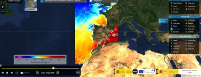
Spectacular surface water temperature anomalies in the Mediterranean Sea.
They would meet the requirements to qualify it as a marine #HeatWave, disastrous for the marine ecosystem.
And we will be aware of how it will affect DANAs and floods in the fall... pic.twitter.com/ZjFgc0ZTzZ
– JJ González Alemán (@glezjuanje) July 25, 2022
González Alemán also warns that such a warm sea “adds the potential for tropical cyclones to develop in the Mediterranean”, the medicanes.
“It is increasingly likely that a real hurricane will develop in the Mediterranean, the one in 2020 in Greece was quite similar.
They will not be category 5, but they will be 1/2, which can have a very notable impact on poorly prepared and highly populated coasts.”
What is already happening is the increase in tropical and torrid nights in Almería, the Valencian Community, Murcia and Catalonia.
"The seas and oceans are natural thermostats that produce milder winters and summers," says Del Campo, but with this Mediterranean consommé, "coastal areas get less cold at night."
"This is the most short-term and visible consequence, the total cessation of night cooling," adds Santandreu.
Tuesday's minimum was the warmest so far at the Valencia observatory (Viveros), 27°.
In 2022, Valencia has already 52 tropical nights, Núñez figure.
Europe is not just experiencing heatwaves on land.
The Mediterranean Sea is experiencing a brutal marine heatwave this July, which will have devastating impacts on marine ecosystems while also enhancing heatwaves on land.
Water temperatures are as high as 6.2°C above normal!
pic.twitter.com/AFqSz6BEMD
— US StormWatch (@US_Stormwatch) July 23, 2022
Another no less important derivative is the impact on marine flora and fauna.
"The Intergovernmental Panel on Climate Change (IPCC) already warned in 2019 that marine heat waves are very harmful to coral ecosystems and fish fauna," says the Aemet spokesman, to add that in the of 2003 "produced significant damage to the fauna of micro-individuals", key in the food chain and whose reduction can reduce fishing resources.
In addition, indicates Santandreu, in the long term it can cause migrations, "the most thermosensitive species will want to escape from the heat and the tropical ones, to arrive".
"Some immobile species, such as corals, are already being lost and proof of their resilience is that they generate fluorescent pigments to take their last breath before dying."
The native species "will be displaced by invasive species that slip through the Suez Canal from the Red Sea, whose temperature is equating to the Mediterranean," adds Biener, who explains that "the metabolism of the fish is being altered, which they become disoriented and approach the coast.”
In Alicante, there have been bites by obladas, fish that live in depths of 5 to 20 meters.
"Its effect on posidonia meadows is also very serious, which is increasingly subjected to greater thermal stress, which is altering its life cycle and causing its regression."
Posidonia generate more oxygen than the Amazon and help mitigate the effects of climate change.
You can follow CLIMA Y MEDIO AMBIENTE on
and
, or sign up here to receive
our weekly newsletter