
[Qianxi Festival/Typhoon/Typhoon/Wind/Observatory/Tropical Depression] An unnamed tropical depression (tropical cyclone level 1) suddenly formed in the northern part of the South China Sea last afternoon (3rd) at the Observatory at 10 p.m. The No. 1 typhoon broke out at 10 minutes. It is predicted that today (4th, the seventh day of the seventh month of the lunar calendar) will gradually approach Hong Kong from day to night. The local wind will strengthen around noon today, and the No. 1 typhoon will remain at least until morning. 10 am.
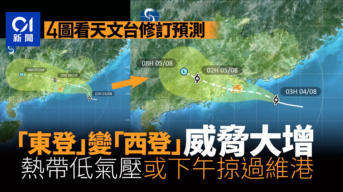
According to the predicted movement path map issued by the Observatory at 8 o'clock last night, it is expected that the tropical depression will make landfall in Shenzhen's Daya Bay area this afternoon, that is, "East Deng"; The waters south of Hong Kong swept across, and then moved to Macau and Hengqin to the west of the Pearl River Estuary. After that, it was fine-tuned at 4 am today. It is expected that the tropical depression will follow a path closer to Hong Kong, about 15% closer than before. Kilometers are equivalent to the east-west distance of Hong Kong Island.
According to the latest forecast at 5 am this morning, a tropical depression may even pass over the Victoria Harbour in the afternoon.
If the tropical depression finally hits westward and is very close to Hong Kong, the threat to Hong Kong will be very different from the original forecast of eastward landing. Because the wind force on Hong Kong will not weaken significantly, the southeast wind will push the sea water to the shore, causing a storm tide.
▼The Observatory issued a yellow rainstorm warning on August 3▼
+3
It is predicted that Dongdeng will land in Daya Bay at 8:00 p.m. on August 3
From the predicted path map issued by the Observatory at 8 pm on August 3, it can be seen that the tropical depression is expected to move northward first, then turn northwestward and move towards Daya Bay, Shenzhen. It will land about 60 kilometers east of the Tsim Sha Tsui Observatory and then pass Shenzhen. And Dongguan, moving to Guangzhou, it will be a tropical cyclone eastward.
According to the forecast path map issued by the Observatory at 8 p.m. on August 3, it is expected that the tropical depression will first move northward, then turn northwesterly, and make landfall in the Shenzhen Daya Bay area, about 60 kilometers east of Hong Kong, and will land eastward.
(Photo from the Observatory)
At about 11:30 p.m. on August 3, the forecast was changed to pass by about 50 kilometers south of Sidon Hong Kong
The Observatory updated the forecast path map at about 11:30 last night. It is very different from the forecast at 8:00. The heat will move directly westward, and it will move to the Wanshan Islands in the waters south of Hong Kong, then move to the Wanshan Islands, and then cross the Pearl River Estuary. , tending to Macau and Hengqin Island, roughly 50 kilometers south of the Observatory, that is, it will meet Sidon.
Landfall west of Hong Kong could bring storm surge
The Observatory has pointed out many times that a tropical cyclone makes landfall in the east or west of Hong Kong, and the impact on the weather in Hong Kong can be very different.
If it makes landfall in the east of Hong Kong, the northerly wind blows in Hong Kong for a period of time, and is blocked by the mountains, and the wind force is relatively low; but if it passes over the south of Hong Kong and makes landfall in the west of Hong Kong, the wind force in Hong Kong will not be significantly weakened, and the southeast wind will be stronger. It pushes the water towards the shore, creating a storm surge.
The Observatory updated the forecast path map at about 11:30 p.m. on August 3. It is expected that the tropical depression will move directly to the west and will pass from the Tangan Islands to the Wanshan Islands, about 50 kilometers south of the Observatory, and then cross the Pearl River Estuary towards Macau. And Hengqin Island, that will be Siddon.
(Photo from the Observatory)
At 4:00 a.m. on August 4th, Siddon was fine-tuned to predict that it would be closer to Hong Kong by 15 kilometers
The forecast path map issued by the Observatory at 4:00 a.m. on August 4 has been fine-tuned. Although it is still predicted that it will pass through the inland waters south of Hong Kong, it is closer to Hong Kong by about 15 kilometers than the forecast of Sidon in the early morning, shortening the distance. Equal to Mount Davis on Hong Kong Island to Siu Sai Wan, Po Toi Island, Lamma Island, Cheung Chau, Sok Kwu Islands and the south of Lantau Island to the south will be quite close to a tropical depression, it is unknown whether the eye will pass; Cross the Pearl River Estuary and land in Macau.
The Observatory updated the forecast path map again at 4:00 am on August 4, maintaining the Sidden forecast, but making minor adjustments. It is expected that the tropical depression will adopt a new path to move closer to Hong Kong, and then approach Hong Kong for about 15 kilometers, passing Lantau Island to Kwai Shan Island in the south, and Cheung Chau, Lamma Island and Po Toi Island in the south of Hong Kong will be fairly close to tropical depressions.
(Photo from the Observatory)
At 5:00 a.m. on August 4, it was revised and passed through the Victoria Harbour and moved westward via North Lantau.
The Observatory updated the forecast path map again at 5:00 a.m. on August 4. It is expected that the tropical depression will be closer to Hong Kong and may make landfall in Hong Kong. The eye of the wind will pass through Victoria Harbour, and then enter the Pearl River Estuary through northern Lantau Island and make a second landing in Zhuhai. .
(Photo from the Observatory)
The Observatory updated the forecast path map again at 5:00 a.m. on August 4. It is expected to be closer to Hong Kong. The tropical depression may make landfall in Hong Kong. The eye of the wind will pass through the Victoria Harbour, and then enter the Pearl River Estuary through the northern part of Lantau Island, and make a second landing in Zhuhai.
(Photo from the Observatory)
▼On July 2, Typhoon Siamba hit the seaside of Xinghua Village in Hong Kong▼
+7
The wind strengthened around noon, and the No. 1 typhoon remained until at least 10 a.m.
The storm news released by the Observatory at 4:45 a.m. stated that the tropical depression was about 130 kilometers east of Hong Kong and was expected to move west-northwestward at a speed of about 20 kilometers per hour, close to the Pearl River Estuary.
The highest sustained wind speed near its center is 45 kilometers per hour, and it is still far from intensifying into a tropical storm (winds of more than 63 kilometers per hour).
The Observatory said that in the past few hours, the tropical depression has moved steadily westward. As it continues to approach the Pearl River Estuary, the local winds will strengthen around noon today.
Standby Signal No. 1 will remain in place until at least 10 a.m. today, unless the tropical depression strengthens significantly.
The outer rainbands associated with the tropical depression will continue to bring squally heavy showers and thunderstorms to the coast of Guangdong today.
▼ECMWF forecasts the trend and intensity of tropical cyclones▼
+1
When a tropical cyclone is concentrated in a specific area, the prevailing wind direction on Waglan Island is different, and the observatory uses this to determine the wind direction.
(Observatory website)
The Observatory predicts that the north to northwest wind will gradually turn to the south today
The Observatory updated the nine-day weather forecast at 8 o'clock last night. The forecast is cloudy today, with squally showers and thunderstorms. The rain is sometimes heavy, and there are swells on the sea surface. To the southeast wind, the offshore wind reaches the level of strong wind (level 6), that is, the wind force of the No. 3 typhoon.
The nine-day weather forecast issued by the Observatory at 8 pm on August 3.
The nine-day weather forecast issued by the Observatory at 5:00 a.m. today has also been changed. The weather forecast is very poor today, but it has been changed to a gentle breeze (level 4 to 5) from the north to the northwest wind, gradually turning to the southerly wind, and the offshore wind is also intermittent. Strong wind (level 6) level, namely No. 3 typhoon wind.
The nine-day weather forecast issued by the Observatory at 5 a.m. on August 4.
Another tropical cyclone may affect Hong Kong next week
The Observatory said that as the tropical cyclone moves away, showers will decrease in the area next Sunday and Monday (7th and 8th).
Before a wind arrives, the Observatory expects another low-pressure area to bring unstable weather to the South China Sea in the early to mid-next week, and may develop into a tropical cyclone, but its path and intensity are variable.
▼The Observatory issued a yellow rainstorm warning on August 3▼
+3
▼The day before the Observatory issued a yellow rainstorm warning on August 3 was cloudy and hot▼
+5
Double typhoons | No. 1 typhoon burst out from the observatory, expected tropical depression on Thursday night Recent Hong Kong weather traffic | Tropical depression moves closer to No. 1 alert signal and maintains wind at least until 10 a.m. | Mainland Meteorological Observatory highlights tropical cyclone path on Thursday The observatory passes 50 kilometers northeast of the observatory, and the summer heat is predicted to extend to October. Global warming will cause high temperature and rainfall. The observatory predicts that there will be heavy showers and thunderstorms in the next two to three days. There may be tropical cyclone rainstorms in the beginning of next week | The observatory once issued yellow rain Warning that Wong Tai Sin, Kowloon City, Sai Kung may reach the level of black rain