[Typhoon/Typhoon/Wind/Tanabata/Observatory/Tropical Depression] The Observatory broke out the No. 1 typhoon at 10:10 last night (3rd), and the tropical depression was predicted today (4th, the seventh day of the seventh lunar month) Evening) gradually approaching Hong Kong from day to night, local winds will strengthen around noon today, and Typhoon No. 1 will remain at least until 2 pm.
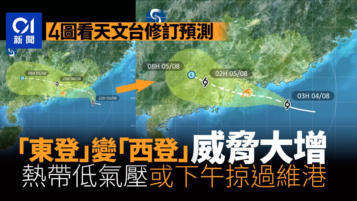
The Observatory's latest track forecast this morning is that a tropical depression will make landfall near Hong Kong in the next few hours and may pass over Victoria Harbour in the afternoon.
▼The Tanabata Typhoon Observatory has revised the forecast of the movement path of the tropical depression for many times▼
▼ECMWF forecasts the trend and intensity of tropical cyclones▼
+1
According to the Observatory's latest forecast this morning, according to the current forecast path, the tropical depression will make landfall near Hong Kong in the next few hours.
The local wind will gradually turn southerly, and some of the previously shielded areas will become windy.
Standby Signal No. 1 will remain in place until at least 2pm unless winds generally strengthen in Hong Kong.
The outer rainbands associated with the tropical depression will continue to bring squally heavy showers and thunderstorms to the coast of Guangdong today.
The Observatory predicts that the north to northwest wind will gradually turn to the south today
The nine-day weather forecast issued by the Observatory at 5:00 a.m. today has also been changed. It is predicted to be cloudy today, with squally showers and thunderstorms. The rain is sometimes heavy, and there are swells on the sea surface. The wind gradually turned to the southerly, and the offshore wind also occasionally reached the level of strong wind (level 6), that is, the wind force of the No. 3 typhoon.
The nine-day weather forecast issued by the Observatory at 5 a.m. on August 4.
Another tropical cyclone may affect Hong Kong next week
The Observatory said that as the tropical cyclone moves away, showers will decrease in the area next Sunday and Monday (7th and 8th).
Before a wind arrives, the Observatory expects another low-pressure area to bring unstable weather to the South China Sea in the early to mid-next week, and may develop into a tropical cyclone, but its path and intensity are variable.
▼On July 2, Typhoon Siamba hit the seaside of Xinghua Village in Hong Kong▼
+7
▼The Observatory issued a yellow rainstorm warning on August 3▼
+3
▼The Observatory issued a yellow rainstorm warning on August 3▼
+3
▼The day before the Observatory issued a yellow rainstorm warning on August 3 was cloudy and hot▼
+5
Double typhoons | No. 1 typhoon burst from the Observatory, a tropical depression expected on Thursday night, the latest Hong Kong Tanabata weather traffic | Tropical cyclone approaching the Observatory, No. 1 typhoon expected to maintain at least 2 p.m. | Mainland Meteorological Observatory highlights tropical cyclone path on Thursday The observatory passes 50 kilometers northeast of the observatory, and the summer heat is predicted to extend to October. Global warming will cause high temperature and rainfall. The observatory predicts that there will be heavy showers and thunderstorms in the next two to three days. There may be tropical cyclone rainstorms in the beginning of next week | The observatory once issued yellow rain Warning that Wong Tai Sin, Kowloon City, Sai Kung may reach the level of black rain

/cloudfront-eu-central-1.images.arcpublishing.com/prisa/3I74UEXLYRBBRPGPSGWNN6WXH4.jpg)