
Cabo San Lucas, in the state of Baja California Sur, Mexico.
(Photo: DANIEL SLIM/AFP via Getty Images)
(CNN Spanish) --
Tropical storm Howard formed on Sunday afternoon in the Mexican Pacific, almost 600 kilometers off the coast of Cabo San Lucas, in the state of Baja California Sur, according to the National Meteorological Service (SMN). ) from the country.
"At 4:00 p.m. Central Mexico time, Tropical Depression Nine-E intensified into Tropical Storm Howard, located approximately 595 kilometers (km) south of Cabo San Lucas, Baja California Sur, and 695 west-southwest of Manzanillo, Colima," the SMN said in a statement on Sunday.
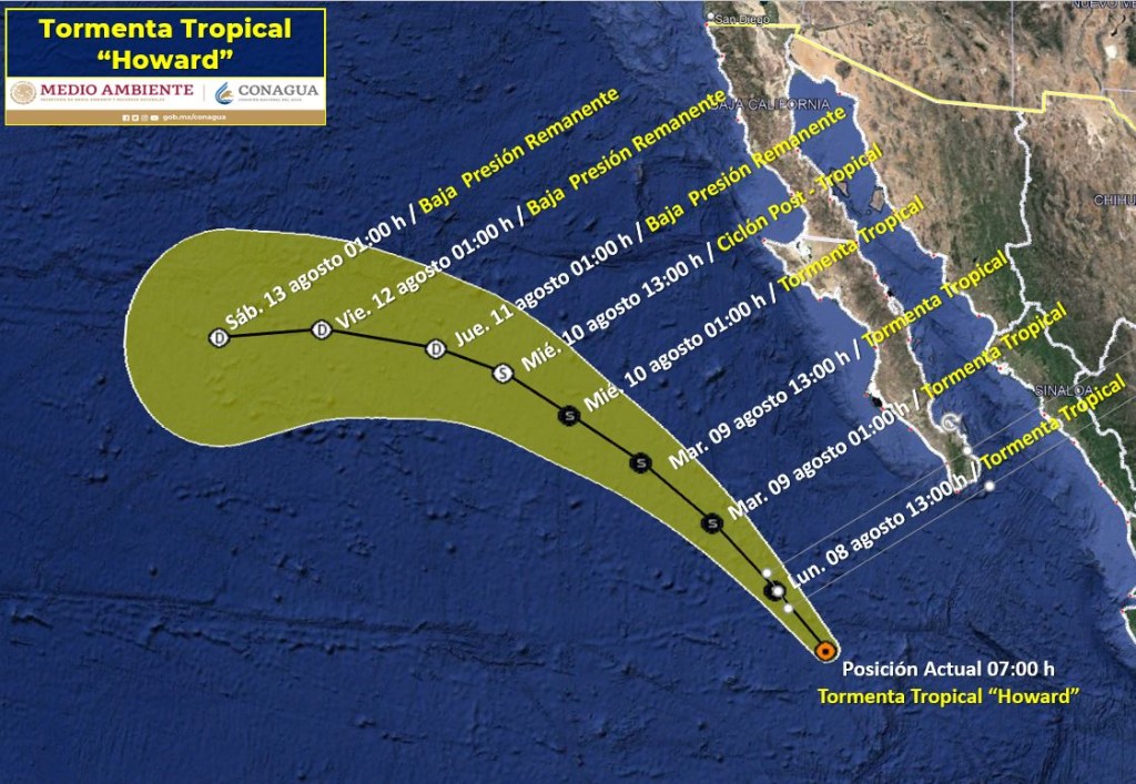
According to the SMN, the situation of Howard until 7:15 am (local time) on Monday is that the meteorological phenomenon continues its advance towards the Pacific Northwest, at a speed of 22 km / hour.
Howard was located until Monday morning at 495 km from Cabo San Lucas, and maintained sustained winds of 85 km/h and gusts of up to 100 km/h.
What will Howard cause?
"This system will cause winds of 50 to 60 km/h and waves of 1 to 2 meters high on the coast of Baja California Sur," the SMN said.
In addition, rains are expected in the western states of Mexico, such as Jalisco, Colima, Aguascalientes, Nayarit and Michoacán.
What will your path be?
As the SMN foresaw, Howard will continue advancing towards the northwest, but without getting too close to any state of the Mexican Republic.
advertising
It is expected to be in the early hours of Tuesday, August 9, when the tropical storm gets closer to the coast, reaching 475 km from Cabo San Lucas, in Baja California Sur.
Going forward, it will gradually recede and Howard is forecast to be downgraded to a post-tropical cyclone on Wednesday.
On Thursday, the weather phenomenon is expected to lose even more strength and degrade to a remnant low pressure.
Forecast of Howard's trajectory.
(Credit: National Meteorological Service of Mexico)
Mexico tropical storm