
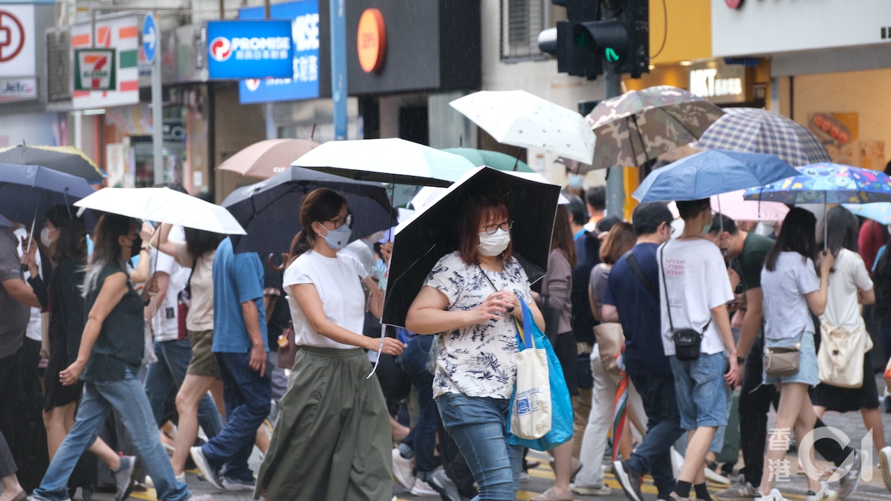
The Observatory issued an alert signal No. 1 at 3:40 am today (9th).
According to the current forecast path, the tropical depression will maintain a distance of more than 500 kilometers from Hong Kong this morning, and the No. 1 alert signal will be maintained until 10 am this morning.
Later, depending on the wind changes in Hong Kong, consideration will be given to the issuance of the No. 3 Strong Wind Signal.
Hong Kong will be affected by the outer rainbands of the tropical depression today, with squally showers and thunderstorms, with heavy rain at times.
There will be large waves and swells on the sea surface, the public should stay away from the shore and stop all water activities.
Typhoon Signal No. 1|Earlier than the Macao Meteorological Bureau of the Hong Kong Observatory issued a forecast path map tonight
In the early morning of August 9, a thunderstorm area was crossing Hong Kong from east to west.
▼The Observatory issued a yellow rainstorm warning on August 3▼
+3
The Observatory issued a special weather warning in the early morning: a wide area may be affected by heavy rain
A thunderstorm area is traversing Hong Kong from east to west.
The Observatory issued a special weather alert at 0:00 a.m., indicating that a wide area of Hong Kong may be affected by heavy rain in the short term, and strong gusts of up to 70 kilometers per hour or more are expected to continue to hit Hong Kong. At 0:15, Tap Mun recorded over 70 per hour The strong gust of 1000 kilometers reminds citizens to take shelter in a safe place as soon as possible if they are outdoors.
A thunderstorm warning was issued at 5:40 p.m. yesterday (8th) and is valid until 3:30 a.m. today. Several squally thunderstorms are expected in Hong Kong.
High chance of re-issue of Typhoon Signal No. 3 in Macau today
The Macao Meteorological Bureau issued the No. 1 typhoon at 7 o'clock last night and will maintain it in the early morning.
The Bureau of Meteorology said that at 11:00 last night, the tropical depression was about 740 kilometers south-southwest of Macau, and it generally trended towards the east and west coasts of Guangdong. The chance of a typhoon is high, and the chance of turning No. 8 at night is medium.
Affected by the circulation and rainbands of the tropical depression, the Meteorological Bureau expects the weather to become unstable, with stronger winds from today to tomorrow (10th), with more frequent showers and thunderstorms; as the next few days will be astronomical spring tides , under the influence of superimposed storm surge and continuous rainfall, flooding will occur in low-lying areas from early morning to early morning from tomorrow to Thursday (11th).
The Macao Meteorological Bureau predicts that the chance of typhoon No. 3 being issued today is high.
Mainland Central Meteorological Observatory predicts that it will intensify to tropical storm level
The Central Meteorological Observatory of the Mainland issued a typhoon bulletin at 6:00 p.m. yesterday. A tropical depression in the South China Sea was formed in the afternoon. At 5:00 p.m., its center was located in the central and western part of the South China Sea, about 170 kilometers west of Sansha City (Xisha Yongxing Island), Hainan Province, near the center. The maximum wind force is level 7 (16 m/s), and the central minimum pressure is 1000 hPa.
The Central Meteorological Observatory predicts that the tropical depression will first rotate and move less in the central and western waters of the South China Sea, with little change in intensity. It will begin to move northerly today, and its intensity will gradually intensify. It may intensify today to become the No. 7 typhoon this year, with a maximum intensity of up to the tropical cyclone. The storm level will make landfall on the coast from northeastern Hainan Island to western Guangdong from tomorrow afternoon to evening.
The Meteorological Observatory said that from 8:00 last night to 8:00 tonight, there will be winds of magnitude 6 to 7 in most waters of the South China Sea, west of the Bashi Strait, south of the Taiwan Strait, and the coast of Guangdong, with winds of magnitude 8 near the low pressure center. , Gust level 9.
▼The situation under the tropical depression No. 1 typhoon on August 4▼
+4
Today's offshore and highland winds reach No. 3, and the typhoon will intensify to Category 8 gale force tomorrow
The Observatory updated the nine-day weather forecast at 0:00 a.m., which is roughly similar to the forecast at 4:30 p.m. yesterday. It means that due to the influence of its outer rainbands, there will be squally heavy showers and thunderstorms in the northern part of the South China Sea and the coast of Guangdong in the next one or two days. There are swells.
However, the Observatory said that due to the influence of its outer rainbands, there will be squally, heavy showers and thunderstorms in the northern part of the South China Sea and the coast of Guangdong in the next two or three days. The wind will be quite strong and there will be swells in the sea. The shore blows at level 6 (strong wind), and later it reaches level 7 (strong wind) in the highlands.
That is, the wind force of the No. 3 typhoon (level 6 and 7) will also reach level 6 early tomorrow, and the offshore and highland will reach level 8 (strong wind), which is the wind force of the No. 8 typhoon.
The Observatory predicts that it will be cloudy with showers on Thursday and Friday (11th and 12th), and there will be squally thunderstorms on Thursday. At first, the rain is sometimes heavy, and there will be swells in the sea.
This Saturday (13th) and next Sunday (14th) will be sunny for a short time, with a few showers.
However, a broad trough of low pressure is expected to affect the northern part of the South China Sea from late this week to early next week, where there are still showers.
▼A rainbow appeared in multiple districts on the morning of August 6▼
+10
The wind is blowing | The Observatory will hang the No. 1 typhoon signal as soon as tomorrow morning, the thunderstorm will continue to hit Hong Kong and the rain will continue until next week. Weather Traffic | Today is cloudy and there will be squally thunderstorms up to about 31 degrees. There will be showers and winds in the next few days. The typhoon signal No. 1 will cross the northern part of the South China Sea on Tuesday and Wednesday. The Observatory expects that the South China Sea low pressure area will be upgraded to a tropical cyclone tomorrow or consider the typhoon signal No. 1. The Observatory expects multiple factors to be favorable for the low-pressure area to rise. Tropical cyclone 8.9 will cross The Feng Hengyu Observatory issued a special reminder that the thunderstorm area will affect Hong Kong's afternoon squally thunderstorms in the next one or two hours