
Classic summer photos in Death Valley, on the border between the states of California and Nevada (United States), show scantily clad tourists next to a thermometer with temperatures of more than 50 degrees or with a frying pan on the asphalt in which an egg is fried.
It is common in weather information, but always for breaking high temperature records.
It is considered the driest place in the United States.
However, in this summer of extreme events, visitors who had dared to brave the heat have been surprised by torrential rains, a once-in-1,000-year event.
The accesses to the park have had to be closed due to the flooding and the damage caused to the roads by the storm.
This year, the region had been suffering from an intense drought.
About 100 kilometers away, in Lake Mead, outside Las Vegas, the water level has dropped so low that bodies that had been submerged for years or even decades have begun to appear.
One of them, decomposed inside a corroded metal barrel, immediately fueled theories about mob murders.
From drought to floods.
"Death Valley is an incredible place of extremes," Park Superintendent Mike Reynolds said in a statement released by the National Park Service.
“It is the hottest place in the world and the driest in North America.
This week's 1,000-year flood is another example of this extreme environment.
With climate change models predicting more frequent and intense storms, this is a place where you can see climate change in action,” he added.
The one who defined the floods in these terms was Daniel Berc, a meteorologist at the National Weather Service in Las Vegas, who specified in a statement: “A 1,000-year event does not mean that it occurs once every 1,000 years, but rather that there is a 0.1 % chance of occurrence in a given year.
About 60 vehicles of visitors and employees were trapped by the mud and the remains moved by the water.- (AFP)
In just three hours of storm, some 37 liters per square meter fell, the equivalent of 75% of the volume of annual rainfall.
In any place accustomed to receiving rain, it probably would not have caused the destruction and landslides that have occurred in Death Valley, which remained with all the roads closed last weekend and is gradually recovering normality.
However, most of the roads in the park remain closed due to flooding and damage.
As is often the case with floods, the rain has left the park without drinking water.
Hundreds of meters of the main pipeline that supplies the park were uprooted, leaving some homes, the emergency operations building and other facilities unsupplied.
There were no injuries among visitors or residents of the park.
Many tourists saw their cars trapped by the mud, but were able to remove them and leave the park despite the damage to the roads.
High temperatures
Temperatures in Death Valley National Park in the summer can reach 120 degrees Fahrenheit in the shade (much higher in photos with thermometers in the sun taken by tourists).
The highest air temperature in history, 57 degrees, was recorded in Furnace Creek on July 10, 1913. The second highest temperature ever recorded in the park, 54 degrees, occurred on August 16, 2020.
The valley is situated 86 meters below sea level.
One would expect the water to pool and form a lake, given that altitude.
But as NASA explains, what there is is a desert subject to a "rain shadow" effect.
Moist air masses traveling east from the Pacific Ocean must cross four mountain ranges before reaching the valley.
As air masses rise to clear the mountains, the moisture they carry condenses and falls as rain on the western slopes, leaving a dry area, or rain shadow, on the eastern side.
By the time most air masses reach Death Valley, they are completely dry.
Death Valley has the lowest point in all of North America, but it's only about 90 miles east of 4-acre Mount Whitney.
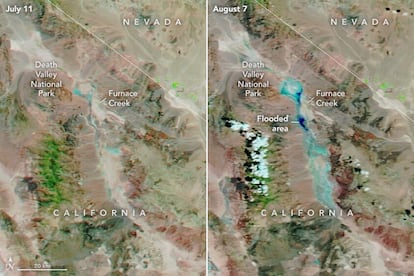
Satellite images released by NASA showing flooding in Death Valley (California).
On rare occasions, the lower part of the valley is filled with a wide, shallow lake, nicknamed Badwater Lake, but extreme heat and dryness often cause that short-lived lake to quickly evaporate, turning the valley floor into a beach of salt, another focus of the visitors' photographs.
NASA has released some satellite images showing how exceptional the water accumulated after the floods.
Despite its extreme conditions, it is the land of the Timbisha Shoshone Native American tribe, who have inhabited the valley for at least the last millennium.
It owes its name to some explorers who got lost in it in the middle of the 19th century and believed that they would not survive.
One of them died.
The rest were rescued.
One of them, walking away, turned around and said: "Goodbye, valley of death."
You can follow CLIMA Y MEDIO AMBIENTE on
and
, or sign up here to receive
our weekly newsletter