
The heat wave continues to spread in the West and in the Paris basin with the maintenance of an anticyclone on the British Isles, according to
La Chaîne Météo*
.
A light wind will rise on the Aquitaine coast which will refresh the coastline.
In the Mediterranean, good weather dominates with little instability in the mountains.
Rare heat storms can be expected in the afternoon in the mountains, particularly in the Pyrenees.
Read alsoFires: Europe is mobilizing to help France
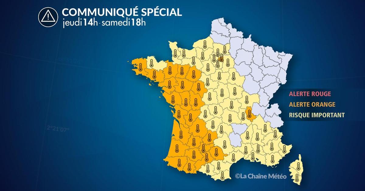
Charente, Charente-Maritime, Dordogne, Finistère, Haute-Garonne, Gers, Gironde, Ille-et-Vilaine, Landes, Loire-Atlantique, Lot, Lot-et-Garonne , Maine-et-Loire, Mayenne, Morbihan, Pyrénées-Atlantiques, Hautes-Pyrénées, Rhône, Sarthe, Paris, Deux-Sèvres, Tarn, Tarn-et-Garonne, Vendée, Vienne, Hauts-de-Seine, Seine-Saint-Denis and Val-de-Marne are placed on
heat wave
orange alert .
The weather in your area
In the
North-West
and in
Normandy
, the day will be very hot.
From the morning, the temperatures will be between 16 and 18°C on the English Channel and already 20°C elsewhere.
A light breeze on the coast will attenuate the heat wave in the afternoon while Normandy will reach 33°C.
In the
Centre-Val de Loire
and
Ile-de-France
, the morning will be warm and the afternoon scorching.
We will reach 33 and 35°C, or even slightly more.
No clouds will be in sight.
The
Hauts-de-France
will also see a very hot and sunny day.
Everywhere temperatures will exceed 30°C and no coastal breeze will cool the air.
Read also Heat wave: everything you need to know about the new heat wave expected in France from this Monday, until August 15
In the
South-West
, the heat wave will be particularly intense with temperatures reaching 40 and 41°C, especially in the Garonne valley.
On the coast, a light wind will lower the 30°C bar and bring humidity to the forests of Gironde and Landes.
In the
Pyrenees
, heat storms will break out at the bottom of the valleys and in Andorra.
From
Burgundy-Franche-Comté
to the
Grand Est
, the day will be very sunny after a relatively airy night.
The minimum temperatures will be between 15 and 20°C, while the maximum will reach 30 to 34°C.
From
Auvergne-Rhône-Alpes
to
Corsica
via the
PACA
region , the sun dominates despite the slight instability in the Mercantour and the Corsican mountains.
A few sea mists will ease the conditions a little on the coast while the heat will be marked in the Rhône Valley.
The minimums will be between 17°C in the Center-East and 26°C in Nice.
The principles will go from 29°C to 37°C.
In
Occitania
, the intense heat continues with only a few sea breezes in the Gulf of Lion which will slightly limit the temperatures in the afternoon.
Minimum temperatures will show between 20 and 30°C.
The maximums will show 28 to 39°C.
*The Weather Channel is a property of the Figaro group.


