A mega flood is coming in California, study reports 3:54
(CNN) --
A tropical storm watch has been issued from Port Mansfield, Texas to Boca de Catan, Mexico, according to the National Hurricane Center.
The watches are associated with a system that the National Hurricane Center has designated as Potential Tropical Cyclone Four, located in the southern Gulf of Mexico, about 643 kilometers (400 miles) south-southeast of the mouth of the Rio Grande.
The hurricane center uses the potential tropical cyclone designation to issue warnings for a system before it is named.
"As the system is likely to further develop and make landfall as a tropical storm in less than 36 hours, advisories on potential tropical cyclone four are being initiated with tropical storm warnings issued for portions of the northeastern coasts of Mexico and south Texas," the Hurricane Center said in its forecast discussion.
Regardless of development, the system is expected to bring heavy rain to northeastern Mexico and far southern Texas.
Rainfall amounts of up to 8 inches (20 centimeters) are possible in Mexico, and 1 to 3 inches (2 to 7 centimeters) are expected in far southern Texas.
The next extreme floods could be even worse, according to a new study.
But there's a way around it
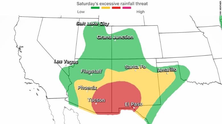
Meanwhile, the rest of the desert Southwest, an area facing a long-term megadrought, is bracing for a moderate risk, Level 3 of 4, of extreme rainfall, which could lead to flash flooding on Friday and Saturday.
advertising
"A multi-day significant rain event is forecast in the southwestern US this weekend," the Weather Prediction Center said.
"Shocking showers are very likely in portions of southeastern Arizona to southwestern New Mexico, with total storm amounts between 5 and 6 inches (12 and 15 centimeters).
Flood advisories are posted for nearly 10 million people across the Southwest, including Tucson, Phoenix, Albuquerque and El Paso, through Saturday.
Zack Taylor, senior meteorologist at the Climate Prediction Center, noted that there are multiple factors creating the new surge of moisture, including remnants of a tropical wave currently over northern Mexico embedded in the large-scale monsoon.
Where rain is expected this week
One thing that makes this particular event different is the timing of the storms.
Monsoon storms typically occur during the day, in the afternoon, and in the evening.
But this time, the possibility of rain will be all day.
The storms will rage in the afternoon and early evening as usual, but will also occur Friday night and early Saturday morning.
There are also two timelines as to the impact with the next system.
In the short term, it would be flash flooding, and in the long term, it would be the effects on rivers, streams, and creeks in the area.
"Initially, the main concern is flash flooding," Jeff Davis, chief meteorologist at the National Weather Service office in Tucson, told CNN.
By the end of the weekend, the rain will extend as far east as Texas, another state experiencing significant drought.
Early next week, 3 to 5 inches (7 to 13 centimeters) of rain is possible from Lubbock, Texas, to Shreveport, Louisiana, increasing the potential for flash flooding in those areas.
Monsoon rains are helping the drought, but not enough
A mega flood is coming in California, study reports 3:54
While the desert southwest may not be known as a wet part of the country, this time of year is when rain is most likely.
The rainy season helps the Southwest, but often leads to a superficial improvement.
The drought-stricken region is already dealing with a water crisis, so they need the rain, but it may not be as beneficial as it seems.
Drought and extreme heat are hitting the world's three largest economies at the same time
One concern with the heavy rains coming is that it is not expected to rise far enough to the north or west, where the water is most needed: California, Nevada, Oregon and northern Utah.
"Several major areas of improvement were seen this week, with the heaviest rains and the most widespread improvement covering Arizona," details the latest US Drought Monitor. "After a prolonged period of severe drought, heavy rains have brought about a large-scale improvement in monsoon-affected areas.
Recent rains have helped, but only for some areas in the west.
About 70% of the West is still in some level of drought, up from 90% just three months ago.
Most of the improvements have been made in just two states, Arizona and New Mexico.
Recent rains have further helped those two states.
Tracking the drought in the United States
USA: the Colorado River dries up and this is the Government's plan 3:46
"Monsoon rains are only a fraction of the West's water needs," said Chad Myers, a CNN meteorologist.
"That said, recent rains have raised the level of Lake Mead by 54 centimeters (1.8 feet) in the last three weeks."
Myers noted that the main driver of water in this region is melting winter snowpack, but that doesn't mean rain isn't beneficial.
"Although the heaviest rains ahead will not reach the Colorado River basin or Lake Mead, much will still fall in Utah and Colorado directly into the upper drainage basin of the river," Myers said.
The US Southwest monsoon officially runs from June 15 to September 30, putting the region past the middle of the season.
The National Park Service claims it found a third set of human remains in Lake Mead amid drought
Recent rain in Las Vegas has raised the monsoon total to 39 centimeters (1.29 inches), marking the wettest monsoon season in a decade.
However, the city is still well below what it should be at this time of year, having received just over half of its average rainfall through mid-August.
The 1.29 inches (39 centimeters) this season already makes 2022 the third-wettest Las Vegas monsoon of the 21st century.
It comes just two years after the driest monsoon on record in the summer of 2020, when there was no measurable rain.
Up ahead in Tucson, they have recently had a rollercoaster ride of monsoon seasons.
2020 was the second driest on record at 49 centimeters (1.62 in), while 2021 managed to be the third wettest at 389 centimeters (12.79 in).
So far this season, just over 60 centimeters.
(2 inches) have fallen in the city, below the average to date of 106 centimeters (3.48 inches).
Salt Lake City has had 6.70 inches (204 centimeters) so far this year, but its average is more than 10 inches (304 centimeters).
It is an ever present sign of how severe the drought has been in the last few decades in the region that we are receiving a little more than half of normal.
CNN Meteorologists Pedram Javaheri and Tom Sater contributed to this story.
RainsDrought