
The day after the hottest day of the week, temperatures are finally dropping in the West, according to
La Chaîne Météo
*.
In the East, the heat is maintained and is accompanied by sometimes dangerous stormy degradations in the Center.
After the storms pass, temperatures drop near the Atlantic coast.
Read alsoFaced with heat waves, are thunderstorms inevitable?
The weather in your area
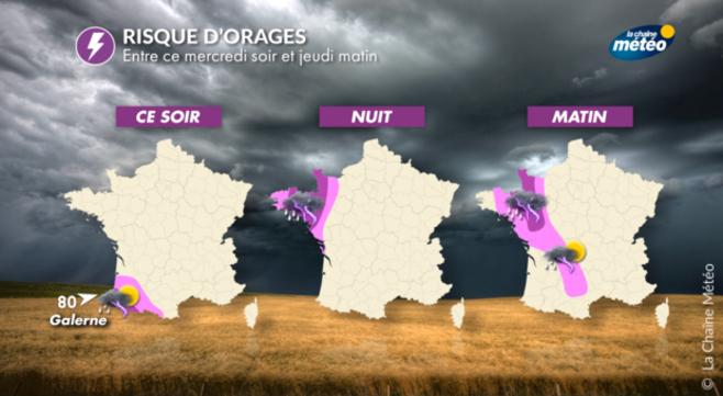
From
Brittany
to
Normandy
via
Pays de la Loire
, heavy stormy rain fell in Loire-Atlantique, Ille-et-Vilaine and Lower Normandy.
In the afternoon, the sun returns to the tip of Brittany.
The minimum temperatures are between 16 to 21°C and the maximum drops with 20 to 24°C.
In
Centre-Val de Loire
,
Hauts-de-France
and
Ile-de-France
, the morning will be dry after a generally tropical night in the big cities.
The clouds grow in the afternoon with a risk of rain north of the Seine.
The minimums are between 17 and 22°C and the maximums between 23 and 31°C.
From the
Grand-Est
to
Corsica
, but also from
Bourgogne-Franche-Comté
to
Auvergne-Rhône-Alpes
, the weather conditions remain very hot.
At the end of the day, thunderstorms are developing in the Massif Central and are likely to be violent.
The minimum temperatures are 15 to 22°C and the maximum 29 to 34°C.
In
Occitania
and
New Aquitaine
, the sky will be very overcast except in the Pyrenees.
In the afternoon, the sun breaks through the clouds before a strong return of thunderstorms in relief.
The tramontane will blow in Roussillon.
The minimum temperatures are between 19 to 22°C and the maximum between 25 to 34°C.
*The Weather Channel is a property of the Figaro group.