
This hurricane season is being very anomalous and right now a more anomaly is brewing relatively close to the Canary Islands, at which time it may affect during the weekend, warns the State Meteorological Agency (Aemet).
It is, explains its spokesman, Rubén del Campo, a tropical wave that is moving from the interior of the African continent towards its western coast and that has a 50% chance, letter or cross, of becoming a cyclone - a term that includes tropical depressions, tropical storms and hurricanes depending on the strength of their winds—.
If it finally does, it may affect the Canary Islands over the weekend in the form of heavy rains and winds, but it is still too early to have an accurate forecast.
The National Hurricane Center (NHC), which is the body in charge of monitoring the formation, forecast and impact of tropical cyclones in the Atlantic, is monitoring said wave, which "will move in the coming days over ocean waters heading north.
On its way, "it will find favorable conditions for its intensification", so this Wednesday "the chances of it becoming a cyclone within the next five days are estimated at 50%," Del Campo details.
At the moment, the phenomenon does not have a name, since the NHC will baptize it only in the event that it evolves into a cyclone.
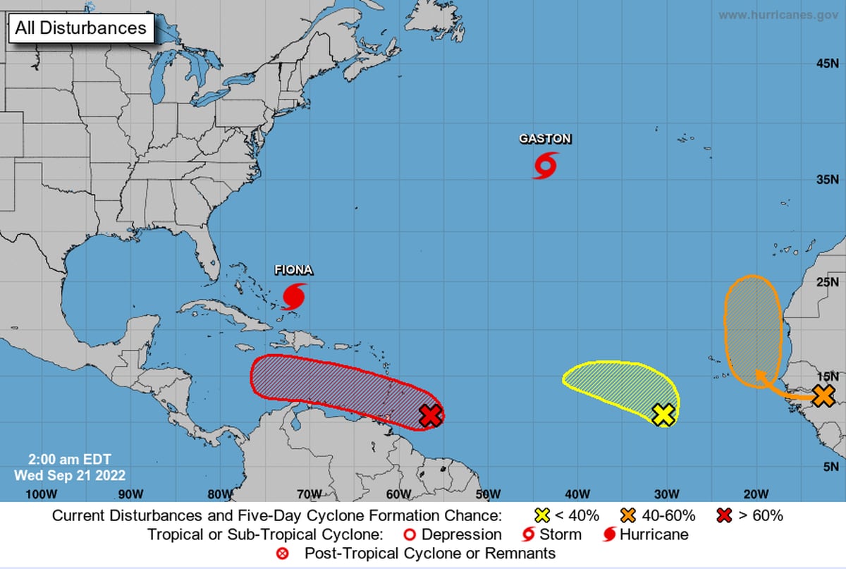
After a summer with very little cyclonic activity, the Atlantic has "awakened" in September.
There is quite a bit of activity right now, with a tropical storm, a hurricane, and three developing systems.
Of these three, we are especially interested in one.
Follow...
👇 pic.twitter.com/D8CiLXsCyg
– AEMET (@AEMET_Esp) September 21, 2022
So far this season, the tropical storms
Alex
,
Bonnie
and
Colin
have been named , the famous hurricane
Danielle,
which reached Spain downgraded to a storm,
and the also hurricanes
Earl,
Fiona
and
Gaston.
Currently, the NHC monitors three disturbances, of which the one in the Canary Islands is the two and the second one that has the most possibilities of ending up being a cyclone, after another generated in the south of the Antilles, whose probability is 90%.
If either of them became a cyclone, and it is possible according to Del Campo that the one in the Antilles forms before, it would be
Hermine
.
The next, which may be the Canary Islands, will be named after
Ian.
This is yet another rarity of a season in which we had to wait until August for the appearance of the first hurricane.
"That there are no hurricanes in June or July is the first time that has happened in 25 years," notes the meteorologist.
But apart from the scientific interest that it is developing so far from its natural basin, the big question is what consequences it will have.
Today's simulations of the models increase the potential for tropical cyclone formation and approach to the #Canaries.
Only 4 days ahead, the models begin to converge.
But do not forget that predictability is still low, and there may be changes.
pic.twitter.com/NuSRbZshbM
– JJ González Alemán (@glezjuanje) September 21, 2022
"The prediction of this type of tropical system and its trajectory is subject to many uncertainties and, although it is expected to move north parallel to the African coast, it is not yet possible to determine to what degree it will affect the Canary Islands," acknowledges Del Field, which explains that we have to wait for the NHC to offer its most probable trajectory cone.
However, the latest forecasts suggest that “the cloud bands associated with the possible tropical cyclone will leave rains” starting on Saturday on the islands, especially in the western ones and in Gran Canaria, which can be intense.
And it is also possible that it could lead to very strong gusts of wind on the summits.
Aemet monitors the situation and "as it becomes more predictable" in the coming days, it will report on the evolution of the wave.


/cloudfront-eu-central-1.images.arcpublishing.com/prisa/EDZCE4O5FQYSLPIQ3ZOP6LWRCM.jpg)

/cloudfront-eu-central-1.images.arcpublishing.com/prisa/S7EEXKSOAFNC5GML424T7A7DFY.jpg)
