
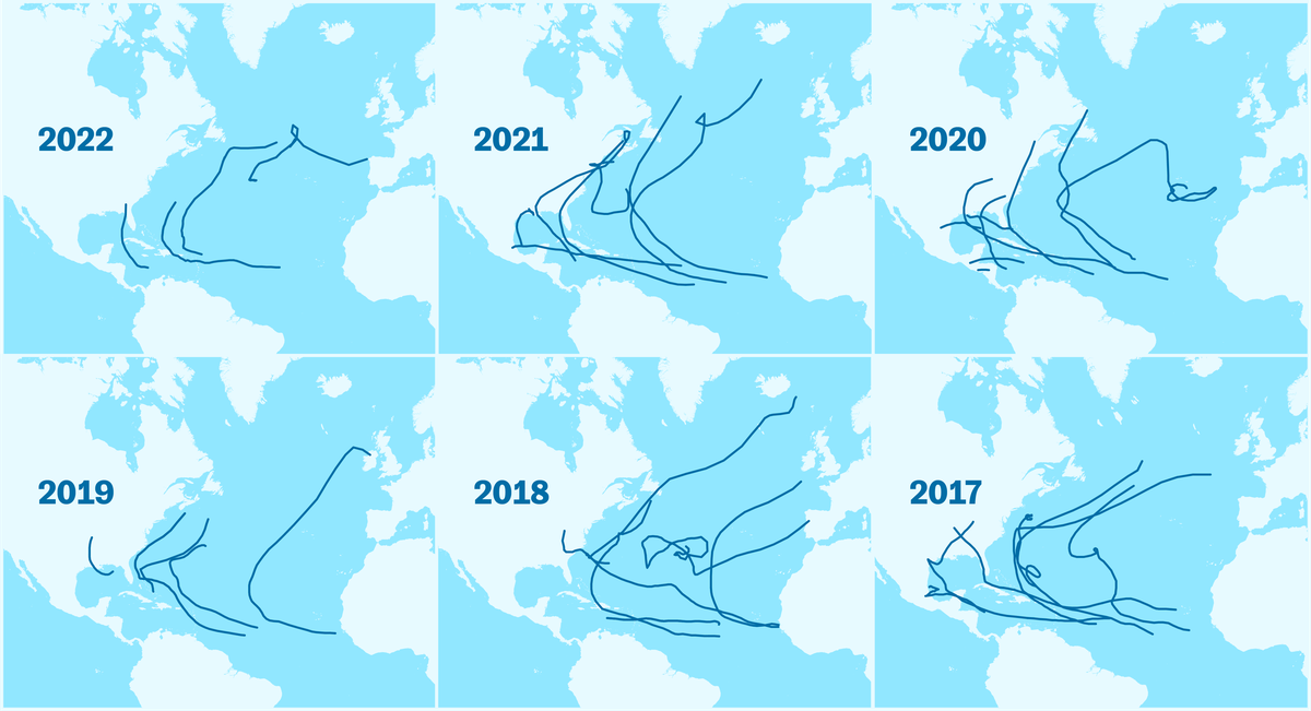
All summer long, meteorologists have asked themselves a disturbing question: where are the hurricanes?
The authority on the matter, the US National Hurricane Center (NHC), had forecast a more intense than normal season of tropical cyclones in the Atlantic, a term that encompasses tropical depressions, tropical storms and hurricanes, based on the strength of its winds.
However, until this month, she was being unusually calm.
In fact, for the first time in 25 years, there was no sign of the dreaded hurricanes in June, July and August.
But in September, the Atlantic has woken up: there are already nine cyclones – four of them hurricanes – and two of them,
Danielle
and
Hermine
,
they constitute a rarity because of the place where they arise and because of their trajectory.
Added to these is
Fiona,
the strongest cyclone to reach Canada.
The last to arrive is
Ian
, who has made landfall in Cuba and is headed for Florida.
"The season is being abnormal," says Juan Jesús González Alemán, the leading Spanish expert in tropical systems and a researcher in atmospheric dynamics at the State Meteorological Agency (Aemet).
More information
Hurricanes 'learn' the way to Spain
In May, the NHC released its forecast for this season – which runs from June 1 to November 30 –: a 65% chance that it would be more intense than normal compared to a 10% chance that it would be weaker.
However, the reality during the first months has been different.
Even before the start, this year no tropical storms were named before the cyclone period began in June, which had not happened since 2014. Still, in August, with only three storms ―
Alex
,
Bonnie
and
Collin
― , the agency maintained its forecasts, but lowered the percentage to 60%.
“In principle, several oceanic and atmospheric indicators invited us to think that it would be a powerful season”, contextualizes the spokesman for Aemet, Rubén del Campo.
On the one hand, La Niña, which continues for the third consecutive year and favors the formation and intensification of these phenomena, by reducing wind shear conditions, that is, its variations in intensity and direction as it rises in the troposphere.
By having a clear path, cyclones can develop their symmetrical structure and intensify.
The other favorable condition was a forecast of warmer than normal waters, the fuel on which these meteorological monsters feed.
A third factor was that the African monsoon was expected to be more active,
However, the summer ended without hurricanes, something that had not happened since 1997. That year was a very intense El Niño, which promotes very hostile conditions for hurricanes because it generates shear.
What happened this time?
"There were special circumstances for the activity to drop," summarizes González Alemán.
Del Campo specifically points to “two unforeseen factors”.
On the one hand, a trough —an area of low pressure in the upper layers with cold air in its heart— has persisted in the tropics with very intense westerly winds at high levels while blowing almost in the opposite direction at lower levels, which multiplied the shear.
In addition, this air, from the Sahara to the Atlantic, was very dry and dusty, so it did not contain enough moisture to condense and release the energy required by these systems.
After spending the summer sleeping, the season has taken a turn in September and its activity is already average, with nine named cyclones, the last two,
Hermine
and
Ian
, on the weekend.
“There has been a
switch
effect , which is not uncommon.
It has happened in six seasons since 1961, without hurricanes in August and from 9 to 10 in September”, explains Del Campo.
"From one month to another, conditions have changed and September has been completely different," adds González Alemán.
As the season has sprinted, it is possible that the forecasts are fulfilled and the hyperactivity that has marked the last six seasons will continue.
In addition to getting out of torpor, September has surprised with two cyclones outside its natural highway.
One was
Danielle,
the first hurricane of 2022. "More than its trajectory towards Europe, the strange thing is where it originated," Del Campo points out.
He did it 1,000 kilometers west of the Azores, "almost at the latitude of Andalusia", when his quarries are in the surroundings of Cape Verde or the Gulf of Mexico.
Already converted into an extropical cyclone, it caused a storm in the Peninsula.
“When they form so far north, mid-latitude systems participate that help them intensify, but in this case they were purely tropical mechanisms,” adds this meteorologist.
And he did not need help because the waters were extremely warm, between 3 ° C and 4 ° C above normal, a temperature typical of the Caribbean.
The rains caused by #Hermine have made September 2022 the rainiest in most stations of the main network of @AEMET_Canarias.
In some cases, the rain during the episode is equivalent to about 80% of the average annual precipitation
👇 pic.twitter.com/SrXJBfgqdS
– AEMET (@AEMET_Esp) September 27, 2022
The second derailed was
Hermine.
Unlike
Danielle
, what is anomalous is not where she was born, but "her displacement to the north" instead of to the Caribbean.
For González Alemán, "the approach of a tropical storm to the Canary Islands is an extremely anomalous event", but it must be analyzed in depth before making further considerations.
According to the researcher, it is very possible that it is the cyclone that has come closest to the archipelago with robust data since 1966, although he acknowledges that they could go unnoticed before.
“There are records and testimonies that go back further, but you have to track them down.”
In the absence of attribution studies that establish what percentage can be attributed to man, this expert sees
Danielle
's connection with climate change more clearly than with
Hermine.
With the first there was an intense wave of marine heat in the North Atlantic, a phenomenon in which there is a good attribution and that favored "the intensity that it reached in that area".
On the other hand, in
Hermine
"a relationship that many people venture is not clear, it is necessary to carry out an in-depth analysis, calculate the anomaly and put it in a historical context, because there is an anomaly with respect to the last 50 years, but we do not know if the there is with respect to the pre-industrial period”.
What worries him is that
Hermine,
“placed in the context of climate projections, it suggests that it is a preview of what may come, category 2 and 3 hurricanes”, since there are studies that point to greater cyclone
seeds
: more tropical waves, more intense and more to the north.
This new “Atlantic warning” has been serious, causing a “notable impact”, with “historic and extraordinary” rains.
The Atlantic is still very active ⚠️🌀
Hurricane #Ian reaches category 2, with sustained winds ≥ 160 km/h.
In the next few days, predictably, it will move north becoming a major hurricane (cat. 4) and hitting the coast of #Florida with great force.
pic.twitter.com/1B6Ffct4KU
– Andrés Gómez (@agomezmeteo_tve) September 27, 2022
“It is a strange event that opens the door to wondering what is happening, since in the last seven years the frequency with which cyclones prowl us has increased, but blaming climate change is taking too much risk,” he reiterates.
"Attributing the behavior of a cyclone or a season to climate change is a mistake, changes must be observed over several decades and in-depth studies must be carried out," the researcher stresses.
For his part, Del Campo points out that this is just one of the hypotheses cited by the CNH to explain the increase registered in recent decades in the Atlantic, together with improvements in observation and natural variations in climate.
For this expert, it is "a piece of cake that if the Atlantic is warmer, hurricanes have more fuel",
When the focus is extended to the Pacific and Indian Oceans, the role of climate change is also unclear because neither an upward nor a downward trend is observed, nor is there an increase in the intensity of the wind.
However, "their rains have grown considerably as a result of climate change and they also" move more slowly, "so they cause more damage.
For González Alemán, there is “a lot of confusion and a lot of noise regarding cyclone activity and climate change” and it is easy to blame the usual suspect.
Their number "does not have to increase with climate change, what is known is that the proportion of category 3, 4 and 5 [the most serious] will be higher," he concludes.
Subscribe here
to our daily newsletter about Madrid.
Subscribe to continue reading
read without limits
Keep reading
I'm already a subscriber


/cloudfront-eu-central-1.images.arcpublishing.com/prisa/JFA2SLZ7WFEXLKEZWS2UNF3F6U.jpg)