Ian: They forecast for Tampa "almost the worst case scenario" 0:45
(CNN) --
Hurricane Ian is rapidly strengthening as it passes over the ultrawarm waters of the Caribbean and the Gulf of Mexico.
The National Hurricane Center had forecast that the system would rapidly intensify from a tropical storm to at least a Category 4 hurricane in less than 72 hours.
It's an unprecedented forecast, experts told CNN, but scientists say it's becoming more likely as the climate crisis progresses, raising ocean temperatures and setting the stage for tropical storms to explode at breakneck rates and become major deadly hurricanes.
🌀 Follow Ian's journey live
Rapid intensification is just what it sounds like: a hurricane's winds strengthen rapidly in a short period of time.
Scientists have defined it as an increase in wind speed of at least 56 kilometers per hour in 24 hours or less.
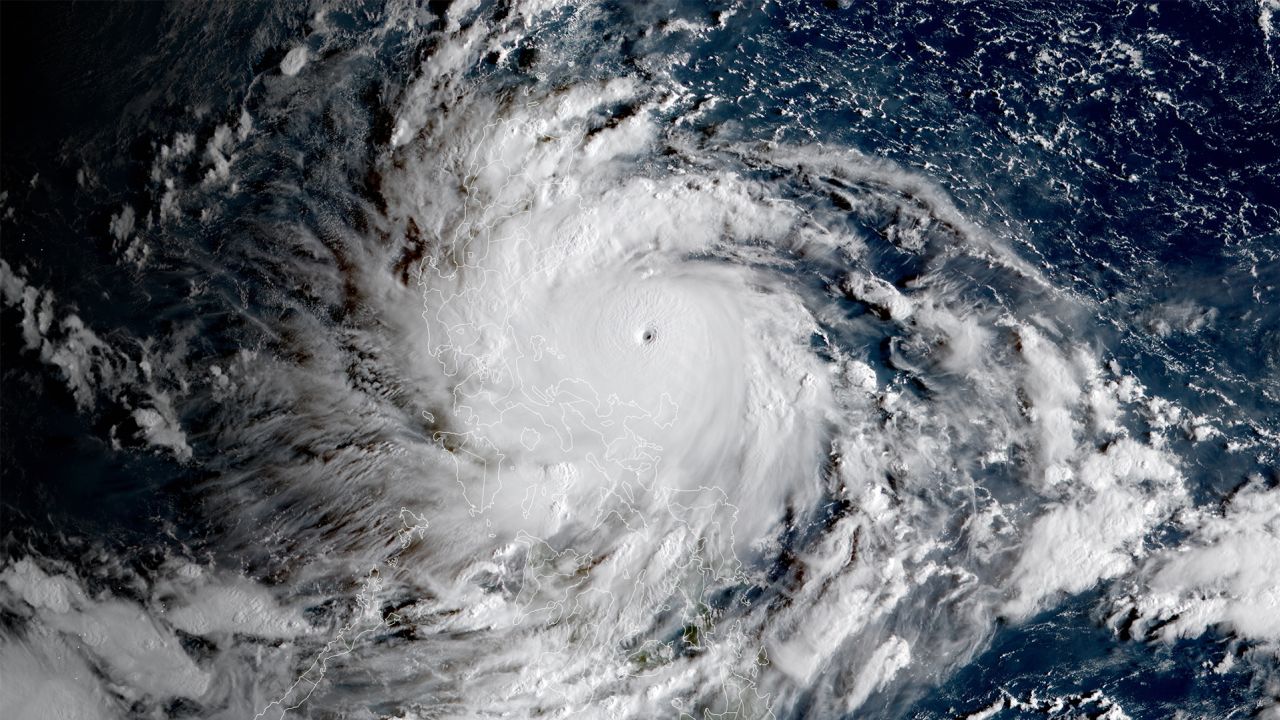
The phenomenon unfolded at breakneck speed in the Philippines this weekend.
Super Typhoon Noru blew up with force on its final approach to the Pacific island nation, going from the equivalent of a Category 1 hurricane to a Category 5 one overnight as Manila residents slept.
Super Typhoon Noru blew up in intensity overnight, before making landfall in the Philippines on Sunday.
Noru's rapid intensification just before landfall, which was not predicted, likely meant locals didn't have time to prepare for a much stronger storm.
advertising
Hurricane Ian has been in the forecast for days, giving Cuba and Florida the benefit of the weather.
Winds in the storm increased from 45 mph on Sunday night to 80 mph on Monday morning, with further strengthening forecast.
Ian could intensify to at least a Category 4 hurricane before making landfall in Florida by midweek.
Historically, rapid intensification has been a rare phenomenon, according to Allison Wing, an assistant professor of atmospheric sciences at Florida State University.
"It's really at the extreme end of how quickly storms can intensify," Wing told CNN.
“Only about 6% of all forecast time periods have those kinds of observed rapid intensification rates associated with them.
And so it's something that is by definition a rare event.
Sometimes it only happens a few times a season.”
But man-made climate change is favoring more intense storms.
So not only are they generating more rain and larger storm surges, but they are also more likely to be stronger and intensify faster.
What hurricanes are there and what do the categories mean?
"Climate change is increasing both the maximum intensity these storms can reach and the rate of intensification that can bring them to this maximum," said Jim Kossin, senior scientist with the Climate Service.
"The intensification rates at Noru and Ian are good examples of very rapid intensification, and there have been many others recently."
Two ingredients must come together for rapid intensification to occur, Kossin told CNN.
The first is that the upper-level winds around the hurricane must be weak: strong winds can prevent a storm from intensifying or even tearing it apart.
The second is that warm ocean water must extend far below the surface, hundreds of feet deep, to provide enough fuel for the hurricane to strengthen.
More than 90% of global warming in the last 50 years has taken place in the oceans, according to the National Oceanic and Atmospheric Administration.
The last five years have been the warmest on record for the world's oceans.
Scientists have shown that humans are the main cause of the relentless warming trend.
Fossil fuel emissions that warm the planet trap heat in the atmosphere, creating an energy imbalance.
The oceans, in turn, absorb 90% of the excess heat, which has caused an alarming rise in temperature.
This is what Ian looks like inside from a hurricane hunter plane 0:38
And much of that warming has occurred in the upper levels of the ocean where hurricanes get their energy, said Jeff Masters, a meteorologist at Yale Climate Connections.
"Hurricanes and typhoons are heat engines, meaning they take heat energy from the oceans and convert it to kinetic energy which is winds," Masters told CNN.
"So if you increase the amount of thermal energy in the ocean by heating it, you're not only going to increase the maximum intensity that they can get, but also the rate at which they reach that maximum intensity."
A 2019 study found that Atlantic hurricanes in particular showed a “very unusual” increase in rapid intensification from the 1980s to the early 2000s, a trend that could only be explained by human-caused climate change. .
And worryingly, scientists found that the most significant changes were happening in the strongest storms, making the most life-threatening hurricanes even more dangerous.
What to do before, during and after a hurricane?
Check out this guide
"Climate change increases the odds that you're going to get a fast intensifier," Masters said.
Some of the most devastating recent hurricanes in the United States rapidly intensified just before landfall, something Hurricane Ian is not expected to do.
More recently, Hurricane Ida in 2021 strengthened from a Category 1 to a strong Category 4 in the 24 hours before making landfall in Louisiana and left a trail of destruction in its wake from the Gulf Coast to the Northeast.
However, forecasters are getting better at seeing the signs of this phenomenon before it happens, giving people along the coast more time to prepare for the worst.
Kossin said there are several reasons for this.
One is that meteorologists are becoming more reliant on computer forecasting models, which are improving seemingly at the speed of light.
The other is that they have seen more extreme cases of rapid intensification in recent years, making it easier to forecast them in the future.
Masters told CNN that it all adds up to better forecasts.
"The forecasts are unprecedented primarily because the [National] Hurricane Center is getting better at their job," Masters said.
Weather models “have improved a lot.
And our forecasting techniques are improving.”
CNN's Brandon Miller contributed to this report.
Climate change