
Full airports for Thanksgiving 1:16
(CNN) --
Whether you're out shopping to take advantage of Black Friday deals, or to exercise after your Thanksgiving party, or to travel home, rain and thunderstorms can cause some delays and headaches.
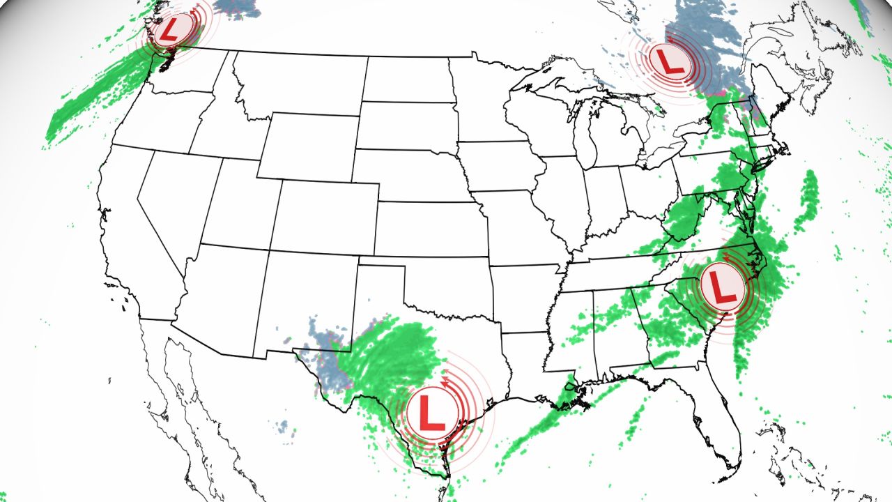
A frontal system this Friday morning brings widespread showers from the northeast to the Gulf Coast.
This is just the first storm system that could cause travel delays in the eastern US this weekend after the Thanksgiving holiday.
What is the origin of Black Friday and why is it celebrated in November?
So if you have plans to head out or travel over the weekend, you may need to pack your raincoat (and your patience).
From Texas to Maine, heavy rain -- and even some snow -- could cause delays on both highways and tracks.
advertising
Travel Issues for the Northeast and Midwest
If you're traveling to or from the Northeast and have flexible travel plans, Saturday and Monday will be the best days to make a move, weather-wise.
"A cold front will arrive [Friday] bringing rain and wind," the New York office of the National Weather Service said in a tweet.
"Keep that in mind if you have outdoor plans or are shopping for Black Friday. High pressures will give us a breather on Saturday before another cold front on Sunday."
Philadelphia, Boston, Baltimore and many other cities will face the same problem this weekend as two separate systems push into the Northeast and Mid-Atlantic.
For Midwestern cities like Chicago, Detroit and Green Bay, Wisconsin, Sunday will be a challenging day with rain and wind.
Cleveland is forecast to have a 100% chance of rain on Sunday, with wind gusts of 30 to 35 mph.
Cincinnati is expected to have similar chances of rain with winds up to 65 km/h.
Prolonged gusts of wind could make flights turbulent and also make it difficult for large vehicles and motorhomes to travel on highways.
This will be the weather for Thanksgiving: showers are expected in the southern US and a storm after Thursday
Two seasons for Texas
On the Gulf Coast of Texas, very heavy rains are possible this Friday, which could cause flooding, including in the greater Houston area.
This has led the Weather Prediction Center to issue a level 3 of 4 of moderate risk due to excess rain.
"Area averages of 50 to 76 mm appear likely with isolated amounts of 76 to 101 mm possible within the moderate risk area," the prediction center said.
Keep in mind that this area has already received 25 to 76 mm in the last 24 hours, so the ground is highly saturated in some places, making it more prone to flooding.
"As a result, this additional rainfall falling in more susceptible locations (including highly urbanized centers) leads to increased risk of flash flooding with some potential for localized/isolated instances of significant flash flooding within moderate risk if formation rounds / repeat are set," the prediction center added.
On the other side of Texas, snow and wind will be the main concerns for travel on Friday and Saturday.
Cold temperatures -- 5.5 to 16.5 degrees Celsius below normal -- combined with abundant moisture are bringing snow showers to parts of New Mexico and West Texas on Friday.
"Initially this will take the form of cold single rain across most of the region with mixed rain and snow expected to start across the southwestern Southern Plains further north along the border. of the state of TX/NM," the weather service office in Lubbock, Texas said Friday morning.
By Friday night, temperatures are expected to cool enough to change to snow in much of West Texas and eastern New Mexico.
The potential exists for totals to reach 101 to 203 mm west of I-27 and through eastern New Mexico.
However, isolated amounts of up to 300mm are possible.
The snow could also reduce visibility on the roads, so please be careful until Saturday morning when you travel.
Multiple storms to the southeast
There are multiple weather systems affecting the Southeast over the next three days, so you may need to be selective about spending time outdoors.
If you live in Atlanta or Charlotte, North Carolina, Saturday will be the driest day as showers and even some thunder are expected both Friday and Sunday due to another storm system.
Little Rock and Memphis will have Saturday filled with downpours and a few thunderstorms.
"Some of these showers and storms could be efficient producers of heavy rain," the Memphis weather service office said, noting that while total accumulation amounts are expected to be around 25mm for most of the Mid-South, "Locally higher amounts will be possible under particularly efficient storms."
While the greatest flood threat is forecast for this Friday along the entire Texas Gulf Coast, there is a level 1 of 4 marginal flood risk Saturday from Houston to Pensacola.
In the southeast, most areas will receive up to 25mm of rain through Sunday night, but some isolated spots could see up to 50mm, especially those under thunderstorms.
Rain and snow return to the Pacific Northwest
And on the West Coast, a frontal system will sweep across the Pacific Northwest on Friday, bringing rain and higher elevation snow to the region on Friday and west of the mountains on Saturday.
In these western ranges there is a winter storm watch and winter weather advisories in advance of expected snowfall.
For communities along the coast and in the valleys, rain will be the main concern, with a total accumulation of 25 to 50mm expected over the next 72 hours.
"Although light snow is expected [this Friday] across the Cascades, a winter storm watch has been issued for Saturday night through Monday morning for the central Cascades as a stronger system brings more snowfall. heavy / high amounts of snow," the weather service office in Seattle tweeted.
"Travel is likely to be difficult over the Steps."
There is >90% chance for at least 6" of snow falling in the Cascades Sunday - Sunday night. There remains some uncertainty when conditions will be at their worst, but the bottom line is that it will be much snowier Sunday than Saturday in the Cascades. #pdxtst #orwx #wawx #MtHood pic.twitter.com/kxbTG7OXML
— NWS Portland (@NWSPortland) November 24, 2022
By Sunday, another frontal system is forecast to bring even heavier rain and mountain snow to the Pacific Northwest on Sunday and the Intermountain West on Monday.
12 to 24 inches of snow is possible in some locations over the weekend.
This snow, combined with wind gusts of up to 65 km/h, could create hazardous travel conditions.
CNN meteorologist Haley Brink contributed to this report.
ThanksgivingStorm