(CNN) --
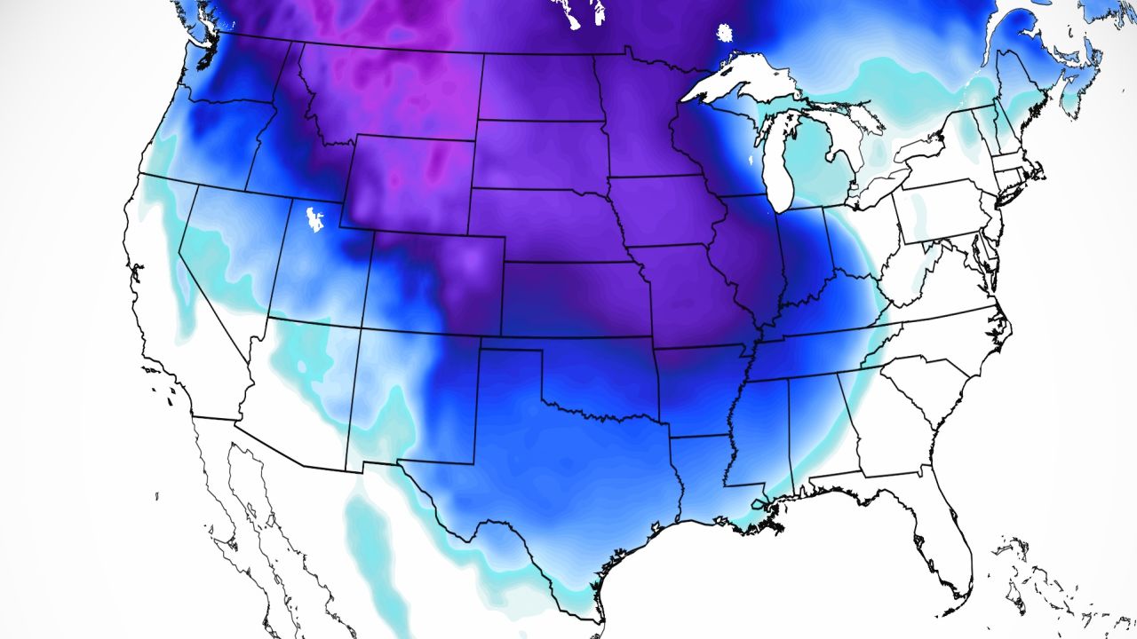
The coldest air of the season, by far, will descend from Canada, bringing dangerously low temperatures to millions of people this week.
Temperatures will drop so low in some places that exposed skin could frostbite in as little as 5 minutes.
Temperatures are already cold, to begin with, at the beginning of this week in much of the north of the country.
"Highs in central and eastern Montana will not exceed minus 17°C, while daytime lows will range from -17 to -26°C from eastern Washington to the Upper Mississippi Valley," the Center notes. of Meteorological Prediction.
But this is just the start of a brutal week that will be much, much colder with temperatures 15-25°C below normal.
https://cnnespanol.cnn.com/wp-content/uploads/2022/12/221219082455-desktop-weather-cold.mp4
"Daytime lows Tuesday will drop as low as -28 to -34.4°C in parts of Montana, with sub-freezing lows in the central High Plains," the forecast center said.
"Stormy winds throughout the region are responsible for the freezing wind chill, which ranges from -34 to even -50°C."
This week, more than 80% of the contiguous states will experience freezing temperatures.
Places as far south as Houston, and Austin, Texas;
Atlanta and even Orlando, Florida are currently included on that list.
And some places in the Midwest could also experience the coldest Christmas Day in nearly 40 years.
advertising
A Christmas storm that will affect millions of people
The cold air will allow the development of a major winter storm that will significantly affect the central and eastern US and could derail travel plans this week.
This major winter storm will develop starting Tuesday and will bring heavy snowfall, hurricane-force winds — which could lead to blizzards — rain and even colder temperatures.
The snow will begin in the Rockies and intensify as it approaches the Midwest, where the greatest impacts from the storm will be felt.
Snowfall will begin in this region on Thursday night and will continue through much of the Christmas weekend.
Heavy snow will fall across much of the Midwest and extend as far south as the Lower Mississippi Valley, where we could see flurries as far south as Jackson, Mississippi.
Chicago will be one of the hardest-hit cities, as its National Weather Service office warns of the possibility of a blizzard.
Snowstorm conditions occur when there is falling or blowing snow combined with winds of at least 56 km/h leading to visibility reduced to at least a quarter mile for at least three hours.
"Conditions are rapidly deteriorating late Thursday afternoon, with dangerous blizzard conditions looking increasingly likely Thursday night into Friday," the Chicago weather service office said.
This will paralyze travel during the holidays.
The weather service is already urging people to make alternative travel plans.
According to one forecast model, more than 12 inches of snow could accumulate across the entire Midwest.
Snow forecast model for this week.
Totals are shown in inches.
Power outages will also be a concern in Chicago, as winds could reach 50 mph on Friday.
This will aggravate the effects of the storm, since the wind chill will drop to -28 °C, or even less.
The high on Christmas Day in Chicago is -11°C.
It would be the coldest Christmas in Chicago since 1996. A little further south, in Indianapolis, a maximum of -10 ° C is forecast, which could be the coldest Christmas since 1985, almost 40 years!
The reason for the cold is a major drop in the jet stream, which is allowing super-cold air to sink far to the south.
"It's night in the arctic regions of the northern hemisphere and there's snow and ice covering the whole area. So basically we have a source of freezing in the polar arctic regions," said Greg Carbin, head of the branch at the center. of prediction.
"It's kind of the Polar Express, and the cold air can maintain those characteristics because there's a lot of snowpack on the ground, even in the north-central United States."
Minneapolis is expected to dip below minus 17 degrees Celsius on Wednesday afternoon and may not exceed this temperature again until 72 hours later on Saturday.
Parts of central Minnesota could experience "several inches of fluffy snow" that will continue through Wednesday night, the Twin Cities office of the National Weather Service said on Facebook.
By Thursday, the wind gusts in the area will reach 65 to 80 km/h.
"The bottom line is that travel will be very dangerous and could be life-threatening later this week, so be prepared to alter travel plans now," the weather service said.
Fargo will drop below minus 17 degrees Celsius tonight and won't go above zero again until Christmas Day.
Wind chill watches are in place for much of Montana, the Dakotas, parts of Minnesota and Nebraska, where wind chills could drop as low as -50°C.
This extreme cold will spread to the deep South as well.
Places like Atlanta could experience one of its three coldest Christmases, with a high expected to hit just 0.5°C.
Nashville and Memphis will also drop below zero on Friday.
Nashville will only hit minus 8 degrees Fahrenheit on Friday, with 25 mph winds making it feel like minus 19 degrees Fahrenheit.
It will only reach -3°C on Christmas Day.
Memphis could record its coldest Christmas since 1985 with a maximum forecast of -2.2°C.
Places like Little Rock and Oklahoma City could also struggle to get above freezing on Christmas Day.
A cyclone bomb will affect the northeast
https://cnnespanol.cnn.com/wp-content/uploads/2022/12/221219072333-desktop-weather-winterstorm.mp4
The storm will rupture overnight Friday into Saturday morning, becoming a bomb cyclonic before moving into the Northeast and New England.
A bomb cyclonic is when the storm drops 24 millibars of pressure in 24 hours.
The storm will bring mostly rain to the I-95 corridor, except for perhaps a brief window of some heavy, wet snow on Friday night.
Much of this area will experience miserable cold and windy rain.
"I-95 gets hit by very heavy rain and that can be a problem in areas that are now getting snow," Carbin said.
"You may see runoff melt, maybe even some flooding."
Snow will fall hard inland starting in the Appalachians and all the way into inland New England.
4 to 6 inches of snow is possible, especially at higher elevations.
And like the rest of the country, the cold air will follow.
This will be the coldest Christmas in more than 20 years in much of the Mid-Atlantic and Northeast.
Pittsburgh, Philadelphia, New York and Washington will not exceed -6.6°C on Christmas Day.
Chance of a white Christmas
This strong storm increases the chances of a white Christmas for millions of people across the country.
In some areas it was already taken for granted, considering that there was already snow on the ground and that the low temperatures kept it there.
But this week a new layer of powder snow will fall, covering the entire Midwest and Northern Plains.
"Some parts of Ohio and Indiana could have a higher chance of a white Christmas," Carbin said.
We might even have a white Christmas as far south as parts of Arkansas, Oklahoma, and Tennessee.
"The chance of at least 1 inch of snow falling on Christmas Day in the Washington area is typically around 10 percent," Carbin explained.
"With the pattern coming through, I would be willing to go up to 30% chance and it could go up quite substantially here in the next couple of days, depending on the resulting scenario."
-- Haley Brink, CNN meteorologist, contributed to this report.
cyclonic pump