
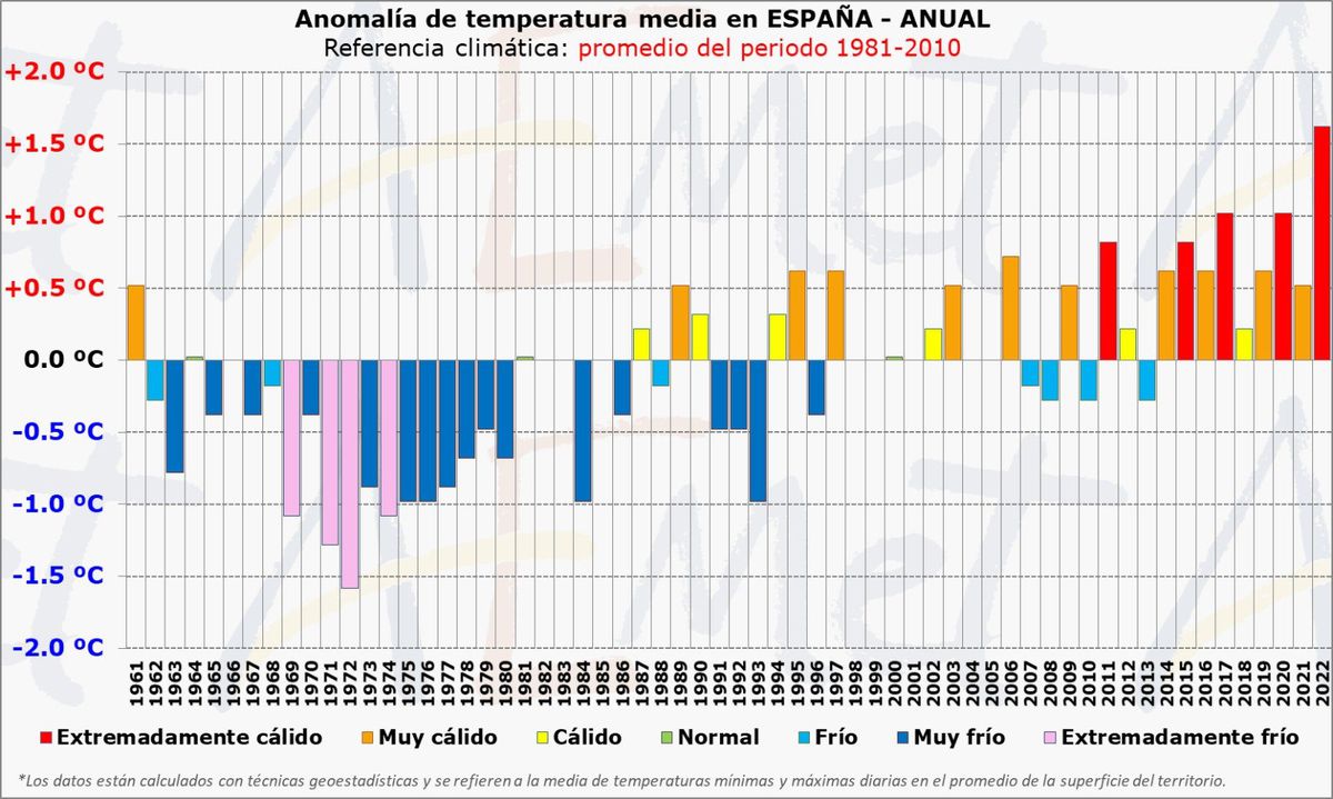
The heat of 2022 is unprecedented in Spain.
With 10 days to go until the end of the year and in which temperatures will also be abnormally high, it has become the warmest since there is data.
"It is, with an overwhelming difference, the warmest year in the series, which starts in 1961, but highly reliable climate reconstructions allow us to affirm that it has been warmer for at least more than a century, since 1915," explains the Agency spokesperson. State Meteorology Department (Aemet) Rubén del Campo who, together with Aemet spokeswoman Beatriz Hervella, makes a preliminary analysis of the year, a climate balance for autumn and an advance of the weather expected in the astronomical winter, which begins this Wednesday at 22.48 Spanish peninsular time.
For the first time, the average annual temperature of the country will exceed 15° - at the moment 15,
3°― which means 1.6° above normal.
"Although it may not seem like much, in the whole of the year and of a country, it is a real barbarity," emphasizes Del Campo.
In fact, the previous two warmest years, 2017 and 2020, are very far from the "unprecedented" level of 2022, since they ended tied with one degree more than normal.
Also, 2022 has been a dry year.
From January 1 to December 15, 509 liters per square meter accumulated in Spain, when the average is 608, so it has rained 16% less than usual.
It is provisionally the third driest year in the series, in the absence of counting the rains in the second half of December, which will make it end up surely among the 10 least rainy since 1961.
The direct cause of the heat is that "stable atmospheric situations have predominated throughout the year, sending warm subtropical masses to Spain, which helps autochthonous warming," explains Del Campo.
As a consequence, there have been "more than 10 episodes of high temperatures since May and only one of low temperatures after winter, at the beginning of April", which have left "30 records of warm days -days of higher temperatures in comparison with that of those same days of the month since 1950― compared to only two cold days, April 2 and 3”.
"In an unaltered climate, five warm days and five cold days are to be expected, so this year there have been six times as many warm days," notes the meteorologist.
The year that was closest to the current one was 2021, with 23 warm days.
The root cause is undoubtedly climate change.
"A warm year may be due to the variability of the climate, but the long-term trend is clear, the four warmest years have accumulated in the last decade," emphasizes Del Campo.
"Climate change causes the average temperature to rise and, furthermore, as has been clearly seen this year, it triggers extreme events, in this case those related to heat," he adds.
According to a study signed by the Aemet delegate in Navarra, Pedro Oria, which will be published this weekend on the agency's blog, situations favorable to producing heat waves have doubled since 1950 in Spain in the extended summer, from May to October.
“Global warming not only manifests itself in a warming of the thermodynamic climate system, due to the greater presence of greenhouse gases in the atmosphere, but it is also changing the pattern of atmospheric circulation, increasing the frequency in the warm part of the year of the situations that give rise to heat waves”, contextualizes Del Campo.
There are studies that suggest that this change in atmospheric circulation is due to "Arctic amplification", the three times faster heating of this area of the planet.
All the months of this 2022, except for March and April that were cold, have been "hotter than normal", especially May, July and October, which were extremely hot.
For the first time, and this is a "very outstanding" fact for Del Campo and Hervella, Spain chains two warmest seasons in the series within the same year, summer and autumn, with the latter season tied with that of 1983.
In autumn, which in meteorology includes the months of September, October and November, the average temperature was 16.3°, two degrees more than normal, with October as the warmest month in the series with 3.6° more .
September was warm (0.6° more) and November very warm (1.9° more) and "not a single day" of the entire season has been below 5% of the coldest days, but yes there were several warm episodes, especially in October.
In the east of the Peninsula and in the Balearic Islands, autumn "has been practically an extension of summer".
#RuedaDePrensaAEMET
We take stock of autumn 2022. As for temperatures, it has been the warmest in the historical series, tied with autumn 1983. It has been 2ºC warmer than normal.
The last fall with temperatures below the normal average was in 2010 pic.twitter.com/E08chp5yEY
– AEMET (@AEMET_Esp) December 21, 2022
What awaits the next quarter in Spain in terms of heat is a sum and continues without end.
According to Hervella, winter will be warmer than usual in both archipelagos and in the east of the peninsula, while the quarter will most likely be normal or warm in the rest of Spain.
Rain, but not enough
As for the rains, this autumn an average of 152 liters have been collected, 24% less than usual in that season of the year, so it was "very dry", the third driest in the 21st century.
This lack of rainfall meant that "Spain continued in a meteorological drought at the end of November —continued lack of rainfall— and was on the verge of entering a socioeconomic drought" or long-term drought after three consecutive years with little rain.
"The abundant and persistent rains in the first half of December have partly, but not totally, alleviated the situation," concludes Del Campo.
Thus, in the hydrological year ―which began on October 1― a water deficit of 23% accumulated until November 29, but since then and until December 19, the situation has turned around and there is a surplus of rainfall of 4%.
In the swamps, it has resulted in a spectacular increase of 6.3% (3,531 cubic hectometres) in the water reserve, which was at 42% capacity this Tuesday, with 23,552 cubic hectometres, according to data from the Ministry for the Ecological transition.
However, to get out of the meteorological drought "it would have to continue raining abundantly" throughout the winter, meteorologists point out.
And will it?
The seasonal forecast does not show a clear long-term trend, but short-term forecasts point to little rain for the next two weeks.
Subscribe to continue reading
Read without limits
Keep reading
I'm already a subscriber