What happens in this corner of the eastern Mediterranean?
Well, there is the confluence of four tectonic plates, those of Anatolia, Arabian, Eurasian and African;
those moving pieces of the puzzle that make up the terrestrial lithosphere.
The anvil-shaped Anatolian Plate is pushed down to the east by the Arabian Plate, to the north by the Eurasian Plate, and to the south by the African Plate.
The slow and gradual movement of the tectonic plates causes the accumulation of significant stresses at their edges that progressively deform the crustal rocks until they fracture.
It is the faults, those sutures of weakness, that can instantly release large amounts of accumulated elastic energy, causing an earthquake.
Turkey is one of the most seismically active regions in the world because it is crossed by two major faults: the North Anatolian fault, which borders the Eurasian plate, and extends from the Armenian plateau to the Marmara Sea;
and the eastern Anatolian fault, which borders the Arabian plate, and which somewhat draws Turkey's border with Syria until it connects with the Cyprus arc.
Both faults are very long (1,000 km and 700 km, respectively), which determines that they can produce large-magnitude earthquakes (size does matter).
In addition, they are transform faults, which in geological jargon means that the tectonic plates move laterally with respect to each other.
To make matters worse, in transform faults earthquakes tend to be more superficial,
which can make them more dangerous and harmful.
A very famous example of a transform fault is the San Andrés fault, which runs for 1,300 kilometers from Mexico to Oregon, and where the Pacific and North American plates meet;
another zone of great earthquakes.
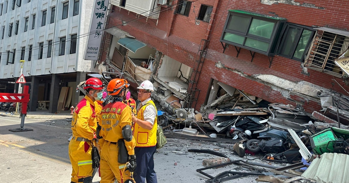
The epicenters of this week's earthquakes are located on the eastern Anatolian fault line.
The largest of them (magnitude 7.8) had its epicenter located in a southern segment of this fault, near the border with Syria.
Hours later, the second (magnitude 7.5) arrived, located further north, in another segment of the aforementioned fault.
If one looks at the arrangement of the many aftershocks that have taken place, one will see that they are aligned along these two segments of the East Anatolian fault, following a tectonic path that is also marked by the mountain ranges of south-eastern Turkey.
The landscape is a reflection of the geology.
As a general rule, earthquakes are recurrent on the same fault, that is, they are repetitive.
As soon as one ends, the continuous movement of the tectonic plates again accumulates tensions and deforms the rocks, until the next break.
This is the story of old Anatolia, which has 50 earthquakes of magnitude equal to or greater than 6 during the last 100 years.
The marks of great earthquakes are in the vast cultural heritage of Turkey and in the memory of its people.
As an example of geological adaptation, remember the advanced anti-seismic design of Hagia Sophia in Istanbul, which has survived more than 1,500 years of earthquakes.
In the world, more than 300,000 earthquakes occur every year that can be perceived by the population.
Of these, only a few are of great magnitude and can cause extensive damage and fatalities when they occur in populated regions.
Unfortunately, this is what has happened in the border area of Turkey and Syria, one of the most dangerous seismic places on Earth.
More information
Turkey and Syria earthquakes, last minute live
Are there geological contexts similar to Anatolia?
Japan could well represent one of them, with several tectonic plates (also four) converging in the Pacific.
In our recent memory, the Kobe (1995) and Töhoku (2011) earthquakes still persist, the latter with a devastating tsunami that devastated the northeast coast of Japan, causing the Fukushima nuclear tragedy.
The English geologist Derek V. Ager said that "the history of the Earth is like the life of a soldier, long periods of boredom and brief moments of terror."
There are places on our planet where moments of terror are more frequent;
moments that unfortunately remind us of human fragility in the face of the force of terrestrial dynamics.
Rosa María Mateos
is a Research Professor at the National Geological and Mining Institute of Spain of the CSIC.
We answer
is a weekly scientific consultation, sponsored by the
Dr. Antoni Esteve Foundation
and the
L'Oréal-Unesco 'For Women in Science' program
, which answers readers' questions about science and technology.
They are scientists and technologists, members of
AMIT (Association of Women Researchers and Technologists)
, who answer these questions.
Send your questions to
us@gmail.com
or on Twitter #weanswer.
You can follow
MATERIA
on
,
and
, or sign up here to receive
our weekly newsletter
.
Subscribe to continue reading
Read without limits
Keep reading
I'm already a subscriber


/cloudfront-eu-central-1.images.arcpublishing.com/prisa/E2SOPDAIKRGJPJY4T2WETDP77I.jpg)