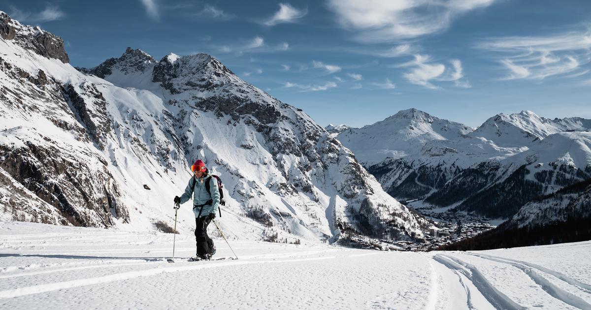
Val d'Isère, in the Vanoise massif (Savoie)
Nestled at the bottom of the valley, at the gates of the Vanoise National Park, the sporty and snowy Val d'Isère invites you to explore the great outdoors.
Before going off the beaten track, these two routes promise hikers great escapes in a purely “downstream” setting!
Number of permanent secure routes: 2
La Brinzeï (distance: 2, 16 km, Elevation: 355m)
This new track starts at the foot of the La Daille cable car.
It then plunges hikers into a larch forest before crossing a bridge over the beautiful Vallée Perdue and its snowy ruins.
A first exit allows you to connect to the La Verte slope, those who still have the breath will continue the ascent to the foot of the Tommeuses chairlift for a drop of 450 m!
L'Écureuil (distance 1.81 km, elevation gain: 425m)
A pretty climb on the Solaise massif passing through the Rogoney forest.
Some slightly steep passages will require hikers to make conversions... enough to improve their technique!
The climb ends at the foot of the red Plan run on the Solaise massif.
Read alsoVal-d'Isère: everything for skiing... Or almost!
Convenient
The two routes are indicated on the piste map, but also available on the "On Piste" application, which allows you to geolocate and be guided throughout the route.
Take on the Avaline Trax challenge.
: this night race to be done alone or in a group takes place in winter: in January, February and March.
It is also possible to participate without the stopwatch, simply to take advantage of the safe night climb to the Folie Douce and the aperitif offered there.
More info: valsport.org
Val d'Isère Tourist Office, place Jacques Mouflier, 73150 Val-d'Isère.
Such.
: 04 79 06 06 60.
Read alsoIn Val-d'Isère, accommodation with all-inclusive service
Avoriaz, in the Chablais massif (Haute-Savoie)
Night hike on the top of the Lindarets ridges.
Loic Bouchet / Avoriaz
The atypical resort perched above its cliff offers a fine range of routes.
Panoramic, sporty or both at the same time... the playground to be surveyed at the gates of the Swiss summits will not tire anyone.
Number of permanent routes: 3
Le Vanné (distance 4 km; height difference: 305 m)
Departing from the Ardent gondola or from the village of Lindarets, this easy route is ideal for beginners and enjoying the scenery.
Once through the forest, hikers reach the summit of the Lindarets ridges and enjoy an exceptional panorama of the Chablais massif… Unique at sunset!
Les Jordières (distance 3.2 km; difference in altitude: 606 m)
This course is appreciated on days of low visibility because it is mainly in the forest.
From the departure of the Prodains cable car and passing through the Crêt mountain pasture and its chalets, this is the most sporty route in the resort.
The Crêtes d'Arare (distance 2 km; height difference 470 m)
Starting from the top of the Prodains cable car, hikers are guaranteed a visual spectacle all along the route.
View of Avoriaz, then of the Ardoisières valley before reaching the final ridge and visually reaching the mythical Dents Blanches on the Swiss side!
The descent is à la carte: blue, black or off-piste runs.
Avoriaz 1800 Tourist Office, 44 Prom.
du Festival, 74110 Morzine.
Such.
: 04 50 74 02 11.
Read alsoFrom Morzine-Avoriaz to Morgins, our essential skis at the foot of the Portes du Soleil
Orcières-Merlette, in the Écrins massif (Hautes-Alpes)
In Orcières-Merlette (Hautes-Alpes), the southern light illuminates the high peaks of the Écrins.
Gilles Baron
Number of permanent secure routes: 2
At the gates of the Ecrins National Park, the wild sector of Haut Champsaur attracts many fans of sealskin with great classics culminating at 3000 m altitude such as Mourre Froid (2993 m) or old Chaillol (3163 m) .
The resort of Orcières-Merlette may be very family-friendly, but it does not forget sports enthusiasts!
Two routes are available to new hikers wishing to experience the activity, alone or accompanied.
Read alsoSki touring: the guide to getting started
Pointe de Méolion (distance 3.4 km; height difference 624 m)
From the Flags snow front, once you have crossed the Bois de Montagnou and its Melèzes, the view overlooking the beautiful Champsaur valley faces the summits of Barle, Aiguille d'Orcières and Garabrut.
The arrival of the route is at an altitude of 2474 m, at Pointe Méollion, with a well-deserved 360° panorama.
The descent is done by the blue slopes "Les Vallons" then "Montagnou".
Lac des Estaris (Distance: 4.6 km; elevation gain: 712 m)
This course with rather gentle relief allows you to contemplate the varied landscape at leisure.
Frozen lakes, rocky bars of Rochebrune, white immensity of the Jujal plateau….
The route is shared with pedestrians up to the Rocherousse plateau, before being specific to cross-country skiers via beautiful panoramic crossings.
The arrival takes place at the top of the chairlift of Estaris which overhangs the eponymous lake, and the descent is done by the blue run “Sirenes”.
Convenient
A topoguide with the descriptions of the routes, the conditions of practice and safety is accessible online on the website of the tourist office.
It also lists the guide and instructor service providers offering supervision of the activity and the many specifically equipped equipment rental companies.
Orcières Tourist Office, Place desflags - Merlette
05170 Orcières.
Such.
: 04 92 55 89 89.
Read alsoSki touring: the best spots of Kilian Jornet
Arêches-Beaufort, in the Beaufortain massif (Savoie)
Arêches Beaufort, the Mecca of ski touring.
Outdoor spirits
Number of permanent marked routes: 4
This village, located 20 km from Albertville, is not only known for its cheese: Arêches-Beaufort is to ski touring what Chamonix is to mountaineering.
In this temple of sealskin, the pilgrimage traditionally takes place in March during the famous Pierra-Menta, a ski mountaineering race where the whole resort mobilizes and vibrates for those thirsty for elevation changes from all walks of life.
This culture of mountain skiing has always been aimed at both elites and neophytes.
Thus, on the estate, there are four permanent routes that are open to the public.
Ultimate objective for beginners, the “Traces” (blue, red and black) also serve as launching pads for hikers with big hearts setting off to attack the Grand-Mont or other famous classics.
Read alsoSki touring: why Combloux is the ideal resort to get started
The Blue Trace (distance 2 km; elevation gain 300 m)
Access is from the Bonnets Rouges chairlift in the Grand-Mont sector.
The open and gently sloping path offers a panoramic view and allows you to reach the top of the ski area, at the Col de la Forclaz, at an altitude of 2320 m.
The descent is then done by the blue Perdrix run.
La Trace Rouge (distance 2.5 km; elevation gain 320 m)
More technical, this route is taken from the Cuvy plateau to the start of the blue route, thus allowing the linking of these two Traces.
The descent is done on the blue Bonnets Rouges run.
La Trace Pro (distance 3 km; elevation gain 900 m)
As you will have understood, this route which starts at the start of Le Planay and climbs to the top of the Grande Combe, is reserved for trained hikers!
The first part is in the forest then the frame opens up and offers on arrival the view of the Pierra-Menta.
Descent via the Pas des Vaches red run and the Echarté blue run.
La Trace Nocturne (distance 1.5 km; elevation gain 350 m)
After the slopes close and until 8 p.m., the Echarté blue slope in the Planay sector turns into a route uphill with the headlamp to the chalet located above beacon 13. The descent is made by the same track.
Convenient
Every Monday evening, the Arêches Dynafit Experiences allow beginners to be accompanied by professionals for 1 hour 30 minutes in a small group.
Price: €40, equipment included.
Arêches-Beaufort Tourist Office, 120 Route du Grand-Mont, 73270 Beaufort.
Such.
: 04 79 38 15 33. Specific packages (one or two simple chairlift rides to access Les Traces or “classic” routes such as the Grand Mont) are available to hikers from €6.90 at the lift ticket offices. mechanics or on the website of the tourist office.
ESF Arêches-Beaufort, place du Capitaine-Bulle, 73270 Beaufort/Doron.
Such.
: 04 79 38 10 99.
House of Beaufortain Guides.
Such.
: 06 48 90 49 39. The Maison des Guides du Beaufortain and the French Ski School offer initiations every day of the week, or on request, as well as free training in the search for avalanche victims.
Read alsoSavoie: our best family hotels to book in ski resorts
Courchevel, in the Vanoise massif (Savoie)
Courchevel is a pioneer in the provision of a groomed and safe climbing track.
patrick pachod
Number of permanent marked routes: 5
In 2012, Courchevel was the first French resort to offer a safe ascent track for ski touring.
Because the 3 Valleys resort counts among its fans many enthusiasts of endurance sports and skiers in search of escape.
Up there, sealskin outings and wild off-piste trails like in the secret Vallon des Avals and many other routes in the heart of the Vanoise National Park are within easy reach and well known to local guides and instructors.
Thus, to learn before diving into these wide open spaces, apprentice hikers will find throughout the winter, during the opening hours of the domain, these 5 marked routes, with a view of Mont-Blanc at each of the arrivals. .
Read alsoFrom Megève to Val Thorens, mountain hotels tested by Le Figaro
La Millet Ski Touring (distance 3.2 km; elevation gain 500 m)
Located at the start of Courchevel Le Praz, the calm and bucolic itinerary is mainly through the forest to lead to … the famous Croisette in Courchevel 1850!
La Plum KV (distance 5 km; elevation gain 1,000 m)
Hang on, this route from Courchevel Le Praz to the Loze relay represents one Vertical Kilometer, or 1000 meters of elevation!
As a gift, a panorama over the entire Courchevel valley with the Gand Bec, the Vanoise glaciers and the Grande Casse on one side and the Méribel valley on the other.
The Plum MOONtain Race (distance 4.8km; elevation gain 920m)
From Courchevel Village to the famous Col de la Loze, this route is also that of the race of the same name, which takes place in winter and summer on full moon nights!
This pass also welcomes the arrival of the Col Cyclable which connects Courchevel to Méribel in summer.
The Géné'piste (distance 2.8 km; elevation gain 528 m)
Wilder, and just as panoramic, this route starts from the aptly named Belvédère district in Courchevel Moriond, up to the Ariondaz signal at an altitude of 2250m which faces the Portetta breach, a famous dolomitic-looking rock.
Praméruel (distance 4 km; elevation gain 610 m)
Departing from Courchevel Village, this route runs along the Pramaruel stream in the Ban woods, then leads to the open Creux sector, above the altiport, with a breathtaking view.
Convenient
In an atmosphere as friendly as it is sporty, the Millet Ski Touring races punctuate the season.
These nights mix the general public with the elite, all attacking the summit.
For the last race of the winter, everyone is in skins and disguised.
Information: courchevelsportsoutdoor.com.
Courchevel Tourist Office, 110 Rue de la Croisette, 73120 Courchevel.
Such.
: 04 79 08 00 29.
Read alsoCourchevel ski touring version, far from the bling-bling
La Plagne, in the Vanoise massif (Savoie)
The call of the forest, skins on your feet, in Champagny en Vanoise.
Elina Sirparanta
Number of permanent secure routes: 7
La Plagne caters to both beginners and more experienced hikers and ensures that visitors located in one of its 12 sites will find a route nearby.
Between the silence of the Montchavin forest and the high mountain atmosphere of the Col de Forcle, the atmospheres are also very varied and promise very different experiences.
To make the right choice and be sure to follow the right path, a precise topoguide is available to the public at the Tourist Office and at the resort's information points, and of course, guides and instructors are available.
Read alsoThe H036 hotel in La Plagne, the expert opinion of Le Figaro
Among the 7 itineraries, two routes are particularly worth the detour:
Champagny - La Porcière (distance 6 km; elevation gain 930 m)
From the bottom of the Champagny en Vanoise gondola, this route is the longest offered in La Plagne!
The climb, varied, alternates passages in hamlets, then in a beautiful coomb before plunging into the forest.
The view of the Grand Bec and the Vanoise glaciers leaves no one indifferent, and the descent takes place on the famous red run of Mont de la Guerre with its wild atmosphere.
Plagne Bellecôte – Col de Forcle;
(distance 5 km; elevation gain 350 m)
This course is ideal for beginners because it offers groomed portions and others off-piste to familiarize yourself with evolution on unprepared snow.
A break on the Dou du Praz plateau and its orientation table allows you to admire the panorama of Mont-Blanc and the surrounding mountains.
The descent can be done by the blue “Ours” run.
The 5 other routes also described in the topoguide:
La Roche - Le Fornelet (distance 3.5 km; elevation gain 485 m)
Les Coches - Plan Bois (distance 3.7 km; elevation gain 390 m)
Plagne Center – Col de Forcle (distance 4 km; elevation gain 350 m)
Montchavin - Les Pierres Blanches (distance 6 km; elevation gain 800 m)
Plagne Montalbert - Le Fornelet (distance 5 km; elevation gain 625 m)
Practical notebook
Guides and Instructors offer tailor-made supervision including technique, deciphering the landscape and the safety aspect.
Some supervisors, such as the Oxygène Ski School, also include the loan of equipment in the service.
List and contacts of the Offices of Guides and Ski Schools on the resort's website.
Several gatherings are also on the winter program such as the Blue Devils on March 20 or Rando by Night on March 31.
La Grande Plagne tourist office, 1355 route d'Aime - Les Provagnes, 73210 La Plagne Tarentaise.
Such.
: 04 79 09 02 01.
Read alsoIn La Plagne, last winter of skiing on the “historic” glacier
Saint-Pierre de Chartreuse, in the
Chartreuse mountain range (Isère)
The heights of the Chartreuse massif, a hiking paradise between Grenoble, Voiron and Chambéry.
c eichinger
Number of permanent secure routes: 3, a specific reception base
A trail destination in summer, the resort with 29 mid-altitude peaks near Grenoble has made ski touring its winter specialty.
It is here that the first ski touring area in Europe was born, a dedicated educational place with a reception base, equipment, showers and changing rooms and all the services of supervision, advice and training offered.
Another plus: the newly reworked mobile application allows access to maps, to read the profile of the routes and practical information with points of interest, timing and good addresses around.
GPS guidance is also possible, even offline.
Three marked and secure routes are therefore accessible to the public, alone or accompanied.
La Scia (distance 6.6 km; elevation gain 779 m)
The start is at the Center Espace Ski de Rando, the route mainly in the forest is ideal for beginners, with a few small technical passages where you can make the famous "conversions", these changes of direction which allow you to climb in zigzag when the slope becomes stronger.
This route offers 4 loopholes, to easily find the track, the descent is possible via a blue, red or black track.
The new variant offers a higher start, from the Essarts site.
The hollow of the snow (distance 2.9 km; elevation gain 625 m)
Starting from the Combe de l'Ours, to the left of the start of the 6-seater chairlift, this route is a classic arriving at the top of the Scia ski lift.
There too, two loopholes allow beginners to descend when their body makes them feel it!
The descent is done by a red or blue track, or via the new variant outside the track!
Le Plattet (distance 2.2 km; elevation gain 495 m)
This route from the place called Baffardière was created in 2023. From the village to the top of the Plattet ski lift, it alternates passages in the forest and through the meadows.
Some technical passages require conversions!
Convenient :
The ESF Chartreuse offers neophytes an “ABC of ski touring” training in small groups of 3 to 5 people for 3.5 hours, from €49/person.
Such.
: 04 76 88 62 87.
Espace Ski de Rando de Chartreuse, 98, Rue Louis Barran
38430 St Jean de Moirans.
Such.
: 04 38 03 82 70.
Read alsoFour hikes to discover the Chartreuse massif, between Isère and Savoie