
The explorers of the 21st century navigate the Internet more easily than by canoe or camel.
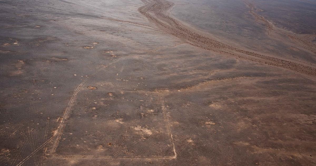
A team of researchers from the University of Oxford have discovered three previously unknown Roman camps after reviewing and analyzing satellite images of the border between Jordan and Saudi Arabia, available on Google Earth.
These new archaeological sites, whose existence was confirmed last November by an aerial photography campaign, are now the subject of a study, published in April in the scientific journal
Antiquity
.
The EAMENA project (Oxford research group dedicated to the archeology of the Middle East and North Africa) "
systematically examines open source satellite imagery, available on platforms such as Google Earth, in order to identify and document archaeological sites",
present in their study the four British archaeologists at the origin of the discovery.
The colossal background of images made available by Google has already made it possible in the past to discover new archaeological sites, in particular in the Amazon.
Read alsoThe pay slip of a Roman soldier discovered at the fortress of Masada
An annexation without a grain of sand
The identification of this network of Roman camps does not satisfy the only curiosity of cartographers of the ancient world.
The discovery reveals a secondary caravan route, which linked the site of Bayir, in Jordan, to the Nabataean city of Dûmat al-Jandal, in the north of present-day Saudi Arabia.
The Roman forces would have taken this path to quickly invest the Nabataean kingdom after the death in 106 of its last king, Rabbel II.
Given the appearance and size of the camps, British researchers believe that the Roman troops engaged on this axis must have been made up of one or two mounted cohorts.
And possibly equipped with camels.
Read alsoMysterious Egyptian antiquities from Amiens came from the Saqqara necropolis
“The state of preservation of these camps is truly remarkable, especially since they may have only been occupied for a few days or weeks at most
,” enthuses Michael Fradley, the lead author of the book. study, in a press release from the University of Oxford.
According to the archaeologist, the position of these country forts, located in the middle of the desert, could also provide an indication of the organization of the Roman conquest of the caravan kingdom, whose historic seat was in Petra.
The passage by this road
"suggests a strategy of bypassing the busier route of Wadi Sirhan, which could have added an element of surprise to the Roman offensive",
thus advances Michael Fradley.
The annexation of the Nabataean Kingdom dates back to one of the many campaigns of Emperor Trajan, who ruled the Roman Empire from 98 to 117. The invasion itself met, according to historians, with little or no resistance. .
It ends with the creation of a province of Arabia on the margins of the Roman world and the Mediterranean.
For Andrew Wilson, who also signed the study published in
Antiquity
, the discovery of these new camps could however indicate that this minor conquest may not have been as easy as one imagines.
An archaeological excavation campaign - the old-fashioned way, rather than digital - could one day help to find out more.
/cloudfront-eu-central-1.images.arcpublishing.com/prisa/YAS3TNGA5BE5HP6LPTTHYXGNGQ.jpg)


/cloudfront-eu-central-1.images.arcpublishing.com/prisa/KMEYMJKESBAZBE4MRBAM4TGHIQ.jpg)


