
The balance of the State Meteorological Agency (Aemet) of this April certifies what had already been announced throughout the month, in which week after week abnormally high temperatures have been recorded, until the final firecracker in the thermometers, and tremendously scarce rains. After analyzing the data, Aemet climatologists have concluded that it was the "most extremely hot and dry" April since unified and reliable records exist, 1961.
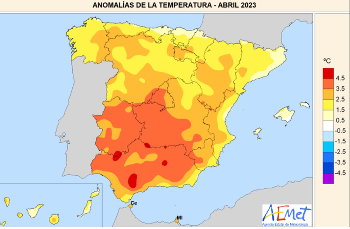
The average temperature, that is, between the maximum and the minimum, has stood at 14.9° in mainland Spain, an astonishing figure that is three degrees above the average for the month. And that the ceiling of the most infernal April so far, that of 2011, was very high: this month it has exceeded that anomaly by 0.1°. As data, in May the average temperature is 15.6 °. Although far from the peninsular level, the Balearic Islands and the Canary Islands have also suffered a "very warm" month, with 0.8° and 1.9° above the average. For its part, the average rainfall on mainland Spain has been 14.2 liters per square meter, just 22% of the expected rainfall.
More information
April's record heat would have been "extremely unlikely" without warming
In the map of the scorching heat, they lose the interior of Andalusia, the east of Extremadura and southwest of Castilla-La Mancha, where the anomaly of the average temperature has been around 4° more, almost 5° in some areas of these three communities. Even in areas that are not very suspicious, such as the peak of Navacerrada (Madrid), the thermometers have been 4.5° above what they should be. Areas of the eastern Cantabrian Sea and the coasts of Catalonia and the Valencian Community have barely been saved from the Iberian oven, where they have spent the month only 1° too much.
In 30 of the 93 stations of the main network of Aemet, the average temperature was "the highest of an April since there are records". At 45, the average of the maximums was the highest in the monthly series. And the worst have been the maximums, which stood at an average of 22.6 ° and climbed to 4.7 ° above the normal value, with Jaén at 6.8 ° above, Córdoba at 6.5 °, Cuenca and Morón de la Frontera (Seville) at 6.4 °, and even Soria at 4.8 °. However, the minimums did not shoot up so much and there were even frosts in inland areas, so they ended up only 1.3 ° above. Thus, in four stations the average of the minimums was exceeded and there were tropical nights, in which the thermometers do not fall below 20° in Jaén, Cáceres, Cádiz and Palma.
In the main observatories of Aemet, 58 records of maximum and minimum have been broken, in some cases, such as that of the airport of Córdoba, three consecutive days. Of these marks, Aemet highlights the last of the three records of Córdoba, 38.8°, which became the highest temperature ever measured in the Peninsula and the Balearic Islands in April, followed by 37.4° of Morón, and 36.9° of the aerodromes of Granada and Seville, all of them on the 27th, at the peak of the extreme heat episode.
The meteorologist of Eltiempo.es Roberto Granda makes a more complete balance of records, since it includes the stations of the secondary network and eliminates the ephemeris exceeded several times. Only during the five days that the extreme episode lasted, 193 records were broken, while 200 are exceeded taking into account the whole month. Granda highlights to this newspaper that the communities in which the most records have fallen are Andalusia, Extremadura, Madrid, Castilla-la Mancha, Castilla y León, while La Rioja and the Basque Country are the only ones in which the heat marks have not been exceeded.
"Cordoba has spent 17 days above 30 ° and four above 35 °, which had never been seen in April, while cities such as Valladolid, Cuenca and Soria have experienced their first 30 ° this month," notes this expert, for whom "there is no way to describe what happened, with records that are broken by four and five degrees, It's a real savagery." Last Friday, experts from the World Weather Attribution (WWA) ruled that these values would have been "extremely unlikely" without anthropogenic climate change, which makes this episode at least 100 times more likely than in a climate not altered by the hand of man.
However, despite the fact that the mass of air of African origin arriving at the Peninsula was the warmest at this time in at least 43 years, finally it was not the worst heat episode recorded in April since there are data, already in according to Cayetano Torres, responsible for Communication of Aemet, "in average temperature equaled that of 2011, although in the average of the maximums it is a record".
After this April, which came after the fifth consecutive warm winter and the second warmest March of the century, the agency's forecasts are not good. For the May-June-July quarter, there is a greater probability that it will be warmer than normal throughout Spain, with greater forcefulness in the east of the peninsula, the Balearic Islands and the Canary Islands.
As for the rains, absolute desolation. "100% of the Peninsula had more hours of sunshine than normal, with 320 hours on average, so it has turned out to be the sunniest month in the period 1983-2023 surpassing the year 2017, in which the average was 294," says climatologist and researcher Dominic Royé. The result is that the month has had an "extremely dry" character in the classification of Aemet, in fact "the driest since the beginning of the series in 1961", with an average rainfall over mainland Spain of 14.2 liters, which is only 22% of the normal value of the month.
Map of the percentage of precipitation collected in Spain in the month of April with respect to the average. AEMET
In the Balearic Islands, 16.9 liters have been collected and in the Canary Islands, 3.5, so there it has been "very dry", one step below that in the rest of the country. Between dry and normal it has ended in Galicia, northern Catalonia, points of Castilla y León, northern Navarre, northeast of the Basque Country, coastal areas of Murcia and the eastern Canary Islands. In no area of the country has it been rainy and in 14 main stations of the Peninsula it has been the driest April since there are data.
"Among all the ephemeris, the scarce liter that has fallen in the Albacete observatory and the 0.4 of Granada and Valencia stand out," says one of the spokesmen of Aemet, Ricardo Torrijo. Since the beginning of the hydrological year, on October 1, until May 2, an average of 346 liters have been collected, 26% less than the normal value, which deepens the long-term drought situation in which Spain entered in December and from which it will not leave at least until the autumn.
Two more days of heat and thermal decline on Wednesday
The good news is that the intense heat that has continued to make the first days of May, with values more typical of June than of this time of year, will give way from Wednesday to several milder days, to the point that March temperatures will return in areas of the north of the peninsula. Thus, the thermometers will continue this Monday and Tuesday between 5 ° and 10 ° above normal in much of the peninsular interior, with 30 ° in much of the interior and up to 35 ° in the southern half, but that on Wednesday there will be a generalized thermal decrease of up to 10 °, which will extend in large areas until Friday, when the whole country, except the Canary Islands and the peninsular southwest, will have temperatures lower than normal.
On Friday, usual values are expected in mid-March in Vitoria (13°), Pamplona (15°) and Logroño (16°), but 30° persists in Córdoba and 32° in Seville. As for the rains, they will be weak, in some cases accompanied by storms, and will be restricted to Galicia, the Cantabrian communities and the Pyrenees, and will appear Tuesday, Wednesday and Thursday in the northeast of Catalonia. For the weekend, a new rise in temperatures is expected, although slight.
You can follow CLIMA Y MEDIO AMBIENTE on Facebook and Twitter, or sign up here to receive our weekly newsletter