
It would be, no more and no less, a new Viking age. Or, at least, a nice series of discoveries. Norwegian archaeologists from the University of Stavanger announced in late April that they had identified an early Viking Age Scandinavian ship in the bowels of the Salhushaugen mound in Karmøy, southwest Norway. The discovery, made in June 2022 and kept secret for nearly a year, was concluded at the end of a geophysical prospecting campaign. The generalization of this device has revolutionized archaeological research in Norway in recent years.
"This new find is part of a series of ship discoveries made in recent years," researcher Christian Løchsen Rødsrud told Norwegian science media Forskning. The archaeologist knows his stuff. In 2020-2021, he oversaw the excavation campaign of the Viking ship of Gjellestad identified in 2018 near a famous mound in southern Norway. And in Gjellestad as in Salhushaugen, the excavators can thank a strange tool, sometimes similar to a lawnmower, sometimes to an agricultural tractor: a ground-penetrating radar.
" READ ALSO An Egyptian documentary on "the real Cleopatra" comes out to compete with that of Netflix
Refined over the past fifteen years in the field of archaeology, the geophysical prospecting method makes it possible to scan a terrain and detect, without digging, objects and structures buried below the surface. The scanning tool, ground-penetrating radar, can be refined to capture variations in electrical potential or, for example, to measure contrasts in the Earth's magnetic field.
A ground-penetrating radar survey in Gjellestad in 2018. The Viking ship was discovered in the immediate vicinity of a known Scandinavian mound. Erich Nau, Norsk institutt for kulturminneforskning
In the case of the Viking ship discovered at Karmøy, Norwegian surveys were intended to complement the excavations carried out at the same location in 1904. At the time, archaeologist Haakon Shetelig probed the Salhushaugen mound without much success. The site, however, seemed very promising to him, since it was close to the place where Grønhaugskipet's ships were exhumed and, above all, Oseberg - the most imposing Viking ship preserved today. More than a century later, researchers at the University of Stavanger were able to show that their predecessor had simply excavated too timidly.
See alsoNeanderthal has not changed its hunting strategy, despite climate change
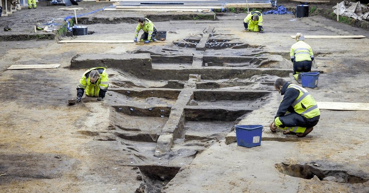
"The GPR signals clearly show the shape of a 20-metre-long ship, a fairly large diameter reminiscent of Oseberg," Håkon Reiersen, head of the archaeological operation, told Forskning. The location of the ship, in the heart of the mound, also seems to indicate that it was in all likelihood a ship-grave. Now collapsed, the original tumulus must have been nearly 50 meters in diameter, for five to six meters high, according to archaeologists' estimates. The ensemble was to constitute the prestigious burial of a person of high rank, who died at the end of the eighth century. That is, at the beginning of the Viking Age.
The search of the Salhushaugen ship is not currently on the agenda. This does not mean that it will not one day be undertaken. Gjellestad's ship was exhumed two years after it was identified due to its deteriorating condition. For Norwegian researchers, however, the main thing lies elsewhere. Salhushaugen, Edøy, Borre, Jarlsberg and Gjellestad: Viking ship discoveries have multiplied in Norway in recent years.
Geophysics not automatic
Joined by Le Figaro, Guillaume Hulin, a geophysicist specializing in archaeology, indicates that this wave could result from an increasing institutionalization of this method of prospecting since the mid-2010s. "There was a real revolution during the 2000s in the field of geophysics applied to archaeology; it is due to the democratization of GPS as well as the rise of computer science, essential for the efficient processing of a large volume of data, explains the specialist, in charge of the geophysics and remote sensing unit of Inrap. More recently, the technique has been adopted by major research centres."
The footprint of the Viking ship from Salhushaugen, Karmøy, revealed by radar imagery in 2022, and presented in April by Norwegian researchers from the University of Stavanger. Museum of Archaeology, University of Stavanger
In the Norwegian case, Guillaume Hulin notes that his colleagues can count on a soil nature that is very suitable for detection by georadar. "The method works well, but only in very specific cases," says the researcher. Radar - the most accurate geophysical technique of the moment - does not adapt very well to clay soils, even in small quantities. In England or Norway, it works very well, because the soils are rather granite; This is not the case in France, alas, where clay is omnipresent." As a result, more than a hundred specialists systematically participate in preventive excavations conducted in the British archipelago, against fifteen geophysicists in France, mobilized more punctually.
See alsoThree Roman camps from the time of Trajan discovered thanks to Google Earth in the Jordanian desert
"Under optimal conditions, the tool can identify an object ten or even fifteen meters deep, but as soon as the earth plays against us, it becomes difficult to see more than a few centimeters," says Guillaume Hulin. The geophysicist says that in 2020, the radar used on the archaeological site of Notre-Dame de Paris had not identified the lead sarcophagi, buried about one meter from the ground under the crossing of the transept. In the aisles, on the other hand, archaeologists were able to scrutinize the depths of the cathedral for more than three meters.
In Norway, however, revisiting sites already known to archaeology has so far proved fruitful. "Our work seems to have paved the way for a new generation of archaeologists to take a renewed interest in these burial mounds," says Christian Løchsen Rødsrud. The race for Viking ships – and other remains that may have escaped archaeologists' pickaxes – is well and truly on.