The oldest map in Europe has spent more than a century, buried and forgotten by all in the reserves of the Museum of National Archaeology of Saint-Germain-en-Laye; its Middle Eastern ancestors waited nine millennia under the harsh sun of the Arab-Jordanian desert. Archaeologists have discovered, engraved on the stone, what they believe to be the oldest known plans, in this case those of huge structures built for hunting.
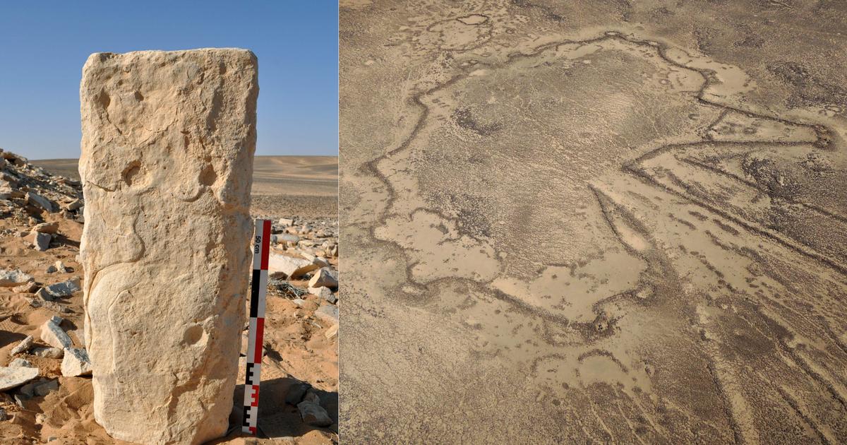
What was represented at that time, before the first city-states emerged from the sands and waters of the Fertile Crescent? "Desert kites" in English. So named by their first discoverers - aviators in the 1920s. These singularly shaped structures are delimited by low walls which, seen from the sky, look like kite trains. The constructions "lead to an enclosed space of about one hectare, where are dugpitsseveral meters deep," describes Olivier Barge, archaeologist and cartographer at the Archéorient laboratory of the University of Lyon-2.
See alsoThe first love kisses described 4500 years ago in Mesopotamia
The Globalkites project, organized by Archéorient, lists to date more than 6000 structures of this kind, from Kazakhstan to Jordan. These constructions allowed a "sophisticated hunting technique". The animals - gazelles for example - were herded into this kind of trap before being directed to the pits to slaughter them. It is near such "desert kites", located in Jordan and Saudi Arabia, that the team of archaeologists of the laboratory made in 2015 two "exceptional discoveries", in the words of Olivier Barge, co-author of the study devoted to this subject and published this month in the scientific journal PLOS One.
We would be unable to render the plan of the "kite" with the precision as is the case here.
Wael Abu-Azizeh, archaeologist at the French Institute of the Near East
A blond limestone stele almost a meter high in Jordan and an imposing block of black sandstone in Arabia both bear the engraved and detailed plans of neighboring "desert kites," the researchers observed, after careful examination of their surface. These plans are not a simple schematic representation, says Wael Abu-Azizeh, archaeologist at the French Institute of the Near East and co-author of the study.
" READ ALSO In Norway, a girl discovers a dagger of the late Neolithic in his schoolyard
The precision of their layout stunned archaeologists. Without the help of modern techniques, "we would be unable to render the planof the kite with the precision as is the case here," says Wael Abu-Azizeh. Drawing a plan to scale implies a control of the proportions of the elements represented, and therefore their precise measurement. A challenge, in the case of structures whose overall shape cannot be grasped without observing it from the air. "We have no idea how they did it," abounds Olivier Barge, whose study highlights "the largely underestimated mental mastery of perception of space" of the populations of the time.
New horizon of prehistoric maps
Until now, the hypothesis was that the art of cartography must have been born much later, in "a culture mastering writing, with a tradition of archives, integrated intonetworks of exchange," continues the cartographer. Like that of Mesopotamia, 5000 years ago.
" READ ALSO In Pompeii, two new victims of Vesuvius discovered in the House of chaste lovers
The discoveries of Jordan and Saudi Arabia reshuffle the situation on the subject. The mega-structures are built in a complex topography, excluding the idea of an initial plan that would then be restored on the ground. This plan made it possible to "transmit information, and share it withseveral people, for the organization of the hunt," says Wael Abu-Azizeh, for whom it is the hypothesis "mostlikely".
There would be a cultural dimension. The map would then be a symbol of the mastery of space and a particular hunting technique, through traps cleverly constructed using the peculiarities of the terrain.

/cloudfront-eu-central-1.images.arcpublishing.com/prisa/5CYUPDL33BHRNA5AWKOZ3OGFK4.JPG)