
It's nighttime, a fat moon reflects off the Beagle Channel, also called the Onashaga in the native language. The explorers are fine-tuning the final details of the journey that will take Cristian Donoso (47 years old), Camilo Hornauer (44), Harry Brito (34), Cristóbal Clement (24) and the captain of the boat, Jorge Caros, to the Cattigara glacier in the Spanish fjord, four hours away by speedboat from Puerto Navarino. They go to the southernmost part of Chile, the end of the world, Tierra del Fuego.
Clement wraps oatmeal mixed with baby cereal in 200-gram portions. They will eat, as in every exploration, one day oatmeal and another day ravioli. It will be their only food when, after reaching the Cattigara, they attempt to ascend Mount Darwin.
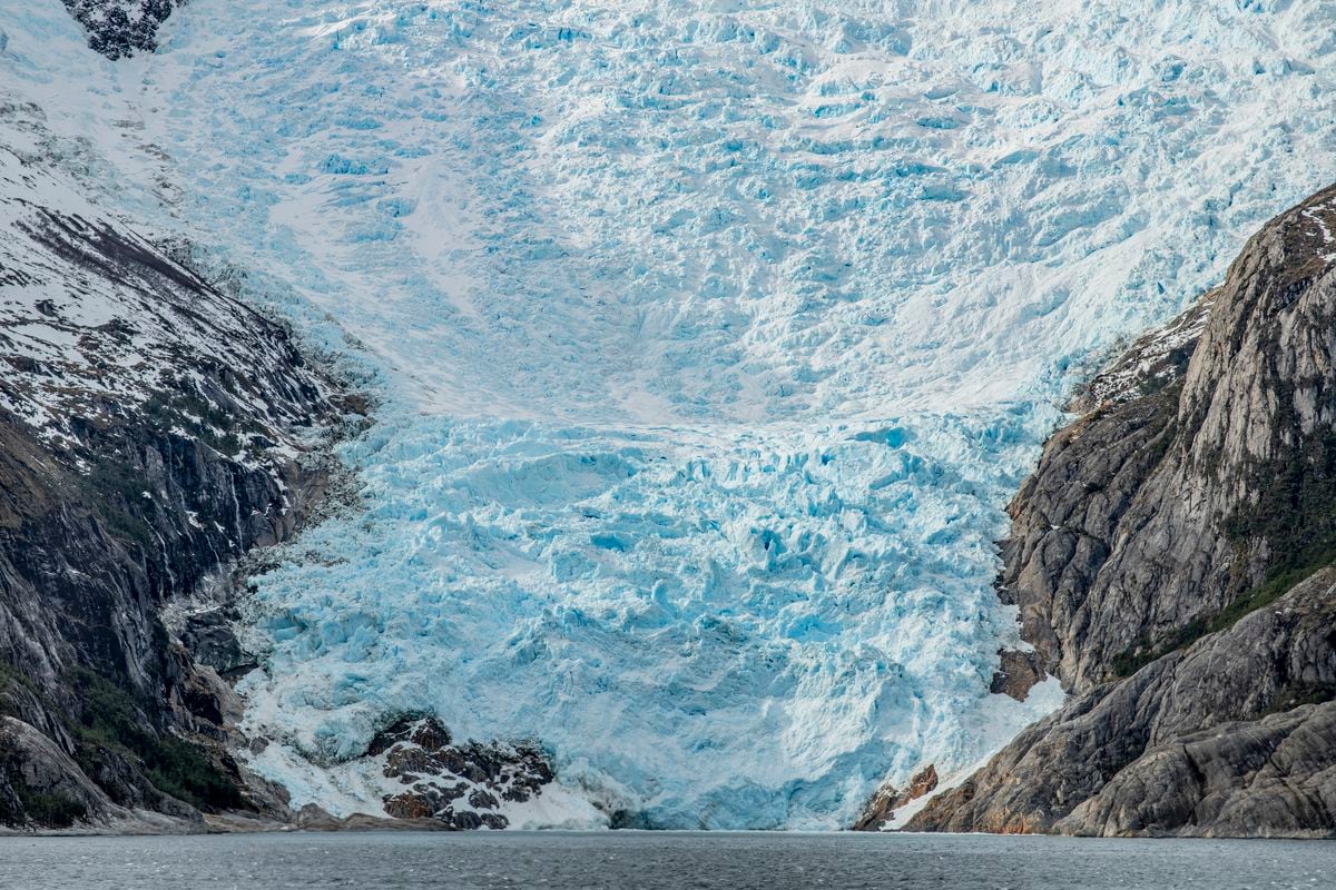
Explorer Cristian Donoso, at the landing site on the shores of the Spanish Fjord in the Darwin Mountain Range, southern Chile.Tomás Munita
"It's simpler. It's going well and we're forgetting about hunger," says Donoso, an explorer with more than 100 extreme routes in Antarctica and Patagonia behind him and leader of the current expedition that, this time, will repeat the journey and photos taken in 1962 by Chilean geologist Cedomir Marangunic and English mountaineer Eric Shipton on a trip with other colleagues.
"And the water?" What will they take?
"Melted snow."
The team knows the demands. On each route, they usually lose about 17 kilos because they walk between 10 and 15 hours a day, carrying 200 kilos of photographic equipment, food and shelter.
"There are days when we climb more and others less, depending on the conditions of the terrain and the snow," Hornauer adds.
"But we have reserves," Donoso laughs, showing his belly, playing it like a drum.
The expedition team is studying an alternative route. Tomás Munita
The plan dates back to 2018, when Donoso decided to follow the routes of ancient explorers through Chilean Patagonia to take images and compare them with historical ones. The Postcards from the Ice project shows in several stages how glaciers in Chile are melting. The first voyage of this team followed the route of Alberto de Agostini, and the second, that of the German pilot Gunther Plüschow.
With a map and observing the terrain, they found the same perspectives from which those ancient explorers took their images of glaciers with box cameras and negatives etched on glass plates.
In 1914, the Salesian priest Alberto de Agostini photographed the Negri glacier. After 104 years, Cristian Donoso and Alfredo Pourailly captured the same perspective. The difference was shocking: within 100 years, the documented glacier melted. Something similar had happened with the Schiaparelli glacier, photographed the same year by De Agostini and photographed again by Donoso and Pourailly in 2021. The Vergara glacier also recorded melting: in 1928 it was documented by Gunther Plüschow and 93 years later, in 2021, Pourailly and Donoso verified another melting of ice. The same was repeated in the Pupum, the Marinelli and the Louis of Savoy glacier. All with a smaller volume of ice compared to images from a century ago.
The southern zone of Chile (Aysén and Magallanes) concentrates a total of 15,014 of these ice formations, which is equivalent in volume to 2,503 cubic kilometers of water. In the last 15 years, the country's glacier surface has fragmented and 8% of the total has been lost, according to the latest glacier inventory carried out by Chile's General Directorate of Water in 2022.
The expedition team, disembarking in the Spanish fjord.Tomás Munita
Cristian Donoso has been studying unexplored and extreme places for 30 years, and he has no doubts about the retreat of Patagonia's glaciers: "I always return, so I witness the profound and accelerated transformation of the landscape. Before, there were places where you couldn't go because there was a glacier, and now I'm coming back, and the glacier isn't there," he says the night before setting sail for the Cattigara. Patagonia and its glaciers tell us about the global consequences of human actions, Donoso insists: "What we are seeing is an acceleration of the melting of the ice as a result of global warming. The speed of the melt has increased exponentially." The explorer and academic at the Universidad del Desarrollo adds another shocking idea: "Before, in order for a territory to be damaged, humans had to physically destroy it, cut down forests, pollute rivers. Now, actions that occur thousands of miles away, even in the Northern Hemisphere, have a global consequence."
It's late. The explorers have already packed everything: cameras, sacks, tents, solar chargers, and the feast of the last day: water, cheese, mate, and chocolate in thick bars. "We've spent the hour talking, we have to sleep," says Jorge Caros, the captain and owner of the Loica, the boat that will take them the next day from the dock on Navarino Island to the depths of the Spanish fjord.
On board the 'Loica'
The sun is out. Early in the morning, crew member and crab fisherman John Cano and Eugenio Calderón, son of the last native Yagán speaker, Cristina Calderón, who died in 2022 due to covid, join the team. Eugenio knows the waters of the Beagle as well as the living and the dead of the Ukika village where the last Yagans live, an ethnic group devastated by the first settlers from the south of the world.
"When we were kids, we played all day in the canoes. My mom would get mad because we were wet up and down. But we never get sick! We were free, we were healthy," he says, sitting on a wooden bench with his hands crossed on his legs.
Harry Brito, during the navigation. Tomás Munita
It's time to go. In the background, the song Óleo de una mujer con sombrero, by Silvio Rodríguez, plays.
Camilo Hornauer, one of the explorers, entrepreneur and president of the Plantae Foundation, splits PVC pipes with a penknife.
"They have to be three feet tall," Hornauer explains.
"And what do you do with them?" John asks.
"Flags to mark the danger zones, the cracks in the ice," Hornauer explains.
Harry Brito opens a map to follow the route of ancient explorers Cedomir Marangunic and Eric Shipton. They all trace with their fingers the path traced between the many islands and islets of the Beagle Channel.
"This is where we have to come in," Donoso says.
From a window, the yagan that accompanies the navigation points towards a scrawny glacier, the Romansh.
"When I was a kid, that glacier went all the way to the canal," he says.
We look outwards imagining it: today the Romansh is half of what it was.
Problems at the Onashaga
The windows of the boat fog up with the drizzle that begins to fall. Bad weather is coming early. The captain doesn't look ahead and asks John Cano to clean the glass of the ship from the outside. That's where he's when an emergency alarm sounds: a spinel locks the propeller of an engine. Between Cano and Calderón he is released. Three minutes later, the propeller becomes entangled with a huiro, a brown-colored macroalgae, a kind of underwater forest that abounds in the Beagle. Captain Caros stops the engines.
After crossing the propeller three times, the Loica continues until it reaches the entrance of the España fjord. There is another problem: the ice could break the propellers if you go to the bottom of the fjord, the place where you plan to take the photograph of the Cattigara glacier before ascending Mount Darwin.
"If you do it slowly, you'll be able to move forward," Cristian Donoso suggests to the captain.
"I need you to move the ice with an oar." This is not an icebreaker," Caros demands.
Navigator Eugenio Calderón visits his mother's grave. Tomás Munita
All the explorers grab a pair of oars and stand in the bow to run the icebergs. At the stern they do the same thing: they prevent ice from hitting the ship. The wind is blowing strongly. And the cold penetrates the bones. Crack, tock, tock, tock, the base of the ship tossed by the ice sounds.
"The hull will open the way, but you have to go forward," Hornauer insists to the captain.
Ice hits the keel. They rumble. The captain rubs his face with his hands. We are moving at two knots an hour, but the ice does not allow us to cross the fjord. We are approaching a compact ice sheet. Locked between the ice, there is no easy way out. The Loica slowly recedes. The crew is removing the floating icebergs from his path. On one shore, they drop anchor.
"Let's see how the step is going forward," Donoso says.
And together they're going to explore the zodiac. Along the way, they notice that the boat's engine isn't working perfectly.
"What's the worst thing that could happen to us?" Clement asks.
"Running out of engine and fuel, over here, away from it all," Hornauer replies.
"What do we do?" Brito asks.
Donoso calls an emergency meeting.
John, the crew member, whispers to Eugenio, the Yaghan who accompanies the adventure: "You have to obey nature when it won't let you in." Eugenio nods.
The explorers decide to make the next journey, walking. Carrying all his stuff on his shoulder.
"When the ice opens, we'll go forward with the little rubber boat. This situation can change with the passing of the day, all is not lost," says Donoso optimistically.
The scouts descend from the Loica and prepare the first camp. There they spend the night and the next two nights, under a forest of Patagonian colihues, far from the finish line. The rest of the crew sleeps on the high seas rocked by the waters of the Onashaga.
Final Bet
The explorers wait two days and two nights for the icebergs to move and clear the way. But when they see that this doesn't happen and won't happen very soon, they come up with a plan B: go up a different latitude and go down from there, walking and carrying the load, to the Cattigara glacier to document it. Adding to this difficulty is another factor: the leader of the expedition has an ugly cough.
In spite of everything, on October 2, Cristian Donoso sent Jorge Caros the following message via InReach, a device of the Iridium satellite network, from the base where they stay: "We have already carried the cargo. Tomorrow we hope to reach the ice field," was the terse message.
The explorers tried to advance, but the ice sheet was very dense. "We had to back off, but this situation can change in a couple of days," the leader told his team. Tomás Munita
The team hauled the luggage by boat. When they wanted to climb up the slope they realized that it was not a simple ascent. With the transfer to the new base, they used up half of the fuel left by the Loica before leaving, which did not allow them to maneuver again. They can't go back either. This is like chess on water.
In another message to the captain, he asks him to put them in touch with a sailboat built with an iron hull that will allow them to advance through the ice more easily. Jorge Caros contacts the captain of the sailboat Serendipity. When his satellite phone rings, Caros is at the Puerto Williams patient health committee meeting.
"Hello?" Yes, of course, I'm going with you.
At 23:30 p.m., the Serendipity sets sail from the Micalvi Yacht Club to the point that the explorers marked on a satellite map.
At 17.30 p.m. the next day, the sailboat arrives at the rendezvous point. Explorers upload the load and the zodiac. The ice has cleared and the entrance is clear. They move slowly, at three or four knots. Sometimes in neutral. On the southern edge of the channel there is an opening in the ice. From there they sneak up to the bottom of the fjord, very close to the Cattigara glacier.
To establish the new base, they choose the only possible place, without a cliff: a kind of forest that reaches a stream. The mountains of the place are high and block the light, which allows a kind of cold chamber to exist.
They arrive at the Cattigara Glacier. There they find the same angle from which Cedomir Marangunic took photographs in 1962. They get the picture. And Donoso sends an InReach with bad news: the Cattigara glacier has retreated 500 meters.
That night Donoso falls ill. More than before.
It's his last message before weathering the storm and coughing in a sub-zero sleeping bag: "My cold has worsened and the weather conditions have worsened. The storm of wind and snow gives us no respite. Our tents are buried under the snow. Day and night we must go out with a shovel to dig."
"It's time to go home," the ice explorer announces via InReach. They already have the last photo, further proof of climate change, taken from the heart of the world's ice.
A century of thaw
In 1913, the Salesian priest Alberto de Agostini arrived at the glaciers of the Darwin Mountains with a box chamber. He was called "the extreme priest" because he went out to photograph the pristine ice dressed only in a cassock and leather shoes. His negatives of photographs taken in those days were glass plates that are still preserved in the Magiorino Borgatello Museum in Punta Arenas. In 2018, explorers and documentary filmmakers Cristian Donoso and Alfredo Pourailly wanted to photograph the places the priest visited. They found the same mountains and fjords but no trace of the same ice.
Cattigara Glacier
The expedition to the Cattigara glacier found, in October 2023, an evident decrease in ice compared to the other sepia image taken in 1962 by Cedomir Marangunic. The old photo shows the English explorer Eric Shipton. In the new one, the Chilean Cristian Donoso. Cedomir Marangunic / Cristóbal Clement
Marinelli Glacier
This was the site of the Marinelli Glacier. The historical photograph is from 1913 and the current one from 2018. Alberto María de Agostini (Maggiorino Borgatelllo Museum in Punta Arenas) / Cristian Donoso and Alfredo Pourailly
Marinelli Glacier
The site that was home to the Marinelli Glacier in 1913 and in 2018. Alberto María de Agostini (Maggiorino Borgatelllo Museum in Punta Arenas) / Cristian Donoso and Alfredo Pourailly
Negri Glacier
Part of the Negri Glacier has already melted to make way for forests and vegetation endemic to Southern Patagonia. The changes occurred in a century of progressive thaw. The historical photograph is from 1913 and the current one from 2018. Alberto María de Agostini (Maggiorino Borgatelllo Museum in Punta Arenas) / Cristian Donoso and Alfredo Pourailly
Negri Glacier
The year 2018, one hundred and four years after Alberto Agostini photographed the Negri glacier, the same frame shows a very different image. Alberto María de Agostini (Maggiorino Borgatelllo Museum in Punta Arenas) / Cristian Donoso and Alfredo Pourailly
Parry Glacier
Parry Glacier in 1914 and in 2018. Alberto María de Agostini (Maggiorino Borgatelllo Museum in Punta Arenas) / Cristian Donoso and Alfredo Pourailly
Subscribe to continue reading
Read without limits
Read more
I'm already a subscriber
_