
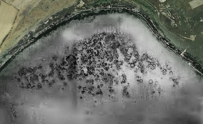
A large settlement, under the waters of the Cabras pond, in the province of Oristano, land of the Giants of Mont'e Prama.
In terms of geometries and dimensions, the submerged structures seem compatible with those of Nuragic architecture.
Behind this, which appears to be a hypothesis to be validated from an archaeological-scientific point of view, there is the work of a landscape architect from Cabras, Giuseppe Sanna, 31 years old.
His study, published in the latest issue of the Class A scientific journal "Restauro Archeologico", published by "Firenze University Press", focuses on the visual connections of the nuraghi in the Sinis peninsula.
These connections - which also allowed the architect to survey five new nuraghi - all point to the area of Conca Illonis, a prehistoric settlement, at the south-west corner of the pond.
"I chose to summarize the visual connections by following the cardinal axes east-west, from the sea to the pond and north to south, from the southern tip of Capo San Marco to the MontePrama site", explains Sanna.
It will also be important to establish the dating of the buildings of the settlement that the Sardinian scholar identified through digital tools such as the Geographic information system and aerial photos through software.
"A study that brings interesting data and raises questions, but which necessarily must be verified with archaeological investigation. The image seems to reflect typical elements of the Nuragic villages of the 14-13th century BC, therefore the recent and final Bronze Age", he observes the archaeologist Momo Zucca.
"Studies always constitute a point of support for future research and requests - underlines Giorgio Murru, head of the educational research area of the Mont 'ePrama Foundation - the architect Giuseppe Sanna has carried out worthy work. These are hypotheses that must be supported and confirmed by an archaeological-scientific research. The Mont'e Prama Foundation, in recent months, presented a prospecting project for the pond, the result of synergy with the Universities of Sassari and Salento. Next autumn we will start a series of reconnaissances in the lagoon to find out and understand what they hold these waters."
For the mayor of Cabras Andrea Abis it is "an exceptional study done by a young man from the town. This large-scale reading certainly needs a campaign of excavations and targeted research".
Reproduction reserved © Copyright ANSA