
Let the seasonal depressions rest assured, March 20 is approaching, spring is back.
“[He] should make us understand once and for all that nothing is ever lost,”
wrote Sylvain Tesson, to chase away the last clouds of winter.
Above all, it should be accompanied by milder weather, which invites you to enjoy the great outdoors.
Our selection of six hikes (find our complete guide here) across the four corners of France offers the most diverse landscapes to enjoy, with family or friends, the days that lengthen and the trees that bud.
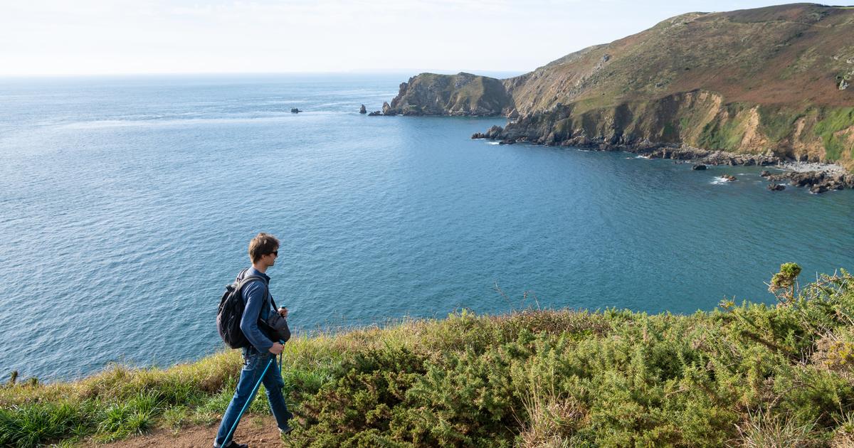
The cliffs of La Hague, in the English Channel
La Hague is the end of the Cotentin peninsula, located northwest of the English Channel.
david hughes - stock.adobe.com
The GR 223 of La Manche offers 450 kilometers of hiking between paths on the side of cliffs, bocage paths, or even trails along large sandy beaches.
On this “Sentier du littoral”, which extends from the Bay of the Seine in the east to Mont Saint-Michel in the west, the most beautiful and impressive route is undoubtedly the one which connects the lighthouse from Goury to Vauville.
We are in the heart of the wild Landes and the cliffs of La Hague.
For some, already a little at the end of the world.
With a distance of only 16 kilometers, it takes five hours to cover it.
As long as you don't stop every five minutes to admire the views!
Experienced walkers will understand: the “positive elevation gain” of this stage is 700 meters.
A small health break is possible halfway along the Nez de Jobourg.
The tour of Belle-Île
The Pointe des Poulains.
The largest island in Brittany, Belle-Île-en-Mer (Morbihan) sometimes has demanding terrain.
DalaiLahm
Belle-Île-en-Mer can also be experienced on the hiking side.
The GR 340 (variant of the GR 34) which criss-crosses the largest of Brittany's islands was indeed elected the French people's favorite long-distance hiking trail (GR) at the end of 2021, succeeding that of Pays Grand Pic Saint-Loup.
The French obviously like to wander along the blue waves: this is the third time that a coastal path has obtained this title, after the Breton GR 34 in 2017 and the Norman GR 21 in 2019.
87 kilometers long, the tour of the island of Morbihan can be completed in a maximum of five days at a leisurely pace, in four days for the more sporty.
It can be done, as desired, clockwise or counterclockwise.
Here are our tips for doing the tour in five steps.
Lake Causse, in Corrèze
Nestled in a green setting, the site has become the Brivistes seaside resort, the ideal place to cool off, spread out your towel or take a paddle tour.
capude1957 - stock.adobe.com
Between Périgord Noir, Brive basin and lower Dordogne valley, the verdant Corrèze causse may well be the geological continuation of the Quercy causses, but it hardly resembles them.
This is demonstrated by the 100 hectares of Lake Causse.
Nestled in a green setting, the site has become the Brivistes seaside resort, the ideal place to cool off, spread out your towel or take a paddle tour.
A family hike, without any difficulty, goes around it in a little over an hour along the “
circum lacustrine
”, a 7-kilometer stone path.
On the route, the Lissac mill which turned its millstones since the 18th century now houses the Water and Fishing House.
Other slightly more demanding hikes leave all around to discover the large Couzage forest or the Fournet plateau dotted with dolmens and chabanas, these dry stone shelters.
The shepherds came there to shelter from the downpours, store tools and sometimes, it is said, to lull a shepherd...
In practice
Tour of Lake Causse.
Easy > 1h15 > 7 km > elevation: + 25 m/-25 m > GPS point: 31T 379199.714 / 4994714.670
Departure: from the Maison de l’eau et de la peche car park
Map IGN 2135 SB Brive-la-Gaillarde
Around Cordes-sur-Ciel, in the Tarn
800 years of history perched on a promontory and sometimes floating in a lake of clouds: welcome to Cordes-sur-Ciel, nicknamed the city of 100 warheads.
Bernard GIRARDIN - stock.adobe.com
Cordes-sur-Ciel celebrated its 800th anniversary in 2022. Elected the French's favorite village in 2014, designated Grand Site Occitanie for the richness of its heritage, the medieval city of Occitanie, perched on its promontory, can be enjoyed on foot along the its steep alleys.
This hike also allows you to get away from it and go around it to better contemplate it.
In practice
Average > 16 km > 5h40 > +200 m/-200 m > Yellow markings + “heritage trails” signs > GPS point: 31T 416520.740 / 4879356.839
IGN map n° 2241SB - Albi / Cordes-sur-Ciel
Departure: from Place Jeanne Ramel-Cals at the foot of Cordes-sur-Ciel, 25 km northwest of Albi via the D600.
Description: TopoGuide FFRP Le Tarn...on foot, ref.
D081, 54 circuits (2019).
LISTEN TO -
Advice from a mountain specialist for your first hike
Between Niolon and Redonne, on the Côte Bleue
The Calanque de l'Érevine, with its large white pebbles which stand out against the cyan-colored water.
D. MARKET / Provence Tourism
Are the Calanques of Marseille assailed by hikers?
Heading for the Blue Coast!
Among other favorites, Niolon is a small cove with a port where a few clusters of houses and fish restaurants popular with the Marseillais nestle.
The path runs along the railway line for a few hundred meters before becoming a roller coaster above the water.
We wander among the cistus, broom and Kermes oaks to the irresistible Érevine beach with its large white pebbles clattering on cyan-colored water.
Further on, the landscape changes: the rock becomes ocher and the tortured pine trees exude a bit of mystery.
Here we are in Méjean, a small inhabited port dominated by the large arches of a viaduct.
The walk ends at La Redonne, in the next cove with emerald waters.
In practice
8 km.
Easy level (avoid taking young children given the verticality of certain passages).
Low elevation.
Route between two stations.
IGN map: 3145 ET Marseille/Les Calanques.
Occi, to rediscover the Corsica of yesteryear
The very last resident of Occi, Félix Giudicelli, died there in 1918. Denis Derond
The Isle of Beauty has around a hundred of these deserted places, whose ruins bear witness to an ancient history.
These villages live today according to pilgrimages or the passage of hikers.
The abandoned one of Occi is located above Lumio, in Balagne, nestled on a plateau at an altitude of 377 meters offering a breathtaking panoramic view.
In practice
Three paths lead to the village.
- The first is located a few meters above the entrance to the Panoramic campsite, on departmental road 71 which connects Lumio to Lavatoggio but its maintenance is not regular.
The path is partly paved and climbs gently.
- The second, the longest and most difficult, begins at the Notre Dame de la Stella chapel between Capu d'Occi and Capu Braccaghju.
- Finally, the third starts from the hotel-restaurant A Casa di Mà at the northern entrance to Lumio, it is the best maintained and the most used.
Duration: 20 to 30 minutes of walking are on average necessary to reach Occi.
Whatever path you choose, this walk is accessible with children
ON VIDEO -
In the footsteps of a hiking trail marker