
In old Provençal, “calanco” is both a steep alley, a steep path, and by extension, these serpentine cuts dug into the limestone by stubborn rivers when the sea was 120 m lower.
The mountain range between Marseille and Cassis has no less than 26 over around twenty kilometers.
A real infiltration operation from the sea towards the land.
A world apart, fierce, hostile and at the same time devastatingly beautiful.
To discover
Stays in France: weekends, hotels and tailor-made stays from our partners
Behind its apparent harshness, this coastline remains fragile and has long suffered from its proximity to France's second city.
Before the overcrowding linked to leisure activities and the quotas which return in good weather, the creeks experienced the eradication of their white oak forests cut into marine timber, the exploitation of their limestone in predatory quarries, then the blossoming hundreds of lime kilns and small chemical industries...
Since 2012, a national park, both terrestrial and marine - respectively 8,500 ha and 43,500 ha in the heart of the park - has attempted to preserve the environment from the urban pressure exerted by Marseille.
Every year, nearly 3 million visitors venture inside the park on foot or by boat.
Only a very small part of them embark on the complete crossing of the massif from Marseille to Cassis, which normally takes two or three days.
This hike between the Calanque de Sugiton and Callelongue explores the most spectacular corners of the park and can be done in a day using only public transport.
As access to the Sugiton cove is now regulated, it is better to consider it out of season.
Tips for hiking in the creeks
It is best not to take this crossing lightly.
Bring suitable equipment: walking shoes, backpack, sunscreen, hat or cap, at least 2 liters of water and energy bars.
It is also better to have a map at 1:25,000. From June 1 to September 30, access to the forest areas of Bouches-du-Rhône is regulated to reduce the risk of fire.
These are communicated every day for the next day, between 5 p.m. and 6 p.m. by the prefectural services (bouches-du-rhone.gouv.fr).
Download the Mes Calanques application before the visit for real-time information and to be notified of any closures of the National Park.
From Sugiton to Callelongue,
hiking in practice
Descent towards the Sormiou cove.
Christophe Migeon / le Figaro
Difficult
> 17 km > 6h30 > + 950 m /- 950 m.
IGN TOP 25
map n°3145ET - Marseille - the creeks
Departure:
From the barrier in front of the Marseille-Mediterranean School of Art and Design (ESADMM) located in the Luminy area.
Access from the Rond Point du Prado metro station then bus no. 21 to the Luminy terminus.
To return from Callelongue, take bus number 20 to La Madrague then number 19 to return to the Rond Point du Prado metro station.
Description: TopoGuide Ref P132 The creeks...on foot.
Departure from Sugiton
Between Sugiton and Morgiou.
Christophe Migeon / le Figaro
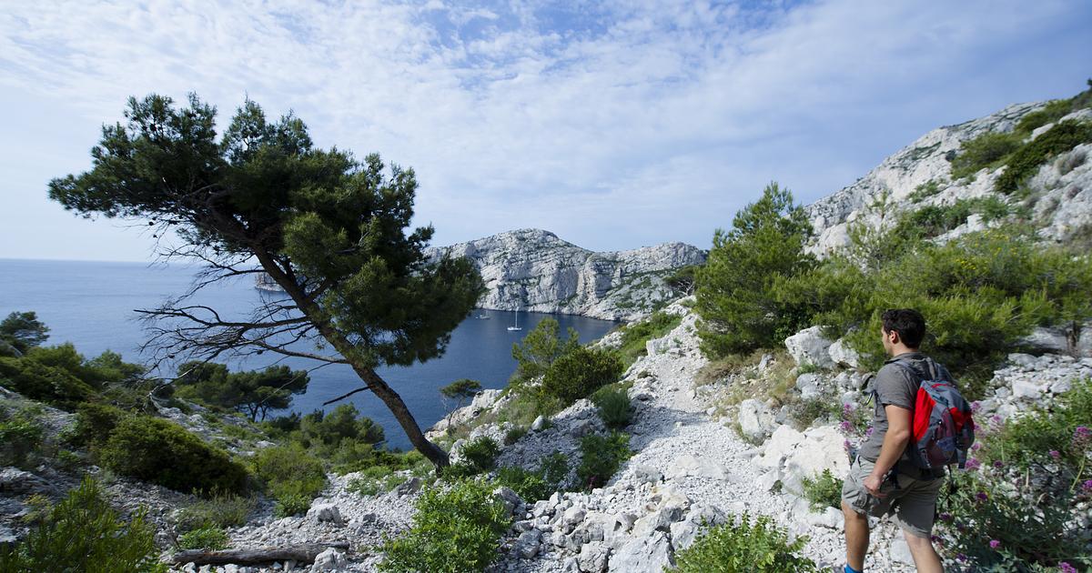
From Luminy, a false flat - very false - leads to the Sugiton pass in the shade of the maritime pines.
Remains of sheepfolds remind us that before being a university campus, the Luminy estate has long given pride of place to livestock and crops: cereals (wheat, oats), fruit trees (olive trees, almond trees, mulberries, fig trees, cherry trees) and vines since at least the 15th century.
It seems that in the 1960s, wild goats were still encountered there.
The Sugiton cove, towards which we flow along a narrows cluttered with suicidal Aleppo pines, is the perfect example of this concentration of rocky and coastal Mediterranean saturated in white and blue.
On one side the geologists' Urgonian limestone.
On the other, the aquamarine ink of poets.
Fragrances of rock browned by the sun mingle with the scents of scrubland salted by the sea spray.
With rainfall in trickles, unrewarding soil that retains nothing and a mistral that dries out what little could have been retained, the vegetation is not happy.
But when you are not a thirsty juniper or a dehydrated partridge, and the water bottles in your backpack are full and still fresh, then these cliffs become a real little paradise.
To listen -
Advice from a mountain specialist for your first hike
LISTEN TO OUR PODCAST
Steps
FROM SUGITON TO SORMIOU
Sormiou.
Christophe Migeon / le Figaro
A crossing of the creeks can only be considered with good shoes and plenty of water.
It is better to avoid flip-flops when negotiating the path that goes down to Morgiou.
That said, Louis XIII was undoubtedly in heels when, in November 1622, he took the stairs leading to the beach.
The latter was cut into the rock by local fishermen so that His Highness could try his hand at harpoon fishing – a silver-gilt trident please – in a trap.
A team of rock climbers plays spiders along a cliff.
The creeks, where the young Marseillais Gaston Rebuffat came to work his catches in the 1930s, are equipped with nearly 1,200 climbing routes.
Offshore, the flotilla made up of Riou, Ile Plane and Grand Conglué, seems ready to drift away at the first gust of wind.
In the abundance of squawking and squawking gulls, we look out in vain for the rare Cory's Shearwaters and Storm-petrels which nest on the islands.
Soon the turquoise cove of Sormiou appears, a private cove, belonging to the same family since the 19th century.
FROM SORMIOU TO CALLELONGUE
The discreet Calanque des Queyrons.
Christophe Migeon / le Figaro
Between the rocks, the surface reveals the furtive shimmer of sea bream and oblades tossed by the swell above the posidonia.
Falco, faithful mate of the Calypso, put on his first fins on this beach to go hunting for octopus and sea bream.
The one that Cousteau called “the god of water” had discovered under Cape Morgiou at the exit of the cove the entrance to a long and narrow corridor at a depth of 39 m.
But it was Henri Cosquer who a few years later reached the end of the tunnel and discovered an extraordinary cavern decorated with Paleolithic paintings.
In Sormiou, after the restaurant called the Château, you must turn right on brown path no. 2 to the Sormiou pass, which is reached by a twenty-minute climb.
There, we find the GR 51 which we will follow to the end.
Past the pass, the path frolics along a succession of cliffs that are both dry and chubby like meringues coming out of the oven.
The coves follow one another, discreet, too shy to really festoon the limestone wall: Cortiou, l'Escu, Podestat, Queyrons...
In Marseilleveyre, the landscape softens, the mountain bends its back and becomes less steep as if it felt the city approaching.
Two kilometers further, we place our soles on the asphalt of Callelongue with the impression of coming back from the moon.
Travelogue
Or sleep
Villa Le Sud.
Towards Cassis, at the foot of the Calanques massif, a modern house and its four bright bedrooms with private terrace, opening onto a swimming pool.
From €230 per night.
Tel.: 06 20 74 14 56, villalesudcassis.fr
The Sardine Box.
Excellent cuisine and good atmosphere in an atypical decor.
The ideal Marseille restaurant for an iodized stopover.
Garlic and parsley squid €20, sardines €16.
2 boulevard de la Libération, 13001 Marseille.
Such.
: 04 91 50 95 95, laboiteasardine.com
The White Rocks
.
Great luxury in the creeks.
This 1887 mansion perched above the cliffs of Cassis facing Cap Canaille has welcomed guests as prestigious as Churchill and Edith Piaf.
4 rooms and 7 suites surrounded by umbrella pines with direct access to the sea. From €600 per night.
Tel.: 04 42 01 09 30, roches-blanches-cassis.com
TO DO
Dives in the creeks.
To have a baptism and discover the “creeks below”.
The Goudes Leisure Center is located in the small fishing port of Les Goudes, in the national park.
2-day weekend €215 per person.
Such.
: 04 91 25 13 16, goudes-plongee.com
Visit to the creeks by boat.
To discover the national park from the sea. Full exploration of the coves up to Cassis, €32.
Tel.: 04 91 58 50 58, cruises-marseille-calanques.com
In video -
Catching a fish in the creeks of Marseille will soon cost you a photo