
Sainte-Victoire appears in nearly a hundred works by Cézanne.
The painter was sensitive to the silhouette, the colors, the sovereignty of this mountain which scars the sky to the east of Aix-en-Provence.
Inspiring, it still is for hikers.
Depending on the starting point, it resembles a rocky wall erected above a plateau, a petrified wave cutting out the horizon or a long ridge covered in Mediterranean vegetation.
Here are our suggested routes to discover its different faces.
In the footsteps of Cézanne: Zola dam and Bibémus quarries
Very quickly, the route rises through the scrubland and the undergrowth to reach an open space watched over by the sculptural mountain.
Cintas Flores
The village of Tholonet flatters the eye with its yellow bastide flanked by a long avenue of century-old plane trees.
This is where this hike in the footsteps of Cézanne begins, as the artist explored the surrounding trails with his easel for years.
Very quickly, the route rises through the scrubland and the undergrowth to reach an open space watched over by the sculptural mountain.
We continue on a wide track to the Bimont dam, a hydraulic structure on the Canal de Provence which forms an intense blue lake where the pine forest is reflected.
Further on, the path, narrower and shaded, becomes more intimate.
Winding at the top of a valley, it offers beautiful views of the mountain.
We approach the Bibémus quarries, an ocher and mineral decoration present in several Cézanian works, before descending towards the Zola dam.
Built by the writer's father, very close to the painter, this small body of water set in the trees seems so precious that its image is taken to Tholonet.
In practice:
approximately 9 km.
Easy level, suitable for families.
Elevation gain: 400 meters.
South face, a dizzying climb in a mineral setting
The red earth that fringes the southern slopes of Sainte-Victoire sets the tone for a grandiose itinerary.
E. DAUTANT / Provence Tourism
The red earth that fringes the southern slopes of Sainte-Victoire sets the tone for a grandiose itinerary.
Higher up, beyond the scrubland, high cliffs extend from east to west for nearly 20 kilometers.
From the Deux Aiguilles car park, we walk through the scrubland to the Elephant's Pasture.
There begins a regular climb on the path cut into the rocky side of the mountain.
A few aerial passages where you have to climb (easily) or a scree allow you to experience the mountainous character of Sainte-Victoire.
The
garagaï
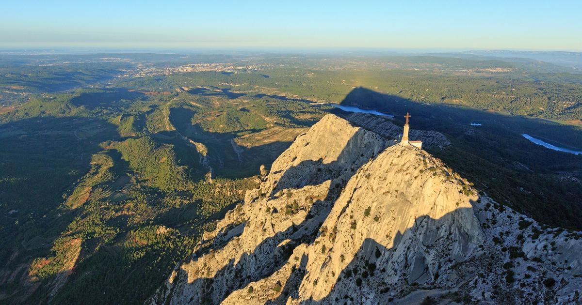
, this impressive breakthrough in the rock to cross, announces the arrival on the ridges where we quickly reach the Croix de Provence at 946 meters.
From the Écrins to the Alpilles, from Sainte-Baume to Mont Ventoux, on a clear day, you can admire the regional peaks.
The descent takes place further west, via Pas de l'Escalette, to the hamlet of Le Trou, whose ruins exude a scent of melancholy.
The path then winds around the foot of the cliffs, giving the opportunity to contemplate the stone scrolls until returning to the starting point.
In practice:
approximately 7 km.
Difficult level, avoid if you are afraid of heights.
Elevation gain: approximately 600 meters.
North face, a forest atmosphere
From the village of Vauvenargues dominated by Picasso's pot-bellied castle, the litigants' path climbs through the pine forest.
MAMP
Change of scenery on the northern slope of Sainte-Victoire, a long gentle slope covered with vegetation.
Without an escarpment, the mountain seems more modest.
From the village of Vauvenargues dominated by Picasso's pot-bellied castle, the litigants' path climbs through the pine forest and the green and white oak grove to the Col de Suberoque, on the ridges.
At the end of this pleasant, largely shaded climb, the hiker is treated to a 360° panorama of the Provençal relief.
Moment of contemplation.
On the rocky ridge which flirts with 1000 meters, we continue the path for a few kilometers towards the west.
Last stop on the ridges: the Croix de Provence and the Priory, whose origins date back to the 13th century, when a chapel here was the subject of a pilgrimage.
We return to Vauvenargues through the scrubland, via the Chemin des Venturiers, taken by the pilgrims of yesteryear.
In practice:
approximately 15 km.
Average level.
Elevation difference around 700 meters.
Pic des Mouches: the summit from Puyloubier
Vineyards frame the road before arriving at Puyloubier, a pretty Provençal village leaning against the slopes of Sainte-Victoire.
B. BECHET / Provence Tourism
Vineyards frame the road before arriving at Puyloubier, a pretty Provençal village leaning against the slopes of Sainte-Victoire.
We are at the east end of the mountain.
A short but sharp climb lifts walkers onto the mountain ridge, almost 600 meters, revealing prodigious views in all directions.
To the north, we can see the Écrins massif, snow-covered in winter.
The summit of Sainte-Victoire is not the Croix de Provence (946 meters), at the west end, as is often believed, but the Pic des Mouche (1011 meters) to the east.
Along the ridge, we walk and climb without realizing it, towards this high point with no sign visible in the distance.
Welcome, an orientation table shows the Provençal landscape which unfolds on the horizon, from Sainte-Baume to Ventoux, via the Alpilles and the Luberon.
On a clear day, the sea also enters the panorama.
Difficult to set out to go back down, but the stony path which joins the relay and vineyard of Saint Ser, near Puyloubier, crosses beautiful wild and little frequented corners.
In practice:
approximately 10 km.
Medium-difficult level.
Elevation difference: almost 700 meters.
Practical
The Sainte-Victoire mountain as well as the Concors massif, to the north, are the subject of a preservation, management and development project labeled “Grand site de France”.
C. DUTREY / Provence Tourism
Grand Site de France Concors Sainte-Victoire
The Sainte-Victoire mountain as well as the Concors massif, to the north, are the subject of a preservation, management and development project labeled “Grand site de France”.
Reception is provided throughout the year at the headquarters of the large site, southern slope: La Ferme,
66, route de Meyreuil, 13100 Beaurecueil.
Tel: 04 42 64 60 90
Open Monday to Friday, 9 a.m. to 12 p.m. and 2 p.m. to 5 p.m.
Two information points also open their doors in season in Vauvenargues (to the north) and to Saint-Marc-Jaumegarde (to the west).
Sainte-Victoire House
Departmental road 17, 13100 Saint-Antonin sur Bayon. Such. : 04 13 31 94 70.
Open Tuesday to Sunday, from 9 a.m. to 12:30 p.m. and from 1:30 p.m. to 6 p.m.
At the foot of the southern slope, this information point managed by the department offers a museum space, an exhibition room, a discovery trail and a restaurant.
Preferred periods - Access:
Avoid the summer period when high temperatures and peaks in crowds make hiking unenjoyable.
In addition, from June 1 to September 30, access to the forest is regulated due to fire risks.
Find out the day before, from 6 p.m., on the internet or on 0811 20 13 13 to check that access is authorized.
Some trails may also be temporarily closed during the reproduction period of sensitive species.
The information is available on the main site's website.
Maps and topoguide
IGN 82017 Montagne Sainte-Victoire maps, from the “Discovery of exceptional places” collection, more precise than classic IGN maps.
Topo guide The Sainte Victoire mountain, 5th edition, April 2019.