Icon: enlarge
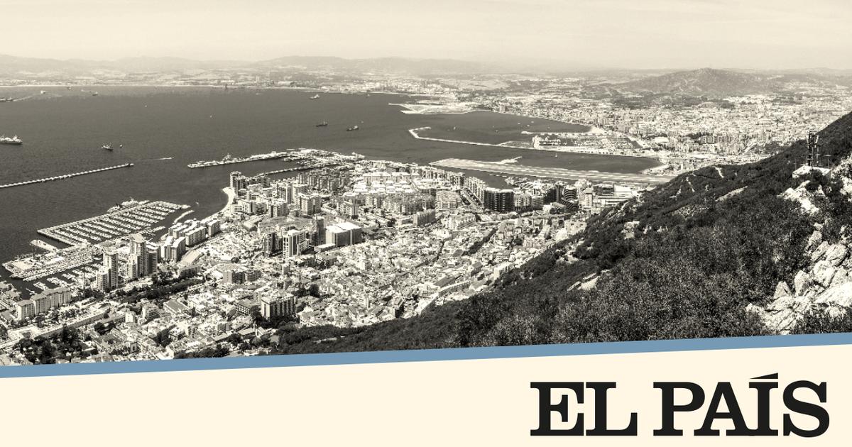
False color image of the Strait of Gibraltar
Photo: Copernicus Sentinel Data / ESA
It's not even 14 kilometers that separate Europe from Africa.
The short distance separates the two continents, which were most recently mentioned in connection with refugee movements.
Nowhere can this conflict be portrayed more graphically than on the Strait of Gibraltar.
The place that connects the Mediterranean and the Atlantic is a symbol of migration - and people keep dying here.
The number of those who want to leave their homeland has increased in Africa in recent years.
According to UN refugee aid, there were around 6.3 million at the end of 2019.
However, only some of these people make it to Europe, many stay in their home region or visit neighboring countries.
According to estimates by Europe's border protection agency Frontex, the number of people reaching the European Union has recently declined.
Few take the risky route across the western Mediterranean.
Most of the people who come by sea make the passage in the eastern Mediterranean.
The numbers have also declined in the central Mediterranean region.
But people still perish trying to reach mainland Europe.
This year alone the number of known victims is well over 200 - the number of unreported cases is likely to be considerably higher, because many are not found and sink forever into the depths of the sea.
In the satellite image above, Spain and Morocco are facing each other.
The narrowest point of the 58 km long canal is between Point Marroquí in Spain and Point Cires in Morocco.
Several prominent cities are shown in gray in the picture.
This includes the port city of Tangier, which is only 27 kilometers from the southern tip of Spain.
At the southern end of the Iberian Peninsula, the large Bay of Gibraltar with the city of the same name in the east and the opposite municipality of Algeciras can be seen.
The picture was taken by the "Sentinel-2" satellites of the European Space Agency ESA on October 28, 2020.
However, it is not a photograph, but a false color image.
The picture shows the electromagnetic spectrum in the infrared range.
Such images are often used by environmental researchers to assess plant density, since plants reflect near-infrared and green light while absorbing red light.
Regions overgrown by plants appear in bright red, making them easier to see.
Icon: enlarge
A three-dimensional perspective of the Strait of Gibraltar reveals the ridges on the coast
Photo: JPL / NIMA / NASA
On the other hand, waters such as the Mediterranean and the Atlantic are shown in dark blue or black.
Cloudy water, as can be seen along the Spanish coast at the top left in the picture, appears in cyan to light blue.
Presumably this is due to sedimentary water that flows from rivers into the sea.
Even if the distance between Spain and Morocco seems short, there are always deaths when crossing the strait.
There is a strong current here and there are strong winds that drive the waves.
The often overloaded and unsuitable boats capsize and tear people to their deaths.
The bodies are sometimes washed up on Spanish beaches.
Nobody knows exactly how many people die here.
It is estimated that the number is three times as high as that of those washed ashore.
A sad result for the Strait of Gibraltar.
Icon: The mirror
joe


/cloudfront-eu-central-1.images.arcpublishing.com/prisa/HSW65BJETBHZNOZNHZDBJSXFMM.jpg)