A weather situation conducive to thunderstorms developed between Tuesday September 14 and Thursday September 16, mainly affecting the southern and central parts of the country.
On the Gulf of Lion, the south-easterly wind blows a mass of humid air towards the Cévennes where sustained rains occur, said
La Chaîne Météo
.
Read also Weather: five departments on orange alert for risk of thunderstorms
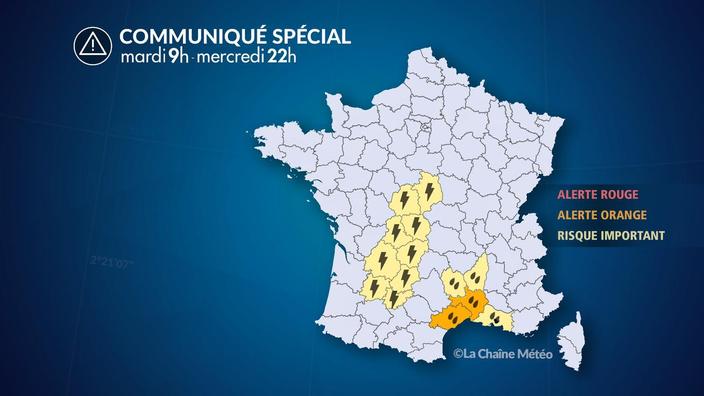
The
Gard
and the
Hérault
are placed in orange vigilance for the risk of thunderstorms, following a very unstable southerly flow.
Heavy stormy rains go up from the Mediterranean towards Languedoc and the Cévennes which suffer from occasional intense rains in a short time.
Thus, between 7 and 8:30 am 107 mm of rain fell in Vacquières (34), 42 mm in Moulès-et-Baucels (34), 40 mm in La Grand Combe (30), 30 mm in Saint Hippolyte-du-Fort (30), the equivalent of 2 weeks to 1 month of precipitation in the municipalities mentioned.
During the night from Tuesday to Wednesday, thunderstorms will continue to circulate from the southwest to the central regions, where they will be sometimes heavy.
The departments affected by thunderstorms and heavy rains Screenshot The Weather Channel
* The Weather Channel belongs to the Figaro group.