
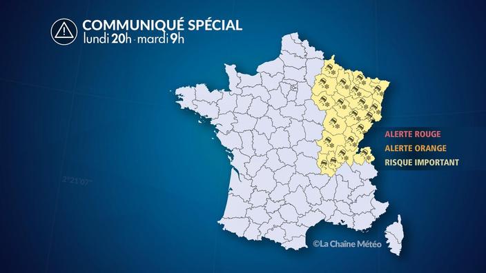
The extreme cold is pointing the tip of its nose in the north-east of France, announces The Weather Channel * in its latest bulletin, dated Monday, November 30.
The Grand Est, Bourgogne-Franche-Comté and northern Auvergne-Rhône-Alpes will be particularly exposed from this Monday evening to low-altitude snowfall and black ice until Tuesday 9am.
Read also: Climate: excessive taxes and aid with limited results
The Grand Est will be the first affected region, from 8 p.m.
During the night from Monday to Tuesday, the disturbance will slide southwards: Lorraine, Alsace and Burgundy will be affected by significant snowfall.
From an altitude of 400 meters, a small layer of snow of 2 to 4 cm should temporarily cover the ground.
Above 600 meters, the layer will reach up to 10 to 15 cm on the Vosges.
Tuesday, the disturbance will reach Burgundy-Franche-Comté and Auvergne-Rhône-Alpes.
Snow and rain risk causing slippery phenomena with a general ice storm between the south of Burgundy-Franche-Comté, the Val de Saône and the north of the Rhône-Alpes due to a very cold night, warns the Weather Channel .
Fogs will be frequent, sometimes dense and freezing.
Read also: The heckled landing of the Citizen's Climate Convention
In detail, the departments placed at "
significant risk
" by the Weather Channel are Ain, Ardennes, Aube, Côte-d'Or, Doubs, Jura, Loire, Marne, Haute- Marne, Meurthe-et-Moselle, Meuse, Moselle, Bas-Rhin, Haut-Rhin, Rhône, Haute-Saône, Saône-et-Loire, Haute-Savoie, Vosges and Territory from Belfort.
From 9 a.m. on Tuesday, rising temperatures should melt the ice.
The snow will then only hold up in mountains above 500 meters above sea level.
* The Weather Channel is owned by the Figaro group.