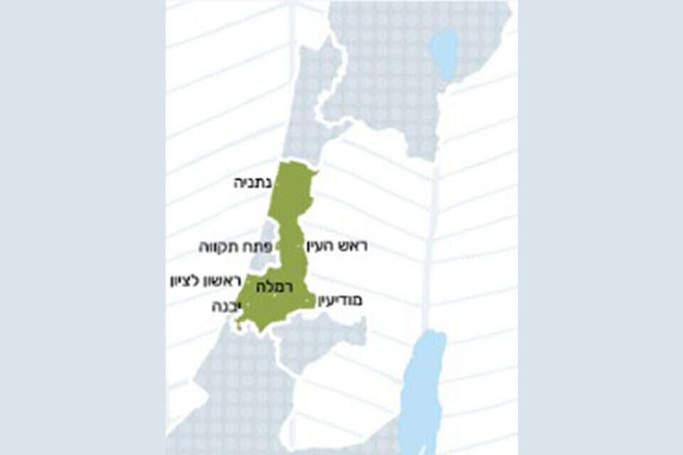
A map without the territories of Judea and Samaria was presented on an official website of the State of Israel, specifically in the body for which Interior Minister Ayelet Shaked is responsible.
The website of the Planning Director, who is responsible for planning projects throughout the country, including infrastructure and housing, regulation and licensing in construction and preparation of regulations and strategic plans - until recently presented for many days a map with a division of the State of Israel by regions.
Judea and Samaria area - painted white, just as the Mediterranean Sea is shown, as if it does not exist.
Following the request of "Israel Today", the map that the apartment was a large part of the State of Israel was removed.
Engineers who recently visited the Planning Director's website were shocked to discover that the home page of the district planning committees, including Judea and Samaria, shows a map that does not include Judea and Samaria. When you put a map without Judea and Samaria you say something. That's a statement. So when it comes to the planning director - there is a grave concern that political reasons are behind the decision. ".
B'Tselem turned to the chairman of the planning directorate, Dalit Zilber, this week, with copies to the prime minister, Naftali Bennett and the interior minister, and received information about how the map was presented. In presentations and maps, "wrote the organization's CEO, Shai Glick, in his complaint.
"Until recently, the Judea and Samaria District was marked on the website of the Planning Director behind a dividing line, as a part associated with the State of Israel but separated.
There has been a further deterioration recently.
The site has been updated graphically, and now you have completely missed Judea and Samaria. "
Glick added: "It is puzzling that this district does not get a map, as it is determined and has a distinct geographical definition and boundaries. Maps and plans of the Planning Director, in addition to the existing situation, also present the state's vision. "Another of the State of Israel, which is appropriate to impart an extreme political vision and constitutes a violation of the service provided by the planning director. We demand the return and inclusion of the Judea and Samaria district within the boundaries of the graphic maps presented by the planning director."
Following the inquiries of "Israel Today" and "B'Tselem", the problematic map was removed from the site and now in its place there is a reference to the various districts.
The Planning Directorate stated: "The Planning and Building Law does not apply in Judea and Samaria, and the map refers to places where the Planning Director and the planning institutions have powers.
It is important to note that in programs where there is an interface with Judea and Samaria, "planning takes this into account."
Interior Minister Ayelet Shaked's office said: "The interior minister is not ready for such maps under her office and she demanded to change them all. That is the map, but the interior minister demanded that it be changed. "
Were we wrong?
Fixed!
If you found an error in the article, we would love for you to share it with us