The impressive images left by Hurricane Ian 1:58
(CNN) --
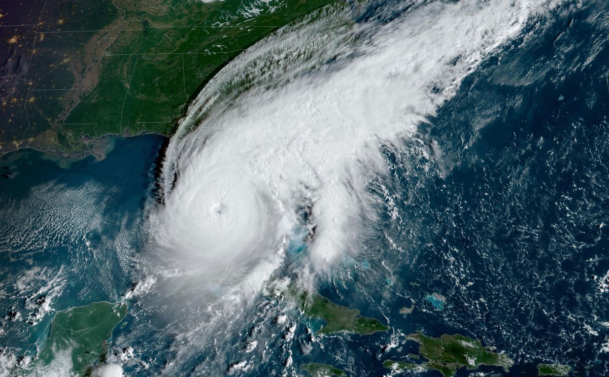
Hurricane Ian made landfall along Florida's southwest coast near Key Costa around 3:05 p.m. (Miami time) with winds near 150 mph (240 km/h), which made Ian a top-tier Category 4 hurricane.
Whatever happens from now on, this is going to be a major hurricane hitting the western coast of Florida.
Tropical-storm-force winds are likely to be felt across the Florida panhandle as the storm makes its way across the state Wednesday through Thursday before moving off the eastern seaboard.
Hurricane Ian Breaking Live: Track, News, and Florida Landfall
Among the risks is the wind, which will be extremely dangerous and is what most people think of when they think of hurricanes.
But there is also the storm surge.
The Florida Keys were already hit overnight with storm surge.
Therefore, we know that Ian is capable of producing a dangerous tide.
The National Hurricane Center said the highest storm surge risk will be from Naples to the Sarasota area.
Englewood to Bonita Beach, Port Charlotte, Punta Gorda, as well as Cape Coral and Fort Myers could see a "catastrophic storm surge" of 12 to 18 feet (3.6 to 5.4 meters).
Hurricane Ian could be an unprecedented tropical cyclone in Florida.
We explain why
Don't let your guard down if you don't live near the coast
One of the most widespread concerns is that of extreme rainfall.
This will extend from Ian making landfall in the Carolinas.
advertising
The map shows the areas where extreme rainfall is expected from Hurricane Ian.
"Widespread, life-threatening, catastrophic flooding is expected in portions of central Florida, with significant flooding in southern Florida, northern Florida, southeastern Georgia and coastal South Carolina," the hurricane center said.
"Significant and prolonged river flooding is expected throughout central Florida.
The Weather Prediction Center issued its highest forecast for extreme precipitation, level 4 out of 4.
Hurricane Ian could be an unprecedented tropical cyclone in Florida.
We explain why
Rainfall will likely exceed 3 inches (76 mm) per hour today and will result in at least 1 foot (30 cm) of rain across central Florida, the center said.
And that's just the estimate for this Wednesday.
It does not include Thursday, when more rain could fall over the same areas.
There is also a risk of tornadoes
"Several tornadoes will be possible across the Florida panhandle today, in association with Hurricane Ian," the forecast center said.
The map shows the risk of tornadoes in Florida after the arrival of Hurricane Ian.
Tornadoes are often associated with hurricanes and tropical storms and can occur hundreds of miles from the center of the hurricane.
Tornadoes in tropical systems tend to be short-lived and difficult to predict, with much less lead time compared to tornadoes produced by supercells and strong thunderstorms in the central and southern plains.
The most likely area for tornado development will be along the Space Coast and inland toward Orlando.
What to expect from Hurricane Ian in Tampa, Fort Myers, Punta Gorda and more
Finally, there is an unusual risk that has caused us to double check our forecasts.
Hurricane Ian will bring strong northerly winds across much of the Southeast.
This, combined with relatively dry air to the South, has prompted the Storm Prediction Center to issue a critical level 2 of 3 fire forecast for parts of the region from Louisiana to Florida.
The forecast includes cities like New Orleans, Mobile, Alabama and Tallahassee, Florida.
This risk only means that, if a wildfire starts, the conditions would be right for it to spread.
Hurricane Ian