Marshall Islands: History, Politics, Population and Geography
Created: 04/01/2022 13:03
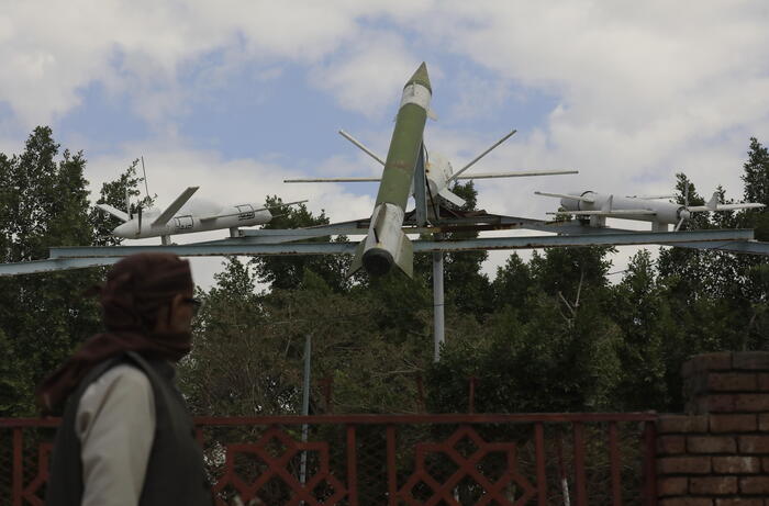
Bunkers for observing the atomic bomb test, Marshall Islands, Bikini Atoll © IMAGO / OceanPhoto
At first glance, the Marshall Islands appear like a holiday paradise.
However, the archipelago looks back on a sad past.
They were used for nuclear weapons tests, the consequential damage of which continues to have an impact today.
The Marshall Islands belonged to the German Empire during the colonial period.
The Bikini Atoll gained notoriety from the US atomic bomb tests.
The local population today suffers from the so-called civilization diseases such as obesity.
Majuro - Covering a land area of 181.4 square kilometers, the Marshall Islands are an island country in Oceania.
Not only in terms of area, but also with a population of 53,000 people, they are among the smallest countries in the world.
The island paradise achieved notoriety through nuclear weapons tests, which the USA undertook on some atolls in the 1950s.
Many atolls and islands are now threatened by rising sea levels.
Marshall Islands: European discovery and German New Guinea
Little is known about the early history of the Marshall Islands.
It is assumed that they were probably settled from Micronesia in the 2nd millennium BC.
In 1526 the Spanish explorer Alonso de Salazar reached the islands.
Nevertheless, Spain made no claims.
The islands remained largely unnoticed for two centuries until English Captain John Marshall arrived here in 1788 and recorded their location.
The islands were later named after him.
Another mapping took place at the beginning of the 19th century by the German-Baltic explorer Otto von Kotzebue.
Missionaries established the first schools in the Marshall Islands in the mid-19th century.
Finally, a trading post of the German Reich was established here.
German merchants planted coconut plantations here for the purpose of extracting copra.
In 1885 the German flag was hoisted on the island of Januit as a sign of possession and the German Empire took over sovereign rights in 1886.
20 years later the islands officially became part of the German New Guinea colony.
Marshall Islands: Japanese and American occupation
At the beginning of the First World War, the Japanese occupied the Marshall Islands after declaring war on the German Reich.
They immediately set up military bases there and took over the management.
After the end of the war, Japan was entrusted with the mandate of the island administration by the League of Nations.
This almost completely isolated the islands from the rest of the world and Japan began to settle Japanese immigrants and disenfranchise the local population.
During World War II, the Marshall Islands again became important military bases for Japan.
However, the Japanese troops could not withstand the US military offensive of 1944 on Kwajalein Atoll.
As a result, American forces occupied numerous other islands and used aerial and naval bombardment to ensure that Japan's troops were held down on some of the remaining islands.
After the war, the US demanded that the UN hand over the Marshall Islands to them as part of the United Nations Trust Territory.
Marshall Islands: Atomic Bomb Tests and Road to Self-Reliance
After part of the local population had been resettled, the Americans launched numerous nuclear and hydrogen bomb tests in the remote regions from 1946 to 1958 - including on the famous Bikini Atoll.
This caused massive damage to flora and fauna.
To this day, the former residents cannot return to their home islands, which are still highly radioactive.
Efforts were made to bring the Marshall Islands independence as early as the 1960s.
The islands took a first step formally as a republic in 1979. However, independence was only confirmed in 1986 by an association agreement with the USA, in which the American military presence in the country was still guaranteed.
The Marshall Islands only achieved full independence in 1990, after the United Nations' trusteeship to the United States officially expired.
Marshall Islands: The Political System
The Marshall Islands have been a republic since May 1, 1979, the constitution of which was last amended in 1990.
The political system consists of a parliament with 33 MPs and the "Council of Tribal Leaders" ("Council of Iroij") with twelve members, which deals primarily with customs and traditions of the country.
Parliament, in turn, has the power to legislate, since there are no states and provinces.
However, the 24 inhabited islands have their own administration.
The President is elected by Parliament.
However, he also has the option of dissolving parliament and calling new elections as soon as no confidence has been expressed in the cabinet twice in a row.
David Kabua has been President of the Marshall Islands since January 2020.
Marshall Islands: Facts at a Glance
Capital: Majuro
Official language: Marshallese and English
Area: 181.42 square kilometers
Population: 59,000 (as of 2019)
Currency: US Dollar (USD)
Administrative division: 24 municipalities
Religion: 90% Protestant, 8.5% Roman Catholic
Marshall Islands: Languages and Population
The official languages are English and Marshallese with the two dialects Ralik and Ratak.
About 92 percent of the population are Marshallese.
Just under six percent have mixed roots and a further two percent are of other descent.
The average life expectancy of the population is around 73.4 years and the population growth is around 1.55 percent per year.
Notably, however, the country has one of the highest rates of obesity.
In 2016, it was determined that almost 53 percent of the population was obese.
There were several reasons for this: The islanders had become dependent on food imports from the USA.
Since the population no longer wanted to go fishing and high unemployment set in, this led to a change in the original way of life of the inhabitants.
Marshall Islands: Geography and Cities
The Marshall Islands consist of two chains of islands and atolls that run almost parallel to each other.
These include the Ratak chain (also called the Sunrise Islands) with its 14 atolls and two islands in the east and the Ralik chain (also called the Sunset Islands), which has 15 atolls and three islands in the west.
The land area of 181 square kilometers is just two meters above sea level.
The island chains also include around 1,225 larger and smaller islands and 870 reefs, covering an area of almost two million square kilometers in the central Pacific.
The islands of Majuro Atoll and Ebeye in Kwajalein Atoll are home to two-thirds of the population.
The remaining islands are only sparsely populated or partially uninhabited.
The largest agglomeration in the Marshall Islands is Delap-Uliga-Darrit.
Around half of the population is concentrated in the capital region of the country.
The largest places in the Marshall Islands at a glance
1
Majuro: 20,144 inhabitants, Delap-Uliga-Darrit region
2
Ebeye: 9,581 inhabitants, Kwajalein region
3
Laura: 2,905 inhabitants, Majuro region
4
Ajeltake: Population 1,972, Majuro region
5
Wotje: 915 inhabitants, Wotje region
6
Eniwetok: 902 inhabitants, Eniwetok region
7
Kili: 900 inhabitants, Kili region
8
Enubir: Population 708, Kwajalein Region
9
Namorik: 670 inhabitants, Namorik region
10
Jabwor: 503 inhabitants, Jaluit region
Marshall Islands: Interesting facts about the country
The Marshall Islands are struggling with environmental problems in several ways.
After the atomic bomb tests ended, the test areas (such as Bikini Atoll or Eniwetok) were declared habitable again by the USA in 1966.
However, these had to be evacuated again in the 1970s because the radiation exposure determined was much too high.
The journalist Giff Johnson and the health activist Darlene Keju drew attention to the health consequences worldwide.
Among other things, the radiation exposure had also resulted in numerous stillbirths and birth defects in newborns.
Finally, in 2014, the Marshalls filed a lawsuit against the nuclear powers.
It is expected that the contaminated area will only gradually become habitable again over the next twenty years.
A race against time: Because of climate change, the islands are also existentially threatened by rising sea levels and an increase in extreme weather events.
Experts are now prophesying an imminent demise of the islands within the next 50 years.
The drinking water supply on the Marshall Islands has deteriorated due to periods of drought and wells that have become too salty.