
Google Maps is preparing to make a qualitative leap in its guidance services this year.
If you already indicated us with some reliability in our movements through the streets or roads, either on foot or motorized, now you will add the possibility of resorting to your help also in closed environments.
At the moment, this option is being tested in airports, transport interchanges and shopping centers in some cities in the United States (Chicago, Long Island, Los Angeles, Newark, San Francisco, San José and Seattle).
The intention of the company is to implement the service "in the coming months" in Tokyo and Zurich and, later, in other cities.
This was stated yesterday by the vice president of product for Google Maps, Dane Glasgow, in a virtual meeting with journalists.
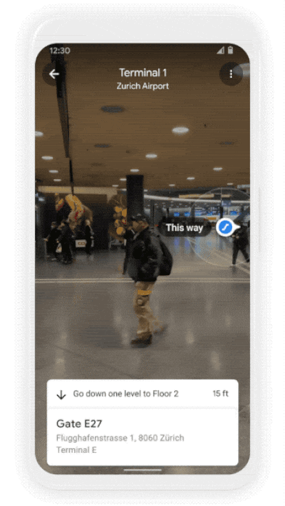
Directions to a boarding gate or the correct exit of the subway will be offered through augmented reality, a technology that has already been used outdoors: when we focus forward with the phone, as if we were recording a video, the application will integrate into the image elements as beacons that will give us the navigation instructions.
The precision of the interior maps will be such, they promise from Google, that the Indoor Live View system (thus they have baptized the tool) will be able to tell us, for example, where the closest ATM is or what route we have to do through the terminal to get to our baggage claim belt.
Example of how directions for routes inside buildings are displayed on a mobile phone at Zurich International Airport.
Augmented reality allows us to integrate beacons into the environment we focus on.
Camera always on
The Indoor Live View system is based on a new positioning technology developed by the company called global location.
This tool uses artificial intelligence to scan tens of billions of Street View images and find out where the user is going.
How?
With the incorporation of a new sensor: the mobile camera.
Until now, the GPS was solely responsible for locating us on the map.
That could leave a few seconds of doubt, without knowing for example if when leaving the subway car we have to go right or left to follow the directions on Google Maps.
With the help of the camera, the Google Maps algorithm will instantly recognize where we are, so that thanks to the image processing system it can quickly indicate where to go.
As we progress in our journey, augmented reality indications will appear, for which it is also necessary that the camera is operational.
"Thanks to new advances that allow us to know precisely the altitude and position of objects within a building, we can bring Live View to some of the interiors where it is more difficult to find your way", they point out from the company.
For Indoor Live View to work, it is necessary to photograph the buildings to be navigated from end to end, as has already been done –and is being done– with the streets of half the world for the Street View service.
That process is underway: "Thousands of buildings have already been scanned," said Russell Dicker, Google's product manager, during the media meeting.
The most ecological route
Google Maps will incorporate more news this year apart from indoor navigation.
Among them, the option of choosing the most environmentally friendly route stands out.
If the estimated time of arrival at the destination is the same, Google will choose by default the route with the lowest carbon footprint;
If the ecological route is longer, the user will be marked with the fastest and most ecological option for them to choose.
Other information that will be offered is the air quality of the destination, as well as the expected weather conditions for the time of arrival.
Drivers using Google Maps will also be alerted when they are going to pass through a low-emission zone (such as those in the center of Amsterdam, London or Madrid) so that they know if their car can enter it.
The application's driving mode incorporates new voice commands, such as sending and receiving calls or text messages without leaving the browser.
You can follow EL PAÍS TECNOLOGÍA on
and
.