
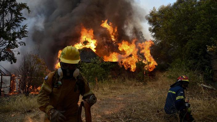
Greece was on Tuesday August 3 in the grip of new forest fires, especially north of Athens, where some 300 people were evacuated, according to firefighters.
After Mount Penteli last week, it was Mount Parnes, the second of three hills bordering Athens, which was on fire on Tuesday, spreading thick smoke over the Greek capital.
As the fires approached homes, three villages were evacuated at the foot of Mount Parnes, about thirty km northwest of Athens, according to firefighters.
Read also: In Greece, the tourist season weakened by the heatwave and the Delta variant
"
Our priority is to save lives, hence the decision to evacuate villages,
" said Tuesday evening, during a press conference, the Minister of Citizen Protection, Michalis Chryssohoidis, referring to difficult conditions. "
It is a tragedy
", entrusted on the television channel Skai Spyros Vrettos, the mayor of the capital, Acharnon. "
But fortunately, no person's life is in danger
." The highway connecting the north to the south of the country was cut as a precaution and dozens of children were evacuated from a summer camp, according to Greek media. Police said they had helped nearly 70 people who were stranded in their homes in communities surrounded by flames.
Residents of Dekelia, north of Athens, try to fight a forest fire.
LOUISA GOULIAMAKI / AFP
Nearly 80 fires in Greece on Tuesday
Civil protection said they had sent messages to residents of Varympompi, located on Mount Parnes, so that they remain on alert.
Varympompi is located near the ancient royal palace of Tatoï, from where precious works were removed as a precaution.
In total, more than 500 firefighters, 70 trucks, five helicopters and seven water bombers are mobilized in Varympompi, according to the fire services.
A resident, on the Open TV channel, asks angrily: “
There was no wind.
How could the firefighters not be able to quickly extinguish this fire?
".
Read also: The thaw of permafrost, a climate time bomb
Greece was faced with nearly 80 fires on Tuesday, 40 of which are still active, according to Deputy Minister for Civil Protection Nikos Hardalias.
"
We are facing extreme conditions with temperatures around 45 ° C in Attica,
" added the minister, during the same press conference.
“
The coming hours are decisive.
The heatwave will continue, we ask citizens to be vigilant,
”he concluded.
A water bomber plane tries to contain a fire, north of Athens.
LYDIA VEROPOULOU / AFP
In the south of the Peloponnese peninsula, 300 km from Athens, three villages were evacuated after a fire that broke out on Tuesday afternoon.
On the island of Kos, in the Dodecanese archipelago in the Aegean Sea, firefighters were also fighting a forest fire on Tuesday.
Firefighters were struggling to contain another major disaster, underway since Sunday on the tourist island of Rhodes, which continued Tuesday to consume a forest.
Since last week, Greece has been hit by “
the worst heatwave
” in more than 30 years, according to Greek Prime Minister Kyriakos Mitsotakis.
Soils over 50 ° C
Turkey and Cyprus, Greece's close neighbors, were not spared by the heat waves.
The two countries saw ground-level temperatures soar to over 50 degrees Celsius for the second time in a month, the European Space Agency (ESA) said on Tuesday.
Turkey is suffering the worst fires in a decade, devastating forests and agricultural lands as well as inhabited areas on the Mediterranean and Aegean coasts.
"
It is clear that the temperature at the surface of the soil in Turkey and Cyprus has again exceeded 50 degrees,
" said ESA in a statement.
In Turkey, a seaside resort in Muğla province saw a forest fire.
YASIN AKGUL / AFP
The Agency has published a map of the region where several parts appear in deep red.
A map published on July 2, bringing together data collected by its Sentinel-3 satellite, from the European Copernicus program, presented the same characteristics.
“
The weather forecast predicts air temperatures.
The data collected by the satellite measure the real level of energy radiating from the ground, and therefore indicate temperatures at ground level
, ”says ESA.
These temperatures are those that one would feel if one touched the ground in a given place, according to the explanations of Nasa.
The map of the region published by the European Space Agency.
In red, the hottest soils.
HANDOUT / AFP
Read also: Natural disasters: "We are already facing the consequences of climate change"
In recent days, temperatures above forty degrees (in the air) in several cities in Turkey have caused a record increase in electricity consumption, leading to blackouts on Monday in major cities like Ankara and Istanbul.
According to scientists, these heat waves are an unequivocal marker of global warming and these heat waves are set to multiply, lengthen and intensify.