
Tropical storm Henri could become hurricane 2:22
(CNN) -
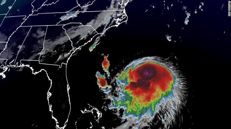
Tropical Storm Henri will be a hurricane on Saturday and make unusual landfall in New York, Rhode Island or Massachusetts on Sunday, according to the National Hurricane Center (NHC).
Henri has strengthened in the last hours and is almost a hurricane with winds of 112 km / h, according to the update of 2 p.m. Friday from the NHC.
"Risks of storm surge, wind and rain impacts in portions of southern New England and eastern Long Island are increasing," the center said Friday morning.
The last time a hurricane made landfall in this region was Hurricane Bob in 1991. But hurricanes have had significant impacts since then.
Irene and Sandy brought devastating conditions even though they did not make landfall as a hurricane.
The one that makes landfall as a hurricane means that the worst winds will hit the coast.
Follow Henri's career in real time
The forecast models for Friday morning are more consistent than two days ago.
However, there is still some mystery as to Henri's trajectory, intensity and effects until early next week.
advertising
"Given the uncertainties still present in Henri's future track and intensity and the hazards the storm may cause, storm surge and hurricane alerts are now being issued for parts of Long Island, Connecticut, Rhode Island and southeastern Massachusetts," it says the hurricane center.
Long Island and New England under 1:01 hurricane watch
Hurricane Watch means that hurricane conditions are possible within the watch area.
The watch is normally issued 48 hours before the first anticipated onset of tropical storm force winds.
Based on the new forecast, tropical-storm-force winds will approach the southern New England coast in about 48 hours, the NHC said.
Probability of tropical storm force winds through Wednesday.
"This is the first time in almost 10 years that we have a hurricane watch issued for parts of our area," tweeted the National Weather Service (NWS) in New York.
"The last time we had hurricane warnings issued for the area was for Hurricane Irene back in late August 2011."
The wind shear, that is, the change in wind speed and direction with height, has prevented Henri from strengthening in recent days.
That cutting is expected to end today, allowing Henri to reach hurricane status by Saturday.
Tropical storm Henri could become hurricane 2:22
Colder waters near shore often weaken a hurricane, but Henri is expected to move fast enough that these colder waters won't have much of an effect.
When the storm makes landfall, damaging winds and storm surges will be the greatest threats.
"Keep in mind that the tides will be astronomically high this weekend along both coasts," says the NWS in Boston.
Screening of bursts of watching until Sunday.
Sunday's full moon means higher high tides.
Any storm surge on top of already higher tides could trigger further coastal flooding.
"The trajectory will ultimately tell us which coast is most at risk (the east coast versus the south coast) or whether they will both be at risk," the NWS Boston said Thursday.
A 0.9 to 1.5 meter storm surge has been forecast from Cape Cod Bay to Narragansett Bay;
A storm surge of 0.6 to 1.2 meters is expected for the coast of Connecticut and New York, including Long Island, and a storm surge of 0.3 to 0.9 meters is forecast along the New Jersey coast to Cape May .
Grace strengthens as a Category 2 hurricane and is expected to make landfall in Mexico for the second time
A storm surge alert has also been issued for much of the region.
A storm surge warning means there is the potential for life-threatening flooding from rising water moving inland from the coast.
Heavy rains will also be a threat throughout the day on Sunday and into early next week.
Henri is forecast to produce showers of 50.8 to 127 millimeters in southern New England, with isolated highs near 203.2 millimeters.
"Generally, when storms hit New England, they are picked up by the jet stream and they move very quickly," says CNN meteorologist Brandon Miller.
"It will be very rare for a storm to move so slowly over the northeast."
That means storm surge, dangerous surf, coastal erosion and heavy rains will continue to hit New England for days instead of hours.
Henri will impact the United States, the forecasts coincide, but it is not yet known how much
The Massachusetts National Guard is activated in anticipation of Henri
In Massachusetts, Gov. Charlie Baker activated the state's National Guard on Friday, allowing up to 1,000 guards to assist in high water rescue, debris clearance and public safety related to Henri, he announced during a news conference.
Baker anticipates that there could be 100,000 to 300,000 power outages and said utility workers are being stationed at Camp Edwards ahead of the storm.
Baker urged people planning to travel to Cape Code or the islands this weekend to delay their trips, leave on Saturday, or plan to extend their stay until at least Monday or Tuesday because of Henri.
The governor urged Massachusetts residents to stay home Saturday night and stay there until Sunday, when Henri is expected to make landfall.
- CNN's Haley Brink, Monica Garrett and Amanda Watts contributed to this report.
HurricaneNew York