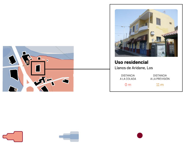
Click on a house for more information
Tongue
lava
Possible step
lava
Mouths
eruptive
Data updated on September 27 08.50 (Spanish peninsular time)
×
Charging
Note to readers: EL PAÍS offers the information in this infographic on the eruption of the volcano on La Palma as a public service.
If you want to support our journalism,
subscribe here
.
The unstoppable advance of lava through the Aridane Valley continues to engulf homes, roads and everything in its path, as satellite images show.
The outlook is bleak: about 260 hectares razed and 600 or 700 buildings destroyed, depending on the source and the counting method used (see methodology).
There are 2,000 meters to the sea and on its way there are hundreds of more houses.
The map prepared by EL PAÍS represents the extent of the lava each day, the predictions of its advance, the damaged houses and those at risk.
The perimeter of the lava in its advance is collected by the Copernicus program, the prediction is from the University of La Laguna, and the information on the constructions, from the Cadastre.
Below is the advance of the lava day by day:
Monday (day 1).
The first satellite shot collected the perimeter of the streams on Monday afternoon.
In 30 hours, the lava advanced more than three kilometers in the direction of the sea and covered 100 hectares of land
.
On his way he destroyed 232 buildings, most of them houses and annexes.
Tuesday (day 2).
The second image came 12 hours later.
The lava tongues had grown by 50% and already covered 155 hectares.
In their advance they
destroy 147 more buildings
, mostly residences, but also 20 for agricultural, industrial or commercial use.
Wednesday (day 3).
After 36 hours, the pouring slows down - the area covered by lava increases by just 10 hectares - but
engulfs another thirty buildings
.
Thursday (day 4).
The casting accelerates again and
in 12 hours the covered area has expanded 15 hectares
.
In that advance, gobble up 60 buildings.
Saturday (day 7).
At seven in the morning, 48 hours after the last update, the laundry has advanced 31 hectares.
Sunday (day 8).
The advance of the lava accelerated again and in 24 hours it advanced 21 hectares.
Monday (day 9).
.
From Sunday to Monday, the wash continued to advance and engulfed another set of houses as they crossed the highway in Todoque.
The lava surface spread 26 hectares and adds up to 257.
The total of buildings buried is 740
.
And now that?
The graph shows possible trajectories of the lava, according to a simulation by the University of La Laguna.
In the
area at risk
there are about 1,500 buildings.
The speed of progress has been uneven during the week.
The lava covered 150 hectares in the first 42 hours (three per hour), then advanced only 10 in the next 36 hours (0.3 per hour).
On Thursday the pace increased again, gaining 26 hectares in 25 hours (one per hour).
From Thursday to Saturday the advance was 20 hectares in 36 hours (0.5 per hour).
On Saturday the lava advanced about 20 hectares (one per hour).
From Sunday to Monday, the moment of the last image, the pace accelerated and the lava spread over another 20-30 hectares (one per hour).
On Sunday, September 26, SkySat captured the first satellite image showing lava flow.
It is a false-color image that allows you to better appreciate the dimensions of the eruption.Planet Labs Inc. / AP
The wash has already engulfed about 740 buildings, according to the latest satellite image on Thursday.
According to the cadastre, the majority are houses, garages and other residential constructions, although there are also 80 buildings for industrial, commercial or agricultural use.
Another 1,500 are intact, but at risk, most in the direction of the sea.
They are the buildings that are on the possible trajectories of the lava languages, according to the probabilistic predictions of the University of La Laguna.
A group of houses saved from the lava of the volcano.Emilio Morenatti / AP
Methodology.
The mapping of the area occupied by the lava is provided by the Copernicus satellite image program, at different times of the day.
The prediction of the possible advance of the pouring is a probabilistic estimate of the University of La Laguna.
We have taken the information on the constructions from the Cadastre, which provides the location, plan and photo of each building.
The calculation of the number of buildings under the lava is an approximation and may contain some errors, both by excess (for example, if a building is close to the wash, but safe), and by default (if there are constructions that do not appear in register).
Jacob Vicente López has collaborated in the preparation of this article.
You can follow MATERIA on
,
and
, or sign up here to receive
our weekly newsletter
.

