California: some of the catastrophic predictions 3:33
(CNN) —
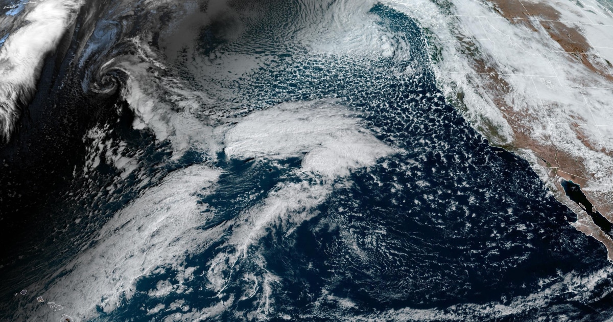
A Category 4 out of 5 atmospheric river is forecast to bring heavy rain, swollen rivers and snow to the Pacific Northwest early in the week.
On the river's atmospheric scale, a category 4 is characterized as "mostly dangerous" but also "beneficial" in terms of the amount of rainfall expected, according to the Center for Western Waters and Weather Extremes (CW3E). ).
Atmospheric rivers can be both good and bad.
On the good side, they are the largest contributor to the West Coast's water supply;
however, they are also the source of the most shocking floods in the region.
And this week is no exception in terms of heavy rain and flooding in Washington and Oregon.
"Beginning Sunday night, a strong atmospheric river will extend into western Washington and northwestern Oregon," the National Weather Service (NWS) office in Portland, Oregon said.
advertising
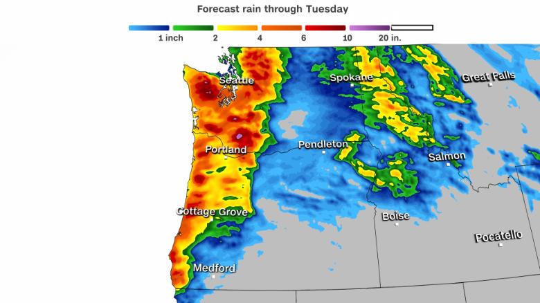
The heaviest rain is expected Monday through Tuesday morning, with 24-hour rainfall totals of 3 to 6 inches forecast along portions of the Washington and Oregon coasts.
There may be isolated amounts of more rain in parts of the Cascade Range during this same time frame.
This heavy rain event is coming off a relatively dry start to February.
As of Sunday morning, the Seattle-Tacoma airport had only received a little more than 1 inch of rain this month, which is a deficit of more than 25 inches for the month of February.
While the mountains will experience snow first, temperatures will slowly rise through higher elevations, leading to a change in rainfall.
As this transition occurs, the rain will cause additional snow melt, which could lead to flash flooding and rising rivers in the coming days.
"With so much rain and increasing snow levels, area rivers will rise and are forecast to flood," the NWS Seattle office said.
"The current forecast suggests that potentially most rivers in the area off the Cascades reach a minor flood stage Monday night through Tuesday, with moderate flooding in the Skokomish, Snoqualmie, Nisqually and Cowlitz".
As this system moves toward the coast, it will generate gusty winds in coastal communities and beaches, where gusts of 64 to 89 km/h are forecast.
Also along the coast, sleeper waves are possible on Sunday, meaning waves can travel much farther than normal on the beach, including over rocks and jetties.
"Sleeper waves can knock people over suddenly and quickly pull them into the ocean, which can lead to serious injury or drowning," the NWS Portland office said.
Due to high tides along the coast pushing inland and rising rivers bringing excess runoff, minor flooding along the coast is also possible on Monday and Tuesday. .
By Tuesday night, the Pacific Northwest could see a short break from heavy rain before another round of rain returns to the region on Wednesday.
Rainy Pacific