
Hail the size of golf balls falls in Arkansas after storm 0:50
(CNN) --
After four weeks of bad weather in the South, it was a sure sign that we were in full spring.
But mother nature had other plans... It looks like this week some of us will take a short break from spring to return to winter, as a rare northeastern storm called
a nor'easter
(so called because the winds in coastal areas come from typically Northeastern North America) late-season has its eyes set on the Northeast and New England.
"We have snow events in April even in Albany here. But they are not that frequent," said Tom Wasula, a meteorologist with the Albany National Weather Service (NWS).
"They can happen. I would say maybe once or twice a decade."
Nearly eight million people are under winter storm warnings and winter weather advisories in the interior parts of the Northeast.
Mid-April nor'easters aren't unheard of, but they are definitely rare, and they can cause significant problems.
A strong Nor'easter will bring significant, heavy snow to portions of the interior Northeast late tonight through Tuesday.
This heavy and wet snow will likely be hazardous and disruptive to travel and may lead to downed trees and power outages.
pic.twitter.com/qOwgACGz84
— NWS Weather Prediction Center (@NWSWPC) April 18, 2022
advertising
The region will be hit by everything from heavy, wet snow to high winds and coastal flooding, and there could be significant damage to trees and power lines, which could lead to widespread power outages.
The proximity of the nor'easters to the coast will largely determine who gets snow and who doesn't.
The farther from the coast they pass, the more likely big cities on the East Coast will get snow.
This week's nor'easter will head much further west, meaning precipitation in coastal cities will be rain only, and inland locations will get plenty of wet snow.
This does not mean that coastal cities are safe.
Rain, wind and coastal flooding will cause significant disruption throughout the Northeast and New England coastline.
This includes places like Philadelphia, New York, and Boston.
How will the storm develop?
The storm is currently producing heavy rain in the Carolinas and will continue to move up the East Coast and intensify.
The low will move away from the Mid-Atlantic coast tonight, which is when areas of the Northeast will begin to feel the effects of the storm.
"A band of heavy, wet snow, with rates of 25 to 50mm per hour, is expected to develop and move northward across the area between 11pm tonight and 8am Tuesday," he forecast. the NWS office in Burlington, Vermont.
"The subsequent rapid accumulation of snowfall will impact morning commutes and may lead to isolated or scattered power outages."
While most areas will see several inches of total snowfall, some places could see up to a foot of snow, especially at higher elevations.
"The real winners with the highest snowfall amounts of 6 to 12 inches will be the southern Adirondacks, eastern Catskills, and perhaps parts of Schoharie County," the Albany NWS office predicted.
As the storm moves northeast, coastal areas will also be affected.
Even places like Boston will get some "wicked" weather.
"The intense spring storm will bring some wet snow along the inland high ground, primarily above 1500 feet, and some nasty windswept cold rain elsewhere late Monday through Tuesday," he projected. the NWS office in Boston.
"The biggest concern, however, would be the potential for strong to damaging winds especially along and near the immediate coast of eastern and southeastern Massachusetts."
Windy conditions will be widespread.
"Expect winds along the coasts to increase to 20 to 30 mph with gusts to 45 to 50 mph," the NWS Philadelphia office said, referring to the Delaware and New Jersey coasts.
Wind advisories are in effect for much of the Northeast and New England coastline, as well as a portion of the northern Appalachians.
Winds could reach 88.5 km/h.
When combined with torrential rain, the forecast looks pretty dire.
The NWS office in New York City forecasts winds of 32 to 48 km/h with gusts up to 80.4 km/h.
Strong winds blowing off the coast will also cause coastal flooding.
A coastal storm impacts the region tonight, bringing heavy rain, strong winds, and coastal flooding.
Winds gradually increase through the day, and rain overspreads the region this evening, continuing into the overnight.
#NYwx #CTwx #NJwx
Full briefing: https://t.co/0R3hD7m3pr pic.twitter.com/KdZtDebQ4n
— NWS New York NY (@NWSNewYorkNY) April 18, 2022
"Flooding 12 to 24 inches above ground level is expected in vulnerable areas near the coast and coastline," the NWS New York City office said.
The same goes for the coastal areas of Delaware and New Jersey, especially during times of high tide.
And if the snow, rain, wind and coastal flooding don't seem like enough,
frigid temperatures can be expected after the
nor'easter passes.
"Temperatures will be cold enough that it looks like the calendar says 'February' and not 'April,'" the Weather Prediction Center (WPC) warned.
"The same can be said in the Midwest, where daytime temperature anomalies of 8 to 11°C below normal are expected on Tuesday."
Fire-prone weather remains critical
One area of the country that could use some rain is the desert southwest, but they won't because fire-prone conditions remain critical.
To date, more than 19,000 fires have burned more than 3,318 square kilometers across the United States, which is more than 809 square kilometers more than usually burn at this time, according to the National Interagency Fire Center.
There are 11 large active fires in five states.
Ten of them are burning in states with favorable conditions for fires.
"Dry westerly winds return Tuesday and hold for the rest of the week," the NWS office in Albuquerque reported.
"Wind advisories are likely to be needed Tuesday through Friday, with locally high and potentially damaging winds on Friday."
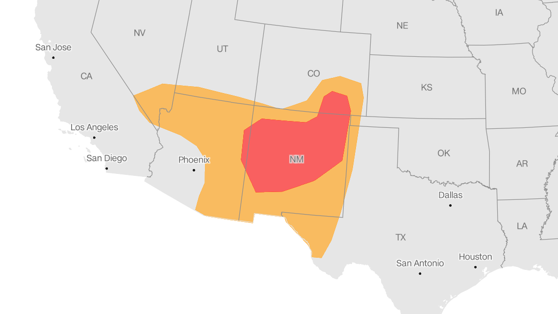
Much of New Mexico, as well as portions of Arizona and Colorado, will remain under critical fire danger, with winds of up to 80 km/h across many areas.
Fire risk forecast for April 19, 2022.
Orange areas are at high risk, while red areas are at even higher risk.
Updated on Monday, April 18, 2022 at 3:02 am ET.
Source: NWS Storm Prediction Center.
Graphic: John Keefe.
"Dry, windy conditions will be more prevalent across the central and southern High Plains, where fuels are critically dry and highly conducive to the rapid spread of wildfires," the Storm Prediction Center (SPC) warned. its acronym in English).
Areas of southern New Mexico will experience near-record heat with temperatures reaching 90°F.
The combination of warm temperatures and strong winds will fan the flames of any new or existing fire.
While dangerous fire-prone conditions appear likely to remain for at least the next seven days, "the strongest winds appear to occur Tuesday and especially Friday," the NWS Albuquerque office noted.
snow storm usa


/cloudfront-eu-central-1.images.arcpublishing.com/prisa/FNKLLK5XKNWEKUJYBF4ZFC5S6U.jpg)
