
This is how the Tunnel wildfire in Arizona feeds 1:11
(CNN Spanish) --
A system of strong storms moving through the Rocky Mountains and the Plains on Friday will generate winds that increase concerns of more fires in the Southwest and tornadoes in the Great Plains of the United States.
With the West mired in one of the worst droughts in decades, fire season has not only started early, but has already broken records.
Since January, more than 404,000 hectares have been burned, well above the average for the year to date, which is around 256,000.
New Mexico, where five major fires are currently burning, has been particularly hard hit, and the forecast for the next few days offers no chance of respite.
New Mexico has already reached its annual rate of fire activity and we are only in April.
"Our season started earlier than it has in the past," said Andrew Church, a meteorologist with the National Weather Service's (NWS) Albuquerque office.
advertising
"Because of climate change and the mega-drought throughout the western United States, there is simply no moisture in the soil anymore," he explained.
This lack of soil moisture, high temperatures and strong winds are the main factors that will cause existing and new fires to spread out of control.
Threat of critical fires increases to the most extreme level
Red flag warnings have been issued as the winds will whip through some of the driest air yet, especially in Kansas, Colorado and New Mexico.
Friday's fire danger will be raised to "extremely critical" level 3, the highest possible, as conditions worsen.
The area facing Level 3 conditions encompasses portions of southeastern Colorado, including the city of Pueblo.
"Winds in this area are expected to be sustained at 30 to 40 mph, with gusts to 55 mph," the Storm Prediction Center said.
"We've already had three days at the extreme level this year and we were a little worried about this one. We've had multiple fires so far this year," said Kyle Mozley, an NWS meteorologist in Pueblo.
"Any fire that starts will have the ability to spread rapidly and that includes throwing cigarette butts into fire pits onto downed power lines and things like that, that would be another fear," Mozley added.
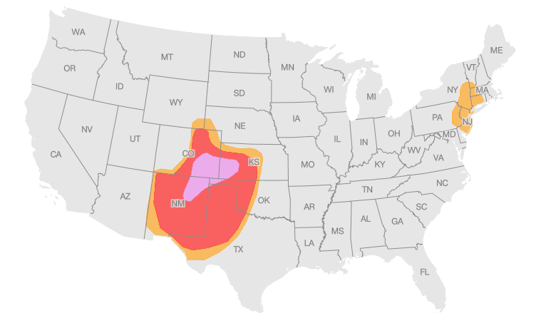
Fire risk outlook from Friday, April 29 at 1:00 pm Miami time to Saturday, April 30 at 8:00 am Miami time.
The orange color identifies areas with high risk and purple those with extreme risk.
Source: National Weather Service Storm Prediction Center
Graphic: John Keefe, CNN
"Along with this 'extreme' concern, we cannot rule out the expanded 'hotspot' zone, which covers parts of five states (New Mexico, Colorado, Texas, Oklahoma and Kansas) and includes Albuquerque, Colorado Springs, Lubbock, Amarillo and Midland, Texas," the Storm Prediction Center said.
"Dry and windy conditions in the region will be at the top of the critical threshold, close to the extreme critical criteria."
The major fires they are currently monitoring include the Tunnel Fire in Arizona, where some 7,700 acres have burned and are 89% contained, and the Hermits Peak/Calf Canyon Fire in New Mexico, which has spread to some 25,800 acres and is at 33% containment.
It's hard to believe, but the drought is going to get worse
The US Drought Monitor brought more bad news on Thursday.
The Southwest and South Plains have seen a further intensification of drought in the past week.
"Deterioration was common across the Southwest, with exceptional drought (the second-highest designation) spreading widely in New Mexico and moderate-to-severe drought increasing coverage in parts of Arizona and Colorado," states the report. drought summary.
New Mexico has doubled the area covered by exceptional drought (the highest level);
it now comprises more than 15% of the state.
Drought in the state has steadily intensified since the beginning of the year, with nearly 68% of the state now in extreme to exceptional drought.
"It looks like it's going to get worse before it gets better," Church said.
"We used to see relative humidity go up behind cold fronts, but with the ground moisture completely depleted, the air stays dry at single-digit relative humidity and gives rise to these fire threats," he explained.
He continued: "We may have to wait quite a while for the monsoon rains to make an appearance, hopefully sometime in late June."
Rain for the east, but with another threat
On Friday there is a different threat on the plains.
Needed rains miss the West and Southwest, but thunderstorms could turn violent across the Plains, with strong weather elements like damaging winds, large hail and even tornadoes, as a powerful storm moves westward from the Rockies. East.
The Storm Prediction Center has raised the threat of severe storms to a 4 out of 5 risk level for portions of Kansas and Nebraska, including Lincoln and Hastings.
"All severe weather hazards will be possible, but destructive wind gusts may ultimately become the most widespread hazard across south-central to eastern Nebraska and north-central/northeast Kansas," said the center on your updated information.
Severe Weather Risk Outlook from Friday, April 29 at 12:30 pm Miami time through Saturday, April 30 at 8:00 am Miami time.
The green color marks low risk and from there in the following order: yellow, orange, red and purple (which marks high risk).
Source: National Weather Service Storm Prediction Center
Graphic: John Keefe, CNN
In total terms, the major storm threat encompasses more than 10 million people in the Central Plains, where "multiple forecast scenarios are expected to develop this afternoon and continue into the evening," according to the center.
Destructive winds are possible in parts of Nebraska and Kansas, as well as some strong tornadoes and very large hail (baseball to softball sized) Friday afternoon and into the evening hours.
Strong storms are expected to be more active in the afternoon and evening.
Meteorologist Ray Sondag of the NWS in Tulsa told CNN he expects the worst time to be between 6 pm and midnight.
"If there is a dry line configuration, which we think there will be, these thunderstorms will move into southeastern Oklahoma and could produce tennis ball-sized hail along with 70 mph winds and a few tornadoes."
On Saturday, the Midwestern cities of St. Louis, Chicago and Indianapolis will be under threat of severe storms.