
Remnants of Agatha head for Florida 0:53
(CNN) --
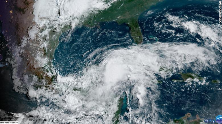
A tropical storm watch has been issued for the east and west coasts of Florida, including Miami, Sarasota, Key West, West Palm Beach and Melbourne, while a potential tropical cyclone near the Yucatan Peninsula has been designated, according to the National Hurricane Center.
Florida braces for impact from Agatha's remnants
A potential cyclone is a term used to describe a weather mismatch that is not yet a depression or tropical storm, but is forecast to become one and threaten the mainland within 48 hours.
Maximum sustained winds are currently 56 km/h and the system is expected to strengthen to a Tropical Depression this Friday and possibly to Tropical Storm Alex in the afternoon or evening.
Based on the current forecast track, the system should move across south and central Florida this Saturday.
Heavy rain and flooding will be the main threat from the storm, with rainfall totals ranging from 4 to 8 inches, with 12 inches of rain in the southern half of the state and the Keys.
Flood watches are already in effect for much of South Florida, including Miami.
Satellite images of the cluster of showers and thunderstorms that could form into a tropical depression or tropical storm this Thursday or Friday.
When a tropical storm watch or warning is issued, that means there is a chance that people within those watches or warnings will experience tropical storm weather conditions for the next several days.
advertising
For the storm to be named Alex, the first name of the 2022 hurricane season, the system will have to strengthen and reach sustained winds of 62 km/h or higher.
This storm system may very well remain a tropical depression and may never gain the wind strength to earn a name.
"Whether the storm organizes or not, significant flooding is possible in South Florida and the Keys," says CNN meteorologist Chad Myers.
"It's too early to say where the heaviest rains will be because it's not a storm yet, but models indicate 12-16 inches of rain is possible in the hardest-hit areas."
The red zone shows the probable site of the tropical formation.
"There is still some variability in how this system will play out, but heavy rainfall capable of dispersing numerous flash floods across South Florida and into the Keys is certainly plausible," the Weather Prediction Center (WPC) said. for its acronym in English) this Thursday morning.
They forecast a moderate risk, level 3 of 4, of excessive precipitation, which could lead to flash flooding.
Deep tropical moisture will surge ahead of the likely storm and over southern Florida throughout Friday and into Saturday.
South Florida is most likely on the path
Computer forecasting models are beginning to agree that a tropical storm or depression will form and affect South Florida.
"The latest guidance models are beginning to agree that this low will pass somewhere over the southern part of the Florida panhandle during the day on Saturday," the National Weather Service in Miami said Thursday morning.
The track is important because taking a more southerly route could keep the densely populated areas of South Florida out of the severe threat coming from the northeast side of tropical storms and hurricanes.
"High winds and one or two isolated tornadoes will be the main severe threat on Friday and into Saturday," the NWS in Miami said.
"These details remain uncertain as it will depend on the exact course the system takes. A more southerly track would put the northeast quadrant above the waters, which would be a better case scenario regarding severe weather across South Florida." .
A tropical depression is "likely" to form from Agatha's remnants before it hits Florida
So track matters, even if it's just a tropical storm.
Chad Myers warns that until the NHC pinpoints the exact center of this storm, forecast models will struggle to accurately predict the path of this storm.
"A hurricane hunter aircraft is heading to the area today and it is hoped that it will be able to find the true center of any circulation," says Myers.
That information will be used in computer model runs Thursday night, giving a better indication of the storm's track and potential strength.
On Wednesday night, without knowing the exact location of the center of the storm system, the US model had 3 different low-pressure locations at exactly the same time, Myers explains.
"To me, this indicates that the wind shear in the area may slow down the organization of the potential storm and, for now, prevent it from growing rapidly."
This system has two of the three ingredients needed to form a hurricane
For a hurricane to form, you need "warm ocean water, low wind shear and a pre-existing group of storms... we've got 2 of the 3 right now," says Myers.
Wind shear is the change in speed and direction of the wind as it rises in the sky.
If it is strong, as it is now in the Gulf of Mexico, it makes it difficult for hurricanes to form.
"We have a lot of opposing forces here," says Myers.
"It's like trying to speed up the car and not realizing the emergency brake is on."
If the brake, the wind shear, decreases, there is a small chance that this storm will intensify more than anticipated.
However, this is the least likely scenario.
Another Above-Average Hurricane Season Forecast
Last week, the National Oceanic and Atmospheric Administration (NOAA) published its forecast for this hurricane season.
The administration anticipates an above-average year, with 14-21 named storms, 6-10 hurricanes, and 3-6 major hurricanes, Category 3 or higher.
There are several factors that contribute to a "heavy" hurricane season.
"We're in an active period," NOAA Administrator Rick Spinrad said.
"There are certain ingredients that drive the intensity and frequency of hurricanes."
Hurricane forecast for 2022: how many are expected in Mexico and the US?
One of them is the conditions of the meteorological phenomenon known as La Niña existing in the equatorial Pacific.
This phenomenon creates cooler than average ocean temperatures around the equator in the Pacific and causes weather impacts around the world.
La Niña presents favorable conditions for hurricanes in the Atlantic, in contrast to those of El Niño.
This morning, the Colorado State University (CSU) updated its forecasts.
It now forecasts a much better hurricane season, with 20 named storms, 10 hurricanes and 5 major hurricanes.
This is the highest number of named storms the CSU has forecast for the season in June, Phil Klotzbach, the forecast's author, told CNN.
In 2020, the university's forecast center predicted 19 storms during its June release, but that number included three storms that were named before the season began.
This year, no storm has yet formed.
Tropical storm