
By EFE
Tropical storm Karl, on its way to the southern coast of Mexico, where it will make landfall this Saturday, can cause flash floods and landslides in sectors of the south of the country.
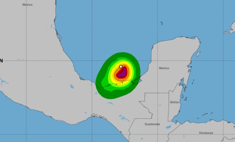
The National Hurricane Center of the United States (NHC, for its acronym in English) reported this Friday in its bulletin at 21:00 GMT (5:00 pm, Eastern Time) that, at that time, the center of the system was It was located about 95 miles from Ciudad del Carmen, southwest of the Yucatan peninsula, and 135 miles from Coatzacoalcos, a city in the state of Veracruz.
Karl is moving forward with maximum sustained winds of
40 miles per hour.
Tropical Storm Karl is moving south and southwest near 5 miles per hour. Via National Hurricane Center (NHC).
A tropical storm warning is in effect from Coatzacoalcos to Sabancuy, in the southwestern Mexican state of Campeche.
Tropical Storm Karl is moving south and southwest near 5 miles per hour and is expected to turn south over the Bay of Campeche.
On the forecast track, the center of Karl should be near the coast of southern Mexico this Saturday.
[Southeastern Mexico is under alert after formation of storm Karl in the Bay of Campeche]
Gradual weakening is forecast
and Karl is expected to become a tropical depression by early Saturday and dissipate by Sunday.
Tropical storm force winds extend up to 70 miles from the center.
[Under a tropical storm watch for northeastern Mexico and southern Texas]
The forecast is that tropical storm conditions will be registered in sectors under warning on Friday night.
The swells generated by Karl
will affect the Mexican coast
during the next few days and will cause conditions of surf and strong marine currents.